Related Research Articles
The Gascoyne region is one of the nine administrative regions of Western Australia. It is located in the northwest of Western Australia, and consists of the local government areas of Carnarvon, Exmouth, Shark Bay and Upper Gascoyne. The Gascoyne has about 600 km (370 mi) of Indian Ocean coastline; extends inland about 500 km (310 mi); and has an area of 135,073.8 km2 (52,152.3 sq mi), including islands.

North West Coastal Highway is a generally north-south Western Australian highway which links the coastal city of Geraldton with the town of Port Hedland. The 1,300-kilometre-long (808 mi) road, constructed as a sealed two-lane single carriageway, travels through remote and largely arid landscapes. Carnarvon is the only large settlement on the highway, and is an oasis within the harsh surrounding environment. The entire highway is allocated National Route 1, part of Australia's Highway 1, and parts of the highway are included in tourist routes Batavia Coast Tourist Way and Cossack Tourist Way. Economically, North West Coastal Highway is an important link to the Mid West, Gascoyne and Pilbara regions, supporting the agricultural, pastoral, fishing, and tourism industries, as well as mining and offshore oil and gas production.

The Murchison River is the second longest river in Western Australia. It flows for about 820 km (510 mi) from the southern edge of the Robinson Ranges to the Indian Ocean at Kalbarri. The Murchison-Yalgar-Hope river system is the longest river system in Western Australia. It has a mean annual flow of 208 gigalitres, although in 2006, the peak year on record since 1967, flow was 1,806 gigalitres.

The Shire of Upper Gascoyne is a local government area in the Gascoyne region of Western Australia, inland from Carnarvon and about 1,000 kilometres (620 mi) north of the state capital, Perth. The Shire has an area of 57,939 square kilometres (22,370 sq mi), much of which is uninhabited land or sparsely vegetated sheep station country, and its seat of government is the small town of Gascoyne Junction. It has a population of 170, 56% of whom identify as Aboriginal.

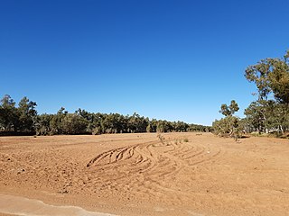
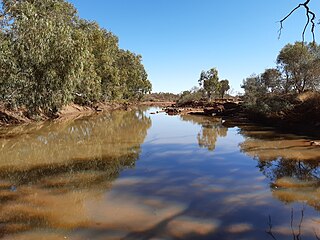
The Gascoyne River is a river in the Gascoyne region of Western Australia. At 865 kilometres (537 mi), it is the longest river in Western Australia.

Gascoyne Junction is a small town in the Gascoyne region of Western Australia, inland from Carnarvon on the junction of the Gascoyne River and Lyons River. At the 2006 census, Gascoyne Junction had a population of 149.
Western Australia has the longest coastline of any state or territory in Australia, at 10,194 km or 12,889 km. It is a significant portion of the coastline of Australia, which is 35,877 km.
The Carnarvon Basin is a geological basin located in the north west of Western Australia which extends from the Dampier Archipelago to the Murchison bioregion, and is the main geological feature that makes up the North West Shelf. The onshore part of the Carnarvon Basin covers about 115,000 km2 and the offshore part covers approximately 535,000 km2 with water depths up to 3,500 metres. It is separated into two major areas - the Northern Carnarvon Basin, and the Southern Carnarvon Basin.
The Robinson Ranges are a range of hills approximately 120 kilometres (75 mi) north of Meekatharra in central Western Australia. The range is a unique physiographic feature located within the upper section of the Padbury group sequence in the Palaeoproterozoic basin. Robinson Range is situated on the boundary between the younger Gascoyne province to the north and the older Yilgarn block to the south.
The Lyons River is a river in the Gascoyne region of Western Australia.
The Landor River is a river in the Gascoyne region of Western Australia.
The Thomas River is a river in the Gascoyne region of Western Australia.

The 2010 Gascoyne River flood was regarded as the most severe flood to take place along the Gascoyne River in Western Australia on record. Triggered by record-breaking rainfall, amounting to over 6,000 percent of the monthly mean, 313.6 mm (12.35 in) and 5 mm (0.20 in) respectively, in just four days, the floods caused widespread damage in the region. By 17 December, the river began to rise in response to the heavy rains, eventually exceeding its banks within two days. Water levels reached record values at three stations along the river, cresting at 15.53 m (51.0 ft) near Fishy Pool. Evacuation orders were issued for several towns affected by rising waters. The most substantial impact was felt in Carnarvon where entire homes were washed away. Following the disaster, emergency supplies and funds were distributed to affected residents to aid them in restoring their livelihoods. Though no people died in the event, an estimated two thousand head of cattle perished and damage was estimated at A$100 million.
Three Rivers or Three Rivers Station is a pastoral lease and sheep station located in the Mid West region of Western Australia. Three Rivers and the neighbouring Bryah Station occupy an area of 513,000 hectares on the headwater of the Gascoyne River and primarily composed of grasslands.
Landor or Landor Station is a pastoral lease and sheep station located in the Gascoyne region of Western Australia.
Jimba Jimba Station, most often referred to as Jimba Jimba, is a pastoral lease currently operating as a cattle station in Western Australia, that once operated as a sheep station.
Brickhouse Station, formerly spelt Brick House Station, is a pastoral lease in Western Australia. It once operated as a sheep station but now operates as a cattle station, with some 90 ha turned over to mango cultivation.
Doorawarrah Station, commonly referred to as Doorawarrah, is a pastoral lease that operates as a cattle station in Western Australia.

References
- ↑ Gazetteer of Australia (1996). Belconnen, ACT: Australian Surveying and Land Information Group.
- ↑ "Place names of Australia". Geoscience Australia. 2004.
24°41′42″S115°19′14″E / 24.69500°S 115.32056°E
| | This Australian geography article is a stub. You can help Wikipedia by expanding it. |