Related Research Articles
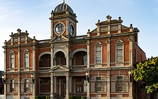
Castlemaine is a town in west central Victoria, Australia, in the Goldfields region about 120 kilometres northwest by road from Melbourne and about 40 kilometres from the major provincial centre of Bendigo. It is the administrative and economic centre of the Shire of Mount Alexander. The population at the 2021 Census was 7,506. Castlemaine was named by the chief goldfield commissioner, Captain W. Wright, in honour of his Irish uncle, Viscount Castlemaine.

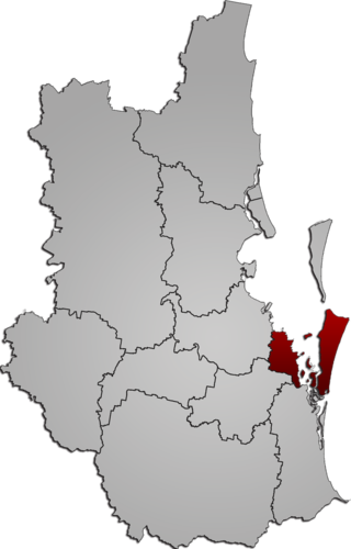
The Mount Alexander Shire is a local government area in Victoria, Australia, located in the central part of the state. It covers an area of 1,530 square kilometres (590 sq mi) and, in August 2021, had a population of 20,253. It includes the towns of Castlemaine, Chewton, Elphinstone, Maldon, Newstead, Harcourt, Taradale, Vaughan, Fryerstown and Campbells Creek. It was formed in 1995 from the amalgamation of the City of Castlemaine, Shire of Newstead, and most of the Shire of Maldon and Shire of Metcalfe. The traditional owners of the land are Dja Dja Wurrung.

Stawell ( "stall"), is an Australian town in the Wimmera region of Victoria 237 kilometres (147 mi) west-north-west of the state capital, Melbourne. Located within the Shire of Northern Grampians local government area, it is a seat of local government for the shire and its main administrative centre. At the 2021 census, Stawell had a population of 6,220.
Local government is the third level of government in Australia, administered with limited autonomy under the states and territories, and in turn beneath the federal government. Local government is not mentioned in the Constitution of Australia, and two referendums in 1974 and 1988 to alter the Constitution relating to local government were unsuccessful. Every state/territory government recognises local government in its own respective constitution. Unlike the two-tier local government system in Canada or the United States, there is only one tier of local government in each Australian state/territory, with no distinction between counties and cities.
Redland City, also known as the Redlands and formerly known as Redland Shire, is a local government area (LGA) and a part of Greater Brisbane in South East Queensland, Australia. With a population of 159,222 as of June 2021, Redland City is spread along the southern coast of Moreton Bay, covering 537.2 square kilometres (207.4 sq mi). The city borders the City of Brisbane to the west and north-west and Logan City to the south-west and south, while its islands are situated north of the City of Gold Coast.
Lillydale Lake is an artificial lake and wetlands area created in Lilydale, an outer eastern suburb of Melbourne, Victoria, Australia. The park in which the lake is situated covers over 100 hectares and includes extensive recreational facilities.

Alexandra is a town in north-east Victoria, Australia, 130 kilometres north-east of the State Capital, Melbourne. It is located at the junction of the Goulburn Valley Highway (B340) and Maroondah Highway (B360), in the Shire of Murrindindi local government area. At the 2021 census, the town had a population of 2,801 and the broader area a population of 6,828.

Newstead is a town in Victoria, Australia, situated along the Loddon River. It is in the Shire of Mount Alexander local government area. At the 2016 census, Newstead had a population of 572. Newstead has many festivals and folk events and is in the centre of the golden triangle, close to many tourist attractions and events.
Amphitheatre is a town in Victoria, Australia. It is located on the Pyrenees Highway in the Pyrenees Shire, south-west of Avoca. At the 2021 census, Amphitheatre and the surrounding area had a population of 223.
Pioneer Oval is located in the town of Parkes, New South Wales, Australia. It was carved out of a hill in eastern Parkes during the depression years and has evolved into one of country New South Wales' premier sporting arenas, playing host to major local, regional, national and international sporting events.
Yarra Plenty Regional Library (YPRL) provides a public library service to the local government municipalities of the City of Banyule, Shire of Nillumbik and City of Whittlesea in the northeast of Melbourne Australia and located on the lands of the Woiworung. It is an independent legal entity with an executive management team which is responsible for day-to-day operations of the organisation. It is managed by the Yarra Plenty Regional Library Board made of two representatives (councillors) of the three municipalities that constitute the service. Its role is to set the policy and direction for the regional library service. The library service covers an area of 988.4 km² including metropolitan, urban fringe and rural populations. The organisation is administered from its Library Support Services (LSS) located at Daniher Drive, Sth Morang.

The Shire of Newstead was a local government area about 120 kilometres (75 mi) northwest of Melbourne, the state capital of Victoria, Australia. The shire covered an area of 409.22 square kilometres (158.0 sq mi), and existed from 1860 until 1995.

Campbells Creek is a town in Victoria, Australia.

Kangaroo Ground War Memorial Park is located at 385 Eltham Yarra Glen Road, Kangaroo Ground in the Shire of Nillumbik. in Victoria, Australia. The site includes the war memorial, with a firespotting cabin, mature monterey cypress trees and other planted species, and a sandstone caretaker's cottage. The park is situated on the summit of Garden Hill, from which panoramic views are obtainable. The park is situated on two acres.
RPP FM is a community radio station in the Mornington Peninsula region of Victoria, Australia. The radio station was established in 1984 to provide a local community radio service to the region.
Eureka Stadium, known commercially as Mars Stadium, is an oval-shaped sports stadium located in the Eureka Sports Precinct of Wendouree, 2.9 km (1.8 mi) north of the CBD of the city of Ballarat, Victoria, Australia.
Set at the back of Campbells Creek, the trees here were originally selected by Baron Von Mueller, the famed botanist who designed the Castlemaine Botanical Gardens. The 37-40 Campbells Creek Fryer Road Reserve is the sport and recreation hub for the local community, and features:
Previously known as Pakenham East, Honora Fields is the newest suburb of the Greater Melbourne metropolitan area situated south-east of Melbourne City. Honora Fields is located in the Shire of Cardinia local government area.
Strangways is a locality split between the local government areas of Hepburn Shire and Mount Alexander Shire, in Central Victoria, Australia. It covers an area of 20.105 square kilometres between the townships of Guidford to the east, Newstead to the north-west and Clydesdale to the south.
Ocean Reef Marina is a development project in Ocean Reef, Western Australia to construct a new marina with commercial and residential areas at the existing Ocean Reef Boat Harbour. The site is being developed by DevelopmentWA; construction of its two breakwaters started in April 2021, with the whole project expected to be fully completed in 2036 and then becoming part of the City of Joondalup. The concept for a marina by developers in the area of Mullaloo and Ocean Reef had been proposed as far back as 1973.
References
- ↑ "Campbells Creek Community Plan" (PDF). 2014 Campbells Creek Community Plan. Mt Alexander Shire Council. 2014. Retrieved 19 November 2015.