
Salta is a province of Argentina, located in the northwest of the country. Neighboring provinces are from the east clockwise Formosa, Chaco, Santiago del Estero, Tucumán and Catamarca. It also surrounds Jujuy. To the north it borders Bolivia and Paraguay and to the west lies Chile.

The Bermejo River is a river in South America that flows from Bolivia to the Paraguay River in Argentina. The river is generally called Bermejo in spite of its different names along its way, but it also has its own Native American names; in Wichí it is called Teuco, and in Guaraní it is called Ypitá. In the plains of Argentina's Gran Chaco the Bermejo forms wetlands and splits into two branches. The southern branch is the bed of the old Bermejo River, now an intermittent stream called Río Bermejito. The northern branch is now the main stem of the Bermejo and is called the Teuco River, Bermejo Nuevo, or simply the Bermejo River. The two branches rejoin at 25°39′S60°11′W, near Villa Río Bermejito, forming the Lower Bermejo River.

The Tren a las Nubes is a tourist train service in Salta Province, Argentina. The service runs along the eastern part of the Salta–Antofagasta railway line of the Belgrano Railway that connects the Argentine Northwest with the border in the Andes mountain range, over 4,220 metres (13,850 ft) above mean sea level, the fifth highest railway in the world. Originally built for economic and social reasons, it is now primarily of interest to tourists as a heritage railway, though cheaper tickets are also available for locals to use the train as transport.

The Puna de Atacama or Atacama Plateau is an arid high plateau, in the Andes of northern Chile (15%) and northwest of Argentina (85%). Geomorphologist Walther Penck based his Grossfalt landform association on Puna de Atacama.
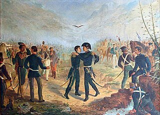
The Posta de Yatasto is an estate located near San José de Metán, Salta Province, Argentina. It is known for the historical meetings that took place at the site during the Argentine War of Independence, and was designated a National Monument of Argentina in 1942.

Aguas Blancas (Salta) is a village and rural municipality in Salta Province in northwestern Argentina. It is a city in the Oran department, located northeast of the province of Salta, Argentina. Aguas Blancas is located on the right bank of the Bermejo River, which forms a natural boundary between Argentina and Bolivia. The city Bermejo, Bolivia is on the opposite bank of the river.
Acoyte (Salta) is a village and rural municipality in Salta Province in northwestern Argentina.
Copo Quile is a village and rural municipality in Salta Province in northwestern Argentina.

Los Toldos (Salta) is a village and rural municipality in Salta Province in northwestern Argentina.
Macapillo is a village and rural municipality in Salta Province in northwestern Argentina.
Misión Tierras Fiscales is a village and rural municipality in Salta Province in northwestern Argentina.
San José de Orquera is a village and rural municipality in Salta Province in northwestern Argentina.
Colonia Santa Rosa is a town and municipality in Salta Province in northwestern Argentina.

El Galpón (Salta) is a town and municipality in Salta Province in northwestern Argentina.
Embarcación (Salta) is a town and municipality in Salta Province in northwestern Argentina.
Joaquín Victor González is a town and municipality in Salta Province in northwestern Argentina. It is located in and is the capital of Anta Department. It was founded as Laguna Blanca but changed to be named after Joaquin V. Gonzalez after a railroad was built in the area. Its industries are manufacturing of wood-based goods. Its population is 21,045 with 10,567 men and 10,478 women.
Bryde Island is an island 6 nautical miles long and 3 nautical miles wide, lying immediately southwest of Lemaire Island, off the west coast of Graham Land, Antarctica.

Albertogaudrya is an extinct genus of astrapotherian mammal that lived in present-day Patagonia and Salta, Argentina during the Eocene 48.6 to 37.2 million years ago. Fossils of Albertogaudrya have been found in the Lumbrera and Sarmiento Formations. It is named after French palaeontologist Albert Gaudry.
Salta Basin or Salta Rift Basin is a sedimentary basin located in the Argentine Northwest. The basin started to accumulate sediments in the Early Cretaceous (Neocomian) and at present it has sedimentary deposits reaching thicknesses of 5,000 metres (16,000 ft). The basin contains seven sub-basins: Tres Cruces, Lomas de Olmedo, Metán, Alemanía, Salfity, El Rey, Sey and Brealito. The basin environment has variously been described as a "foreland rift" and an "intra-continental rift". The basin developed under conditions of extensional tectonics and rift-associated volcanism.
