
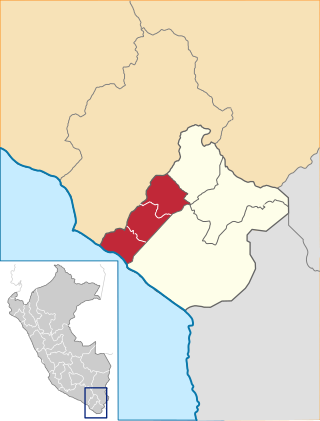
Candarave Province is the smallest of four provinces in the Tacna Region in southern Peru. Its capital is Candarave.
Jorge Basadre Province is one of four provinces in the Tacna Region in southern Peru. Its capital is Locumba. The province was created on April 21, 1988 and is named after Jorge Basadre Grohmann, the country's most notable historian.

Tarata is one of four provinces in the Tacna Region in southern Peru. Its capital is Tarata city.
Candarave District is one of six districts of the province Candarave in Peru.
Cairani is one of six districts of the Candarave Province in Peru.
Camilaca District is one of six districts of the province Candarave in Peru.
Curibaya District is one of six districts of the province Candarave in Peru.
Huanuara District is one of six districts of the Candarave Province in the Tacna Region in Peru.
Quilahuani District is one of six districts of the province Candarave in Peru.
Pachía District is one of ten districts of the province Tacna in Peru.
Arapa District is one of fifteen districts of the province Azángaro in Peru.
Asillo District is one of fifteen districts of the province Azángaro in Peru.
Lampa District is one of ten districts of the province Lampa in Peru.

Veselie Glacier is the 7 km long and 2.5 km wide glacier in Austa Ridge on Oscar II Coast in Graham Land situated southeast of Jorum Glacier and northeast of Chernoochene Glacier. It flows east-southeastwards along the north slopes of Mount Birks to enter Spillane Fjord west-southwest of Caution Point. The feature is named after the settlement of Veselie in Southeastern Bulgaria.
Lake Paracota or Laguna Parinacota is a lake in Peru located in the Tacna Region, Candarave Province, Candarave District. It is situated at a height of about 4,512 metres (14,803 ft). Lake Paracota lies between the larger Lake Suches in the northwest and the volcano Tutupaca in the south.
Challuma is a 5,187-metre-high (17,018 ft) mountain in the Andes of southern Peru near a lake of the same name. It is situated in the Moquegua Region, Mariscal Nieto Province, Carumas District, and in the Tacna Region, Candarave Province, Candarave District. It lies northeast of the mountain Churilaca.
Churilaca is a 5,260-metre-high (17,257 ft) mountain in the Andes of southern Peru. It is situated in the Moquegua Region, Mariscal Nieto Province, Carumas District, and in the Tacna Region, Candarave Province, Candarave District. Churilaca lies south-west of the mountain Challuma.
Wila Wilani or Ch'ankha Qullu is a mountain in the Andes of southern Peru, about 4,900 metres (16,076 ft) high. It is located in the Moquegua Region, Mariscal Nieto Province, Carumas District, and in the Tacna Region, Candarave Province, Candarave District. It lies west of a lake named Aqhuya Ch'alla, northwest of Paxsi Awki and east of Churi Laq'a, Ch'alluma and Ch'ankhani.
Pacocollo also known as Chancane, is a 5,113-metre-high (16,775 ft) mountain in the Andes of southern Peru. It is located in the Moquegua Region, Mariscal Nieto Province, Carumas District, and in the Tacna Region, Candarave Province, Candarave District. Pacocollo lies west of a lake named Pasto Grande or Ajuachaya and Wila Wilani.
Sasawini is a mountain in the Andes of southern Peru, about 5,000 m (16,000 ft) high. It is located in the Tacna Region, Candarave Province, Candarave District. It lies southeast of a lake named Such'i (Suches). Jichu Qullu is south of it.
