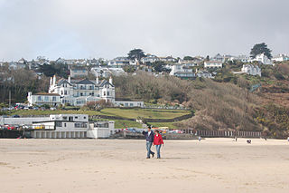
Carbis Bay is a seaside resort and village in Cornwall, England. It lies 1 mile (1.6 km) southeast of St Ives, on the western coast of St Ives Bay, on the Atlantic coast. The South West Coast Path passes above the beach.

St Erth is a civil parish and village in Cornwall, England.

The St Ives Bay Line is a 4.25 miles (6.84 km) railway line from St Erth to St Ives in Cornwall, England, United Kingdom. It was opened in 1877, the last new 7 ft broad gauge passenger railway to be constructed in the country. Converted to standard gauge in 1892, it continues to operate as a community railway, carrying tourists as well as local passengers. It has five stations including the junction with the Cornish Main Line at St Erth.

St Keyne is a village in the civil parish of St Keyne and Trewidland, in east Cornwall, England, United Kingdom. The parish lies between the parishes of Liskeard and Duloe. The parish population at the 2011 census was 492.

Gwinear–Gwithian is a coastal civil parish in west Cornwall, England, United Kingdom. It includes the villages of Connor Downs, Gwinear, Gwithian, Reawla and Rosewarne. The parish is situated approximately two miles (3 km) east of Hayle two miles (3 km) west of Camborne.

Ludgvan is a civil parish and village in Cornwall, England, UK, 2+1⁄2 miles (4.0 km) northeast of Penzance. Ludgvan village is split between Churchtown, on the hill, and Lower Quarter to the east, adjoining Crowlas. For the purposes of local government, Ludgvan elects a parish council every four years; the town elects a member to Cornwall Council under the Ludgvan division.
St Clether is a civil parish and village in Cornwall, England, United Kingdom. The village is situated on the east flank of Bodmin Moor approximately eight miles (13 km) west of Launceston in the valley of the River Inny. The population of the civil parish at the 2011 census was 156.

Grade–Ruan is a civil parish on the Lizard peninsula in Cornwall, England, United Kingdom, approximately ten miles (16 km) south of Falmouth.

St Anthony-in-Meneage is a coastal civil parish and village in Cornwall, England, United Kingdom. The parish is in the Meneage district of the Lizard peninsula. In the 2001 census the parish had a population of 171, decreasing to 168 at the 2011 census.
The River Hayle is a small river in West Cornwall, England, United Kingdom which issues into St Ives Bay at Hayle on Cornwall's Atlantic coast.

Penwithick or Penwithick Stents is a village in Cornwall, England, United Kingdom. It is situated 2.5 miles (4.0 km) north of St Austell, in the civil parish of Treverbyn in the 'clay country' area of china clay quarrying. Whilst falling in a different civil parish Penwithick does have an electoral ward in its own name. The population at the census 2011 was 4,479
Deviock is a coastal civil parish in south-east Cornwall, England, United Kingdom. It is situated approximately three miles (5 km) west of St Germans and straddles the valley of the River Seaton. The parish includes the settlements of Hessenford, Seaton and Downderry and the population in the 2001 census was 1341, increasing to 1,420 at the 2011 census. The parish occupies an area of 2,108 hectares.
Dobwalls and Trewidland is a former civil parish in south-east Cornwall, England, United Kingdom.

Lamorran is a village 3+1⁄2 miles (5.6 km) southeast of Truro in Cornwall, England. Lamorran lies within the Cornwall Area of Outstanding Natural Beauty (AONB).

The De Lank River is a small river in north Cornwall, England. It is a tributary of the River Camel and is approximately nine miles (14.5 km) long from its source on Bodmin Moor to its confluence with the Camel two miles (3 km) south of St Breward.

Carlyon is one of four new civil parishes created on 1 April 2009 for the St Austell area of south Cornwall, England, United Kingdom.
Lane-end is a hamlet in the parish of Egloshayle, Cornwall, England. It is in the civil parish of St Mabyn

Rose-an-Grouse is a hamlet in the civil parish of St Erth in west Cornwall, England. It is on the A30 road, east of Canon's Town, and St Erth railway station is on the southern side of the hamlet.
Rumford is a hamlet in Cornwall, England. Rumford is in the civil parish of St Ervan. The telephone area code for Rumford is 01841.
Treveneague is an area near Goldsithney, Penzance, in the civil parish of St Hilary. It was originally composed of two places, North Treveneague and South Treveneague. The Grade II listed early 19th century North Treveneague Farmhouse and Farm Buildings North of Treveneague Farmhouse are located here. In the 1860s, an Iron Age fogou was discovered at Treveneague.
