Canpadore, Yanda

Last updated

Canpadore Parish, Yanda County in Bourke Shire is a civil parish [1] of Yanda County, a cadasteral division of New South Wales; [2] a Cadastral division of New South Wales. [3] [4] [5] [6]

Contents

Geography

Map of Yanda County (NSW) Australia Map of Yanda County (NSW) Australia.png
Map of Yanda County (NSW) Australia

The Parish is in the Darling River floodplain upstream of Wilcannia, New South Wales; [7] a Cadastral division of New South Wales. [8] [9] and is located at 30°46′53″S 144°49′26″E.

The topography is flat with a Köppen climate classification of BsK (Hot semi arid). [10]

The economy in the parish is based on broad acre agriculture, mainly Wheat, and sheep.

History

The traditional owners of the area are the Barkindji people, [11] [12] and the first European to the area was Major Mitchells expedition.

Related Research Articles

<span class="mw-page-title-main">Irrara County</span> Cadastral in New South Wales, Australia

Irrara County is one of the 141 Cadastral divisions of New South Wales. It is located south of the border with Queensland, east of the Paroo River, and west of the Warrego River.

<span class="mw-page-title-main">Mouramba County</span> Cadastral in New South Wales, Australia

Mouramba County is one of the 141 Cadastral divisions of New South Wales.

Youlbung, New South Wales is a bounded rural locality of Gilgandra Shire and a civil parish of Gowen County, a cadastral division of New South Wales.

Eurimbula, New South Wales is a civil parish of Gordon County, New South Wales, a Cadastral divisions of New South Wales.

Burrawong Parish is a civil parish of Gordon County, New South Wales, a Cadastral divisions of New South Wales.

<span class="mw-page-title-main">Parish of Donalroe</span>

Donalroe Parish in Cobar Shire is a civil parish of Rankin County,; a Cadastral division of New South Wales.

<span class="mw-page-title-main">Parish of Budda</span>

Budda Parish in Cobar Shire is a civil parish of Rankin County,; a Cadastral division of New South Wales.

<span class="mw-page-title-main">Parish of Tankarook</span>

Tankarrok Parish in Cobar Shire is a civil parish of Rankin County,; a Cadastral division of New South Wales.

<span class="mw-page-title-main">Parish of Buckinbe</span>

Buckinbe Parish in Cobar Shire is a civil parish of Rankin County,; a Cadastral division of New South Wales.

<span class="mw-page-title-main">Parish of Wallandra</span> Civil parish in New South Wales, Australia

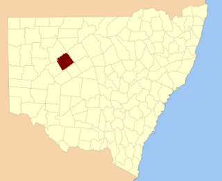
Wallandra Parish in Cobar Shire is a civil parish of Rankin County, a Cadastral division of New South Wales. The Parish is on the Darling River upstream of Wilcannia, New South Wales and is located at 30.5511°N 144.3351°E. The only town of the parish is Tilpa, New South Wales.

Cumbedore Parish, Yanda County in Bourke Shire is a civil parish of Yanda County, a cadasteral division of New South Wales.

<span class="mw-page-title-main">Dootheboy, (Yanda County)</span>

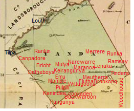
Dootheboy, in Cobar Shire is a civil parish of Yanda County a Cadastral division of New South Wales.

Bright Parish, in Cobar Shire is a civil parish of Yanda County, a Cadastral division of New South Wales.

Kenindee Parish, in Cobar Shire is a civil parish of Yanda County a Cadastral division of New South Wales.

Kenindee Parish, in Cobar Shire is a civil parish of Yanda County a Cadastral division of New South Wales.

Emu Parish, in Cobar Shire is a civil parish of Yanda County a Cadastral division of New South Wales.

<span class="mw-page-title-main">Dunlop Parish (Yanda County)</span> Place in New South Wales, Australia

Dunlop Parish is a civil parish, of Yanda County, a cadasteral division of New South Wales; a Cadastral division of New South Wales.

Gundabooka Parish is a civil parish, of Yanda County, a cadasteral division of New South Wales; a Cadastral division of New South Wales.

Yanda Parish, is a civil parish, of Yanda County, a cadasteral division of New South Wales; a Cadastral division of New South Wales.

Loftus Parish is a civil parish of Cowper County, New South Wales; a Cadastral division of New South Wales. located at 30°13'05.0"S 146°27'57.0"E between Byrock, New South Wales and Bourke, New South Wales.

References

  1. Map of the County of Yanda, Western Division, NSW 1918.
  2. [cartographer] C.A. Orwin, [https://nla.gov.au/nla.obj-233873384/view Map of the County of Rankin : Western Division, Land Districts of Bourke, Cobar and Wilcannia, N.S.W. 1912 (New South Wales. Department of Lands Title, Sydney N.S.W. 1914).
  3. "Rankin". Geographical Names Register (GNR) of NSW. Geographical Names Board of New South Wales . Retrieved 4 August 2013. OOjs UI icon edit-ltr-progressive.svg
  4. The New atlas of Australia (John Sands, 1886) map 24.
  5. Yanda County, GEOGRAPHICAL NAMES REGISTER EXTRACT.
  6. / The New atlas of Australia, (John Sands, 1886), map 24.
  7. [cartographer] C.A. Orwin, [https://nla.gov.au/nla.obj-233873384/view Map of the County of Rankin : Western Division, Land Districts of Bourke, Cobar and Wilcannia, N.S.W. 1912 (New South Wales. Department of Lands Title, Sydney N.S.W. 1914).
  8. "Rankin". Geographical Names Register (GNR) of NSW. Geographical Names Board of New South Wales . Retrieved 4 August 2013. OOjs UI icon edit-ltr-progressive.svg
  9. The New atlas of Australia (John Sands, 1886) map 24.
  10. Peel, M. C.; Finlayson, B. L.; McMahon, T. A. (2007). "Updated world map of the Köppen–Geiger climate classification". Hydrol. Earth Syst. Sci. 11: 1633–1644. doi: 10.5194/hess-11-1633-2007 . ISSN   1027-5606.(direct: Final Revised Paper)
  11. Norman Tindale's Catalogue of Australian Aboriginal Tribes
  12. Aboriginal Australia Map, David Horton (ed.), 1994 published in The Encyclopedia of Aboriginal Australia by AIATSIS.