
The Ferrymead Railway is a New Zealand heritage railway built upon the track formation of New Zealand's first public railway, from Ferrymead to Christchurch, which opened on 1 December 1863. On the opening of the line to Lyttelton on 9 December 1867, the Ferrymead Railway became the Ferrymead Branch and was closed shortly thereafter. In 1964, rail enthusiasts began relaying track on the historic formation and the new 3 ft 6 in narrow gauge. Ferrymead Railway officially reopened in 1977. It now operates steam, diesel and electric trains regularly and is recognised as one of the most significant rail preservation sites in New Zealand.

The Basin Reserve, also known as the Cello Basin Reserve for sponsorship reasons, and commonly referred to as the Basin, is a cricket ground in Wellington, New Zealand. It is used for Test matches, and is the main home ground of the Wellington Firebirds first-class team. The Basin Reserve is the only cricket ground to have listed status with Heritage New Zealand, in recognition of being the oldest first-class cricket ground in the country. Historically, the ground has also been used for events other than cricket, such as association football matches, concerts and cultural events.

The Waimakariri River is one of the largest rivers in Canterbury, on the eastern coast of New Zealand's South Island. It flows for 151 kilometres (94 mi) in a generally southeastward direction from the Southern Alps across the Canterbury Plains to the Pacific Ocean.
The Canterbury Museum is a museum located in the central city of Christchurch, New Zealand, in the city's Cultural Precinct. The museum was established in 1867 with Julius von Haast – whose collection formed its core – as its first director. The building is registered as a "Historic Place – Category I" by Heritage New Zealand.

The Sign of the Takahe is a neo-Gothic style historic building in Christchurch, New Zealand. It is currently leased from Christchurch City Council and run as a pop in cafe, bar, and now focuses on wedding & functions.

Hagley Oval is a cricket ground in Hagley Park in the central city of Christchurch, New Zealand. The first recorded match on the ground was in 1867, when Canterbury cricket team hosted Otago cricket team. Canterbury used the ground infrequently from then through until the 1920s, but hardly stopped during World War I.

John Anderson was the second Mayor of Christchurch in New Zealand 1868–1869, and a successful businessman. He had a close connection with three buildings that have later received Category I heritage registrations by Heritage New Zealand. Two of these buildings were demolished following the February 2011 Christchurch earthquake.

The Lyttelton Timeball Station is a heritage-registered time ball station and prominent local landmark in Lyttelton, New Zealand. The original station was significantly damaged by a series of earthquakes and aftershocks in 2010 and 2011, and finally collapsed on 13 June 2011 after a magnitude 6.4 aftershock. The tower was subsequently reconstructed, reopening in November 2018.

Clarendon Tower was a high rise building on Worcester Street at Oxford Terrace in the Christchurch Central City, New Zealand. Built on the site of the former Clarendon Hotel, the façade of the historic building was kept in the redevelopment and was protected by the New Zealand Historic Places Trust as a Category II heritage structure. Following damage from the February 2011 Christchurch earthquake, the 17-storey building has been demolished.
Mandeville Sports Centre is a sports ground and community park in Mandeville North, Canterbury, New Zealand. The park is home to 13 clubs facilitating archery, equestrian events, netball, rugby, tennis, cricket, dog clubs, bowls and squash. The ground held a single List A match in the 1990/91 Shell Cup when Canterbury played Wellington, which resulted in a 19 run victory for Wellington. A number of other sports are played at the complex.
Dudley Park is a cricket ground in Rangiora, Canterbury, New Zealand. The park precincts, situated between Church and White Streets, also include an aquatic centre, netball courts and hockey ground. It was the main cricket ground in Rangiora between 1929 and 2004.
Rangiora Recreation Ground is a cricket ground in Rangiora, Canterbury, New Zealand.

Cranmer Square is an urban park in central Christchurch, New Zealand. It is located 800 metres (870 yd) northwest of the city's centre, Cathedral Square. The major arterial route of Montreal Street skirts the edge of the square. The square is grassed and crossed by concrete paths and edged by mature trees. It covers an area of 1.9 hectares.
Cracroft is a south-west suburb of Christchurch, Canterbury, New Zealand.
The Christchurch Club is a historic private members' club in the central city of Christchurch, New Zealand. The older of the two Christchurch clubs, it was founded by rural landholders in 1856; the rival organisation, the Canterbury Club, was a breakaway that was founded by urban professionals in 1872.
The Canterbury Club is a historic gentlemen's club in the central city of Christchurch, New Zealand. It was founded by urban professionals in 1872 as a breakaway club from the Christchurch Club, which had been set up by large rural landholders in 1856.
Shand's Emporium, previously known as Gee's, is a historic building in the central city of Christchurch, New Zealand. One of the oldest commercial buildings to remain from the time Christchurch was founded, it was relocated in June 2015 from its original location in Hereford Street to Manchester Street, where it is placed adjacent to another heritage building, The Octagon.

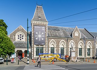
The Registry Building belongs to the Christchurch Arts Centre in the Christchurch Central City of Christchurch, New Zealand. It is covered by a Category I registration by Heritage New Zealand that is separate to the Category I registration that covers the buildings in the western part of the block, and the Category II registration that applies to the former Student Union building. Designed by Collins and Harman, the Registry Building was constructed in 1916 and an extension was added ten years later. After the 2011 Christchurch earthquake, 22 of the historic buildings were red stickered. The Registry Building was the first one to be restored, and it reopened in July 2013.

Ivey Hall is a historic building on the campus of Lincoln University in New Zealand. It is registered as a Category I structure by Heritage New Zealand.

Gloucester Street is a major urban street in central Christchurch in the South Island of New Zealand. It runs for approximately 4.9 kilometres (3.0 mi) from a junction with Rolleston Avenue at its western end, directly opposite Christ's College, to the suburbs of Linwood and Avonside in the east. For the majority of its length it runs due west-east, with the section from the central city's eastern edge to Linwood veering to the northeast.
