
The Philippines is an archipelago that comprises 7,641 islands with a total land area of 300,000 square kilometers (115,831 sq mi). It is the world's fifth largest island country. The eleven largest islands contain 95% of the total land area. The largest of these islands is Luzon at about 105,000 square kilometers (40,541 sq mi). The next largest island is Mindanao at about 95,000 square kilometers (36,680 sq mi). The archipelago is around 800 kilometers (500 mi) from the Asian mainland and is located between Taiwan and Borneo.
Northern Samar, officially the Province of Northern Samar, is a province in the Philippines located in the Eastern Visayas region. Its capital is Catarman and is located at the northern portion of the island of Samar. Bordering the province to the south are the provinces of Samar and Eastern Samar. To the northwest, across the San Bernardino Strait is Sorsogon; to the east is the Philippine Sea and to the west is Samar Sea.

Santo Niño, officially the Municipality of Santo Niño, is a 5th class municipality in the province of Samar, Philippines. According to the 2020 census, it has a population of 12,519 people.

San Jose, officially the Municipality of San Jose, is a 5th class municipality in the province of Northern Samar, Philippines. According to the 2020 census, it has a population of 17,641 people.
Mawson Peninsula is a high, narrow, ice-covered peninsula on the George V Coast, on the west side of the Slava Ice Shelf, Antarctica, terminating in Cape Hudson. It extends for over 30 nautical miles (56 km) in a northwesterly direction. The peninsula was photographed from the air by U.S. Navy Operation Highjump, 1946–47, and was sketched and photographed by Phillip Law of the Australian National Antarctic Research Expeditions who flew along it to its northern end in February 1959. It was named by the Antarctic Names Committee of Australia for Sir Douglas Mawson.

Cape Flying Fish is an ice-covered cape which forms the western extremity of Thurston Island. It was discovered by Richard E. Byrd and members of the US Antarctic Program in a flight from the USS Bear in February 1940. It was named by the Advisory Committee on Antarctic Names for the United States Exploring Expedition ship USS Flying Fish, commanded by William M. Walker, which reached a point within 125 miles of this cape; the ship's position on the morning of March 23, 1839, was 70°0′S100°16′W.

The USS Albireo (AK-90) was a Crater-class cargo ship in the service of the US Navy in World War II and manned by a US Coast Guard crew. She was the only ship of the Navy to have borne this name. She is named after Albireo, a star in the constellation of Cygnus.

Butuan Bay is a bay and extension of the Bohol Sea or Mindanao Sea, in the northeast section of Mindanao in the Philippines. Its main river source is the Agusan River, which empties into the bay at the coastal city of Butuan. Butuan Bay is completely contained with the Agusan del Norte province.
Debenham Glacier is a glacier flowing into the northern part of Wilson Piedmont Glacier on the coast of Victoria Land. It was first mapped by the British National Antarctic Expedition, 1901–04, and was named by the British Antarctic Expedition, 1910–13, for Frank Debenham, a geologist with the expedition and Director of the Scott Polar Research Institute, 1925–48.
Balchen Glacier is a crevassed glacier in Antarctica, flowing west to Block Bay between the Phillips Mountains and the Fosdick Mountains in Marie Byrd Land. It was discovered on December 5, 1929, by the Byrd Antarctic Expedition and named by Richard E. Byrd for Bernt Balchen, chief pilot of the expedition.
Black Thumb is a mountain, 1,190 metres (3,900 ft) high, with notched and precipitous sides, standing between Romulus Glacier and Bertrand Ice Piedmont on the west coast of Graham Land. It was charted and named by the British Graham Land Expedition under John Rymill, 1934–37.
Mount Edgell is a mountain, 1,675 metres (5,500 ft) high, rising eastward of Cape Jeremy, the east side of the north entrance to George VI Sound, on the west coast of the Antarctic Peninsula. It was discovered by the French Antarctic Expedition of 1908–10 under Jean-Baptiste Charcot. Charcot saw it first from a great distance and thinking it to be an island, he named it "Ile Gordon Bennett" for James Gordon Bennett, Jr. of the New York Herald, who gave financial aid to the expedition. The British Graham Land Expedition under John Rymill, surveying this area in 1936–37 and finding no island, applied the name Mount Edgell to the feature now recognized as Charcot's "Ile Gordon Bennett." The name Mount Edgell, after Sir John Augustine Edgell, Hydrographer of the Navy from 1932–45, has since become established through international usage.
The Havre Mountains are a large group of mountains forming the northwestern extremity of Alexander Island, Antarctica, extending 20 nautical miles (37 km) in an east–west direction between Cape Vostok and the Russian Gap. They were first seen in 1821 by a Russian expedition under Fabian Gottlieb von Bellingshausen and re-sighted by the Belgian Antarctic Expedition, 1897–99. They were roughly charted by the French Antarctic Expedition, 1908–10, under Jean-Baptiste Charcot, who named them for Le Havre, the French port from which the Pourquol Pas? sailed in 1908. The mountains were mapped in detail from air photos taken by the Ronne Antarctic Research Expedition, 1947–48, by D. Searle of the Falkland Islands Dependencies Survey in 1960.
Seraph Bay is an open bay about 15 nautical miles (28 km) wide, formed at the southeast end of Thurston Island. It is bounded by Cape Annawan on the northwest, Abbot Ice Shelf on the southwest and Dustin Island on the southeast. It was discovered by members of the United States Antarctic Service in flights from the ship Bear in February 1940. The bay was more accurately delineated by the U.S. Navy Bellingshausen Sea Expedition in February 1960. It was named by the Advisory Committee on Antarctic Names for the brig Seraph of Stonington, CT, which in 1830, under Captain Benjamin Pendleton, sailed westward from the South Shetland Islands, reaching as far as 101W, south of 60S.
Abag Bay is a bay in Mindanao, Philippines. Abag is bight, which also contains the village of Kalaguhan.

Kamen Ariy, or Ary Rock is a small islet of the Commander Islands in the North Pacific Ocean, east of the Kamchatka Peninsula in Eastern Russia. These islands belong to the Kamchatka Krai of the Russian Federation. Kamen Ariy is about 8 km (5 mi) west of Tufted Puffin Rock and consists of two rocks. The northern rock is pointed and reaches a height of 45 m (150 ft). The southern rock is much flatter and only reaches a height of 2.1 m.
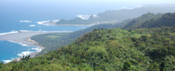

 View of Cape Espiritu Santo from the Pacific Ocean
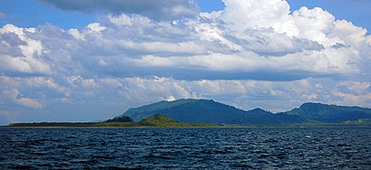
 Cape Espiritu Santo falls

