
The Strait of Juan de Fuca is a body of water about 96 miles long that is the Salish Sea's main outlet to the Pacific Ocean. The international boundary between Canada and the United States runs down the centre of the Strait.

Kodiak Island Borough is a borough in the U.S. state of Alaska. At the 2020 census, the population was 13,101, down from 13,592 in 2010. The borough seat is Kodiak.

Katmai National Park and Preserve is an American national park and preserve in southwest Alaska, notable for the Valley of Ten Thousand Smokes and for its brown bears. The park and preserve encompass 4,093,077 acres, which is between the sizes of Connecticut and New Jersey. Most of the national park is a designated wilderness area. The park is named after Mount Katmai, its centerpiece stratovolcano. The park is located on the Alaska Peninsula, across from Kodiak Island, with headquarters in nearby King Salmon, about 290 miles (470 km) southwest of Anchorage. The area was first designated a national monument in 1918 to protect the area around the major 1912 volcanic eruption of Novarupta, which formed the Valley of Ten Thousand Smokes, a 40-square-mile (100 km2), 100-to-700-foot-deep pyroclastic flow. The park includes as many as 18 individual volcanoes, seven of which have been active since 1900.

Alaska is a 1988 historical novel by James A. Michener. Like other Michener titles, Alaska spans a considerable amount of time, traced through the gradual interlinking of several families.

Cook Inlet stretches 180 miles (290 km) from the Gulf of Alaska to Anchorage in south-central Alaska. Cook Inlet branches into the Knik Arm and Turnagain Arm at its northern end, almost surrounding Anchorage. On its southern end, it merges with Shelikof Strait, Stevenson Entrance, Kennedy Entrance and Chugach Passage.

Kodiak Island is a large island on the south coast of the U.S. state of Alaska, separated from the Alaska mainland by the Shelikof Strait. The largest island in the Kodiak Archipelago, Kodiak Island is the second largest island in the United States and the 80th largest island in the world, with an area of 3,595.09 sq mi (9,311.2 km2), slightly larger than Cyprus. It is 160 km long and in width ranges from 16 to 97 kilometers. Kodiak Island is the namesake for Kodiak Seamount, which lies off the coast at the Aleutian Trench. The largest community on the island is the city of Kodiak, Alaska.
Shelikof Strait is a strait on the southwestern coast of the U.S. state of Alaska between the Alaska mainland to the west and Kodiak and Afognak islands to the east.
Kachemak Bay is a 40-mi-long (64 km) arm of Cook Inlet in the U.S. state of Alaska, located on the southwest side of the Kenai Peninsula. The communities of Homer, Halibut Cove, Seldovia, Nanwalek, Port Graham, and Kachemak City are on the bay as well as three Old Believer settlements in the Fox River area, Voznesenka, Kachemak Selo, and Razdolna.
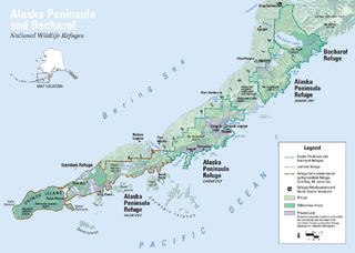
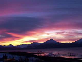
The Alaska Peninsula is a peninsula extending about 497 mi (800 km) to the southwest from the mainland of Alaska and ending in the Aleutian Islands. The peninsula separates the Pacific Ocean from Bristol Bay, an arm of the Bering Sea.

The Farallon Steamship Disaster was the wreck of a wooden Alaska Steamship Company passenger liner, SS Farallon, that hit Black Reef in Cook Inlet in the Territory of Alaska on 5 January 1910. All on board evacuated to a nearby island, where most had to survive for a month in a mid-winter climate before they were rescued. Six other survivors survived an attempt to row across Shelikof Strait in search of rescue for the stranded men.

Southwest Alaska is a region of the U.S. state of Alaska. The area is not exactly defined by any governmental administrative region(s); nor does it always have a clear geographic boundary.
Sitkalidak Island is an island in the western Gulf of Alaska in the Kodiak Island Borough of the state of Alaska, United States. It lies just off the southeast shore of Kodiak Island, across the Sitkalidak Strait from the city of Old Harbor. The island has a land area of 300 square kilometers (120 sq mi) and no resident population.
Pleasant Island is the largest island in the Icy Strait between northern Chichagof Island and the mainland of the Alaska Panhandle. It lies southeast of the mainland city of Gustavus and southwest of the mainland community of Excursion Inlet. Pleasant Island has a land area of 49.192 km², had no population at the 2000 census, Colter Barnes is the only person who lives here.
The Spiridon Peninsula is a mountainous peninsula on the northwest side of Kodiak Island, Alaska on the Shelikof Strait situated between Uganik Bay and Uyak Bay. Major promontories are Miners Point, Cape Ugat and Cape Kuliuk. Cape Ugat is the closest point on Kodiak Island to mainland Alaska.

USCGC Confidence (WMEC-619) is a United States Coast Guard medium endurance cutter.
The wildlife of Alaska is both diverse and abundant. The Alaskan Peninsula provides an important habitat for fish, mammals, reptiles, and birds. At the top of the food chain are the bears. Alaska contains about 70% of the total North American brown bear population and the majority of the grizzly bears, as well as black bears and Kodiak bears. In winter, polar bears can be found in the Kuskokwim Delta, St. Matthew Island, and at the southernmost portion of St. Lawrence Island. Other major mammals include moose and caribou, bison, wolves and wolverines, foxes, otters and beavers. Fish species are extensive, including: salmon, graylings, char, rainbow and lake trout, northern pike, halibut, pollock, and burbot. The bird population consists of hundreds of species, including: bald eagles, owls, falcons, ravens, ducks, geese, swans, and the passerines. Sea lions, seals, sea otters, and migratory whales are often found close to shore and in offshore waters. The Alaskan waters are home to two species of turtles, the leatherback sea turtle and the green sea turtle. Alaska has two species of frogs, the Columbia spotted frog and wood frog, plus two introduced species, the Pacific tree frog and the red-legged frog. The only species of toad in Alaska is the western toad. There are over 3,000 recorded species of marine macroinvertebrates inhabiting the marine waters, the most common being the various species of shrimp, crab, lobster, and sponge.

Raspberry Island is an island of the Kodiak Archipelago located in the Gulf of Alaska in the U.S. state of Alaska. It is located two miles northwest of Whale Island, and just across the mile-wide Raspberry Strait from the southwestern end of Afognak. The island is separated from Kodiak Island by the Kupreanof Strait, with the Shelikof Strait to the northwest. Raspberry Island is 18 miles (29 km) long with a width that varies from 3 miles (4.8 km) to 8 miles (12.9 km). The highest point on the island is 3,300 ft.

The Alaska Peninsula montane taiga is a taiga and boreal forests ecoregion, located in Alaska, and defined by the World Wildlife Fund (WWF) categorization system.
Kootznahoo Inlet is located on the eastern shore of Chatham Strait in the U.S. state of Alaska. Comprising an area of about 15 square miles (39 km2), it is an intricate group of narrow passages, lagoons, and bays, having its entrance 3 miles (4.8 km) north of Killisnoo. Kootznahoo, which means bear fortress, is also the name given by the Tlingit to mean Admiralty. The Kootznoowoo Wilderness also of the Admiralty Island covers some of the largest reserve areas covering about 1 million acres. The island is inhabited by about 1500 brown bears, the largest number recorded anywhere on the earth.
Uganik Bay is a bay on the north coast of Kodiak Island, Alaska, extending southeast off Shelikof Strait. The community of Uganik is found at the west shore of the northeast arm of the bay.