
The Gulf of St. Lawrence fringes the shores of the provinces of Quebec, New Brunswick, Nova Scotia, Prince Edward Island, Newfoundland and Labrador, in Canada, plus the islands Saint-Pierre and Miquelon, possessions of France, in North America.

The following lists include extreme and significant points of the geography of Canada.

Fortune Bay—Cape La Hune is a provincial electoral district for the House of Assembly of Newfoundland and Labrador, Canada. When created in 1975 it was called Fortune-Hermitage. As of 2011, there are 6,053 eligible voters living within the district.
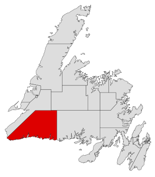
Burgeo-La Poile is a provincial electoral district for the House of Assembly of Newfoundland and Labrador, Canada. As of 2011, there are 7,527 eligible voters living within the district. The district was first created when Newfoundland joined confederation in 1949 as Burgeo and La Poile, and existed until 1975. It was recreated in 1995 following a reduction in the number of seats in the House of Assembly from 52 to 48, forming from the amalgamation of the former districts of La Poile and Burgeo-Bay D'Espoir.

Cape Ray is a headland located at the southwestern extremity of the island of Newfoundland in the Canadian province of Newfoundland and Labrador.
Cape Ray is a local service district and designated place in the Canadian province of Newfoundland and Labrador. It is on the southwest coast of the island of Newfoundland.
Bay d'Espoir is an arm of Hermitage Bay in the Gulf of Saint Lawrence, located on the south coast of Newfoundland. Communities in Bay d'Espoir include: Milltown-Head of Bay d'Espoir, Morrisville, St. Alban's, St. Joseph's Cove, St. Veronica's and Miawpukek. The Miawpukek First Nation reserve of Samiajij Miawpukek is located in Bay d'Espoir.
Tracey Perry is a Canadian politician who served in the Newfoundland and Labrador House of Assembly from 2007 to 2019, representing the district of Fortune Bay-Cape La Hune as a member of the Progressive Conservative Party. She previously served as the Parliamentary Assistant to Premier Paul Davis.

St. Jacques-Coomb's Cove is a town in the Canadian province of Newfoundland and Labrador. The town had a population of 546 in the Canada 2021 Census. It is located on the south coast of the island of Newfoundland on the north side of Fortune Bay, on the southern tip of the Connaigre Peninsula in what is now known as the Coast of Bays Region. The town consists of six communities, St. Jacques, English Harbour West, Mose Ambrose, Boxey, Coomb's Cove, and Wreck Cove, all nestled within the inlets along the coast. They all had their beginnings in the fisheries and the fisheries have always been the mainstay of employment in the communities. In recent years aquaculture was introduced in the area, providing employment for its residents.
Lintlaw is a village in the Canadian province of Saskatchewan within the Rural Municipality of Hazel Dell No. 335 and Census Division No. 9. The village is located at the intersection of Highway 49 and Highway 617, 142 km northwest of the City of Yorkton.
Parsons Harbour or New Harbour is located east of Cape La Hune on Hermitage Bay. The Post Office was established in 1951 on May 25. The first Postmaster was Freeman Foss.
The headland of Cape La Hune is a remote point of land on the south coast of the island of Newfoundland in the Canadian province of Newfoundland and Labrador. The Cape is the location of the provincial electoral district of Fortune Bay-Cape La Hune.
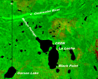
Black Point is a northern hamlet in Saskatchewan situated on the southern shore of Lac La Loche close to the northern village of La Loche. It is accessible by road by Highway 956 which is off Highway 155.
Oliver Langdon is an educator and former political figure in Newfoundland and Labrador. He represented Fortune Bay-Cape La Hune in the Newfoundland and Labrador House of Assembly from 1989 to 2007 as a Progressive Conservative and then Liberal member.

The borders of the oceans are the limits of Earth's oceanic waters. The definition and number of oceans can vary depending on the adopted criteria. The principal divisions of the five oceans are the Pacific Ocean, Atlantic Ocean, Indian Ocean, Southern (Antarctic) Ocean, and Arctic Ocean. Smaller regions of the oceans are called seas, gulfs, bays, straits, and other terms. Geologically, an ocean is an area of oceanic crust covered by water.
Patrick's Cove-Angels Cove is a local service district and designated place in the Canadian province of Newfoundland and Labrador. It is on the Cape Shore of the Avalon Peninsula. The area was first settled by James Coffey in the early 19th century. Coffey had moved to Newfoundland from County Waterford, Ireland to work at Placentia's Saunders and Sweetman firm. Sweetman's firm had sent some of their employees outward from Placentia to start farms in which to supply Sweetman's with produce. Coffey became the first resident of this community.
La Hune Bay is natural bay on the island of Newfoundland in the province of Newfoundland and Labrador, Canada. It is by Cape La Hune.
Division No. 1, Subdivision U is an unorganized subdivision on the Avalon Peninsula in Newfoundland and Labrador, Canada, in Division 1. It contains the unincorporated communities of Admiral's Cove, Bauline East, Bauline South, Burnt Cove, Devils Kitchen, Flat Rock, St. Michaels and Seal Cove.

Puerto Rico Highway 588 (PR-588) is a tertiary mountainous state highway in Ponce, Puerto Rico. The road is approximately 1.5 km (0.93 mi) long and is a spur of Puerto Rico Highway 504.

Elvis Loveless is a Canadian politician, who was elected as a Liberal to the Newfoundland and Labrador House of Assembly in the 2019 provincial election. He represents the electoral district of Fortune Bay-Cape La Hune in Central Newfoundland.
