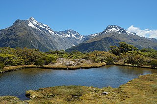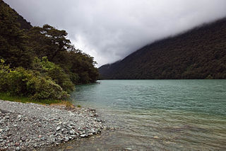
The Routeburn Track is a world-renowned, 32 km tramping (hiking) track found in the South Island of New Zealand. The track is usually completed by starting on the Queenstown side of the Southern Alps, at the northern end of Lake Wakatipu, and finishing on the Te Anau side, at the Divide, several kilometres from the Homer Tunnel to Milford Sound.

The Arrow River is a short river in Otago, New Zealand. It is a tributary of the Kawarau River, which in turn feeds into the Clutha. The town of Arrowtown lies on the Arrow. A very small amount of gold was discovered by Jack Tewa in the Arrow River in August 1862. In early October much larger finds were made by John McGregor and Peter Stewart of the McGregor and Low party and by William Fox. They disagreed over who found gold there first. It was an important part of the Central Otago Gold Rush of the 1860s.

Glenorchy is a small settlement at the northern end of Lake Wakatipu in the South Island region of Otago, New Zealand. It is approximately 45 km (28 mi) by road or boat from Queenstown, the nearest large town. There are two pubs, a café and a range of small shops in the town catering mainly to tourists but also to the small resident population. There is also a small airstrip which caters to small planes.

The Dart River, Te Awa Wakatipu in Māori language, flows through rugged forested country in the southwestern South Island of New Zealand. Partly in Mount Aspiring National Park, it flows south-west and then south for 60 kilometres (37 mi) from its headwaters in the Southern Alps and the Dart Glacier, eventually flowing into the northern end of Lake Wakatipu near Glenorchy. It was named in the 1860s by a runholder, William Gilbert Rees, who chose the name for the river's swift flow.
The Aparima River, earlier known as Jacob's River, is one of the southward-flowing braided rivers of Southland, New Zealand.

The Hollyford Track is a tramping track in New Zealand. Located at the northern edge of Fiordland, in the southwestern South Island, it is unusual among Fiordland's major tracks in that it is largely flat and accessible year-round. It follows the Hollyford River which in turn follows the course of the Hollyford Valley.

Pounamu are several types of hard and durable stone found in southern New Zealand. They are highly valued by the Māori, and objects made from pounamu play an important role in Māori culture. Geologically, pounamu are usually nephrite jade, bowenite, or serpentinite, but the Māori classify pounamu by color and appearance.

Greenstone is a suite of software tools for building and distributing digital library collections on the Internet or CD-ROM. It is open-source, multilingual software, issued under the terms of the GNU General Public License. Greenstone is produced by the New Zealand Digital Library Project at the University of Waikato, and has been developed and distributed in cooperation with UNESCO and the Human Info NGO in Belgium.

Wyndham is a rural town of 550 people in the South Island of New Zealand in the Southland region, 45 km (28 mi) east of Invercargill and 25 km (15 mi) south of Gore. The original Māori name of the locality was Mokoreta.

Tokanui is a community in the eastern portion of Southland District Council, located on the Southern Scenic Route about 55 km east of Invercargill and 109 km southwest of Balclutha, New Zealand.
The Dry Awarua River is a river of northern Fiordland, New Zealand. It rises in the McKenzie Range and flows south and then westward into the Waiuna Lagoon. The Lagoon then discharges into the Awarua River, which flows into Big Bay, also known as Awarua Bay. The Pyke - Big Bay tramping track crosses the Dry Awarua River.
The George River is a river of Fiordland, New Zealand. It rises south of Lake Beddoes and flows westward into George Sound at Anchorage Cove.
Waikiwi is a suburb of Invercargill, Southland, New Zealand. Invercargill is the southernmost city of New Zealand.

Lake Fergus is a lake in the South Island of New Zealand, located at 44°50′42″S168°6′40″E.

Arthurs Point is a suburb of Queenstown in the South Island of New Zealand. It is situated near Queenstown Hill and Bowen Peak and is not far from central Queenstown. Another distinctive aspect for the area is that the Shotover Jet company operates jetboats on the Shotover River which passes under the Edith Cavell bridge.

The Routeburn River, also known as the Route Burn, is a river in New Zealand. It is a short stony river that flows for some 15 kilometres into the Dart River in the South Island. The Routeburn River flows alongside a section of the Routeburn Track. The upper reaches of the river are found in the Routeburn North Branch and leave the Routeburn Track around the Routeburn Flat Hut area.

The Humboldt Mountains or Humboldt Range are one of the many ranges which make up the Southern Alps in the South Island of New Zealand. They lie to the northwest of Lake Wakatipu in the Otago Region. Parts of the range lie within Fiordland National Park, and they form the southern extremity of Mount Aspiring National Park. The range was named by early explorer James McKerrow, and like many geographic features worldwide, it was named in honour of notable scientist Alexander von Humboldt.


