The geography of France consists of a terrain that is mostly flat plains or gently rolling hills in the north and west and mountainous in the south and the east.

Slivník is a village and municipality in the Trebišov District in the Košice Region of eastern Slovakia.

Lastovce is a village and municipality in the Trebišov District in the Košice Region of eastern Slovakia.

This is a list of the extreme points of Azerbaijan, the points that are farther north, south, east or west than any other location.

Nižný Lánec is a village and municipality in Košice-okolie District in the Kosice Region of eastern Slovakia.

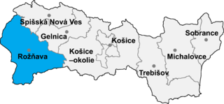
Čučma is a village and municipality in the Rožňava District in the Košice Region of eastern Slovakia.
La Hiniesta, 7 km from the capital, Zamora, of currently belongs to the province of the same name in the Comunidad Autónoma de Castilla-León in Spain. Uts population was 364 inhabitants. Its major attraction is the Iglesia de Santa María, a church that King Sancho IV of Leon ordered built in the honor of the Virgin, who appeared to him in una cacería entre unas hiniestas o retamas, from whence it gets its more frequently-used name, Virgen de la Hiniesta. Among its products más destacados, están los Quesos, de una exquisite purity, of both natural and artisanal manufacture.

Nohurdüzü is a village in the Quba Rayon of Azerbaijan. The village forms part of the municipality of Yerfi.

Dzhibir-Kazmalary is a village in the Qusar Rayon of Azerbaijan.

Düztahiroba is a village in the Khachmaz Rayon of Azerbaijan. The village forms part of the municipality of Yalama.

Barkhalbina is a village in the Zaqatala Rayon of Azerbaijan.
Klinbi is a village in the municipality of Hamoşam in the Astara Rayon of Azerbaijan.
Ülgüc is a village and municipality in the Agsu Rayon of Azerbaijan. It has a population of 515.
Minaxür is a village and the least populous municipality in the Qusar Rayon of Azerbaijan. It has a population of 242.
Urvaoba is a village in the municipality of Urva in the Qusar Rayon of Azerbaijan.

Hollóháza is a village in Borsod-Abaúj-Zemplén County in northeastern Hungary. The village is famous for its porcelain made here.
Kéked is a village in Borsod-Abaúj-Zemplén County in northeastern Hungary.
Komjáti is a village in Borsod-Abaúj-Zemplén County in northeastern Hungary.
Vágáshuta is a village in Borsod-Abaúj-Zemplén County in northeastern Hungary.
Veske is a village in Saaremaa Parish, Saare County, on the island of Saaremaa Estonia.


