Carey Mission

Last updated
Carey Mission School Site is west of Niles, Michigan, on Niles Buchanan Rd. Carey Misson Marker.jpg
Carey Mission School Site is west of Niles, Michigan, on Niles Buchanan Rd.

Carey Mission was established in December 1822 by Baptist missionary Isaac McCoy among the Potawatomi tribe of American Indians on the St. Joseph River near Niles, Michigan, United States. It was named for English Baptist missionary William Carey. Its official nature and reputation made it a headquarters for settlers and an edge of the American frontier. [1]

Contents

History

Lewis Cass, the second governor of the Michigan Territory, signed the 1821 Treaty of Chicago on August 29, 1821, with the chiefs of the Ottawa, Chippewa, and Potawatomi nations. The Potawatomi agreed to cede to the United States all the territory lying west and north of the St. Joseph River, [2] and the United States agreed to provide funds for a blacksmith and a teacher, to reside on "one mile square on the south side of the St. Joseph" within a tract that the Potawatomis had reserved for their villages. McCoy, who had previously traveled to Detroit and petitioned Cass to provide funds for Indian missions in the 1821 Treaty, secured the position of teacher. [3]

In December 1822, a 32-person party consisting of McCoy, his family, and a group of Indians who had elected to accompany them, departed for southwestern Michigan. [3] They emigrated from the vicinity of Fort Wayne, Indiana, to a point about one mile west of the present city of Niles, and by the following year they had built six mission houses. [1]

The first school at Carey was opened on January 27, 1823, and originally had 30 Indian pupils. [3] An expedition that visited the mission in June 1823 reported, "The school consists of from forty to sixty children, of which fifteen are females. They are either children of Indians, or half-breed descendants of French and Indian parents; there being about an equal number of each. It is contemplated that the school will soon be increased to one hundred." [4]

In 1824, an agent for Cass reported that the Carey Mission was "a colony firmly settled, numerous, civilized and happy". Fifty densely wooded acres had been cleared and fenced, and workers had raised large amounts of corn, oats, and potatoes. By 1826, over 200 acres (0.81 km2) of land had been cleared, and 58 acres (230,000 m2) had been planted. [1]

The mission became a waystation for white settlers of the Michigan Territory. McCoy realized that they would soon supplant the native Indians. He wrote: "Our location was so remote from the settlements of white people when we first made it, and the inconveniences of reaching and residing at it so great, that we hoped, at that time, to be able to push forward the work of civilization to a state not much liable to injury by the proximity of white population, before we should be crowded by it." [5]

During the period from 1827 to 1829, southwestern Michigan began to be actively settled, and the Carey Mission declined, [1] as a result of the U.S. policy of Indian removal. In 1827, in the Treaty of St. Joseph, the Potawatomi tribe ceded some of their reserved lands in southwestern Michigan. The treaty stated that its purpose was "to consolidate some of the dispersed bands of the Potawatamie Tribe in the Territory of Michigan at a point removed from the road leading from Detroit to Chicago, and as far as practicable from the settlements of the Whites". [6] In 1829, McCoy removed to the Thomas station, another mission he had established near the Grand River. The only missionary who remained at Carey was Robert Simerwell. [7] With passage of the Indian Removal Act in 1830, the school at Carey Mission was discontinued. In 1831, McCoy led several of the Potawatomi to a new mission in Kansas.

The modern site consists only of a historical marker placed by the Daughters of the American Revolution, near residential streets named Christiana Drive, Lykins Lane, Isaac McCoy Drive, and Carey Mission Road. [8]

Reception

Carey Mission was called the "point from which the American frontier was extended". [9]

The founding of the Carey Mission was, according to Michigan jurist Nathaniel Bacon, "the pioneer step in the way of settlement". Bacon remarked that in 1822, when the mission was established, the region was considered by European settlers to be dangerous and hostile. Within recent memory were the Battle of Tippecanoe in Indiana and the Battle of Fort Dearborn in Illinois. "Emigration had in a great measure stopped. Very few dared to venture beyond the older settlements, until McCoy boldly entered into the heart of the Indian country, and began his mission school among the Pottawottomies who dwelt on the river St. Joseph. The fact was soon made known throughout Indiana and Ohio, and at once adventurers began to prepare to follow the example of the missionary, who had led the way." [2] Several former students, including John Tecumseh Jones, became leaders in the American West. [10]

See also

Related Research Articles

<span class="mw-page-title-main">Berrien County, Michigan</span> County in Michigan, United States

Berrien County is a county in the U.S. state of Michigan. It is located at the southwest corner of the state's Lower Peninsula, located on the shore of Lake Michigan and sharing a land border with Indiana. As of the 2020 Census, the population was 154,316. The county seat is St. Joseph.

<span class="mw-page-title-main">Potawatomi</span> Native American people of the Great Plains

The Potawatomi, also spelled Pottawatomi and Pottawatomie, are a Native American people of the Great Plains, upper Mississippi River, and western Great Lakes region. They traditionally speak the Potawatomi language, a member of the Algonquian family. The Potawatomi call themselves Neshnabé, a cognate of the word Anishinaabe. The Potawatomi are part of a long-term alliance, called the Council of Three Fires, with the Ojibwe and Odawa (Ottawa). In the Council of Three Fires, the Potawatomi are considered the "youngest brother". Their people are referred to in this context as Bodéwadmi, a name that means "keepers of the fire" and refers to the council fire of three peoples.

<span class="mw-page-title-main">Michigan Territory</span> Territory of the US, 1805–1837

The Territory of Michigan was an organized incorporated territory of the United States that existed from June 30, 1805, until January 26, 1837, when the final extent of the territory was admitted to the Union as the State of Michigan. Detroit was the territorial capital.

<span class="mw-page-title-main">Westport, Kansas City, Missouri</span> Neighborhood in Missouri, United States

Westport is a historic neighborhood and a main entertainment district in Kansas City, Missouri.
<span class="mw-page-title-main">Louis Campau</span>

Louis Campau, also spelled Louis Campeau, was an important figure in the early settlement of Saginaw and Grand Rapids - two important Michigan cities in which he had established trading posts. Campau was also involved in negotiations between the local Native Americans and the federal government, including the Treaty of Detroit signed in 1855 by the local chief, Cobmoosa.

<span class="mw-page-title-main">Treaty of St. Mary's (1818)</span> 1818 treaties between the United States and Native Americans

The Treaty of St. Mary's may refer to one of six treaties concluded in fall of 1818 between the United States and Natives of central Indiana regarding purchase of Native land. The treaties were

<span class="mw-page-title-main">Treaty of Fort Meigs</span> 1817 treaty between the United States and Native Americans

The Treaty of Fort Meigs, also called the Treaty of the Maumee Rapids, formally titled, "Treaty with the Wyandots, etc., 1817", was the most significant Indian treaty by the United States in Ohio since the Treaty of Greenville in 1795. It resulted in cession by bands of several tribes of nearly all their remaining Indian lands in northwestern Ohio. It was the largest wholesale purchase by the United States of Indian land in the Ohio area. It was also the penultimate one; a small area below the St. Mary's River and north of the Greenville Treaty Line was ceded in the Treaty of St. Mary's in 1818.

<span class="mw-page-title-main">Isaac McCoy</span> American missionary (1784–1846)

Isaac McCoy was an American pioneer and Baptist missionary among the Native Americans in what became the states of Indiana, Michigan, Missouri, and Kansas.

Note: There are multiple treaties referred to as Treaty with the Potawatomi. See Treaty with the Potawatomi for others.

<span class="mw-page-title-main">Yellow River (Indiana)</span> River in Indiana, United States

The Yellow River is a 62.3-mile-long (100.3 km) tributary of the Kankakee River in the Central Corn Belt Plains ecoregion, located in northern Indiana in the United States. Via the Kankakee and Illinois rivers, it is part of the watershed of the Mississippi River, draining an area of 427 square miles (1,110 km2).

<span class="mw-page-title-main">Johnston Lykins</span> 2nd mayor of Kansas City, Missouri (1854-1855)

Johnston Lykins was a pioneering Baptist missionary to Native American tribes, and a founding civic booster in the frontier boomtowns of West Port and Kansas, Missouri, which combined and became Kansas City, Missouri.
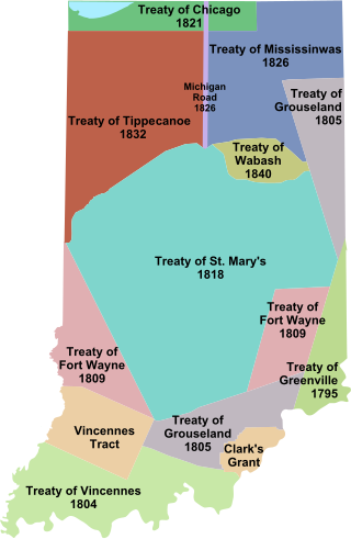
<span class="mw-page-title-main">Indian removals in Indiana</span> Removal of native tribes from Indiana

Indian removals in Indiana followed a series of the land cession treaties made between 1795 and 1846 that led to the removal of most of the native tribes from Indiana. Some of the removals occurred prior to 1830, but most took place between 1830 and 1846. The Lenape (Delaware), Piankashaw, Kickapoo, Wea, and Shawnee were removed in the 1820s and 1830s, but the Potawatomi and Miami removals in the 1830s and 1840s were more gradual and incomplete, and not all of Indiana's Native Americans voluntarily left the state. The most well-known resistance effort in Indiana was the forced removal of Chief Menominee and his Yellow River band of Potawatomi in what became known as the Potawatomi Trail of Death in 1838, in which 859 Potawatomi were removed to Kansas and at least forty died on the journey west. The Miami were the last to be removed from Indiana, but tribal leaders delayed the process until 1846. Many of the Miami were permitted to remain on land allotments guaranteed to them under the Treaty of St. Mary's (1818) and subsequent treaties.

Jotham Meeker was a Baptist missionary, printer, who lived and proselytized among various Native American peoples, including the Delaware, Ottawa, and Shawnee. He was born near Cincinnati, Ohio, and at the age of 21 became a teacher of the Indians, first at Carey Station, headed by Isaac McCoy. near present-day Niles, Michigan, November, 1825. Also joining the Station was 17-year-old Eleanor Richardson, who later became Jotham's wife.

<span class="mw-page-title-main">Chief Menominee</span> Potawatomi chief

Menominee was a Potawatomi chief and religious leader whose village on reservation lands at Twin Lakes, 5 miles (8.0 km) southwest of Plymouth in present-day Marshall County, Indiana, became the gathering place for the Potawatomi who refused to remove from their Indiana reservation lands in 1838. Their primary settlements were at present day Myers Lake and Cook Lake. Although Menominee's name and mark appear on several land cession treaties, including the Treaty of St. Mary's (1818), the Treaty of Mississinewas (1826), the Treaty of Tippecanoe (1832), and a treaty signed on December 16, 1834, he and other Potawatomi refused to take part in subsequent land cession negotiations, including the Treaty of Yellow River (1836), that directly led to the forced removal of Menominee's band from Indiana in 1838.

<span class="mw-page-title-main">History of Grand Rapids, Michigan</span>

The recorded history of Grand Rapids in the U.S. state of Michigan, began with settlers in 1806.

Keewaycooshcum (d.1839), also spelled Keewacoosheum, Kewikishkum, or Kewaykishkum, was a leader of the Grand River Band of Ottawa Nation Native Americans at the Flat River in what would become the U.S. state of Michigan. In 1821, he defied his tribe and signed the Treaty of Chicago, ceding all Ottawa territory south of the Grand River to the United States. After signing the treaty, Keewaycooshcum was exiled by his band north to the Manistee River. Over the following decades, he and his family were murdered for his role in the treaty.

<span class="mw-page-title-main">Noahquageshik</span> Chief of the Grand River Band of Ottawa Nation Native Americans

Noahquageshik, also spelled Nawehquageezhik, Nawehquageezhig, or Nowgeschick, and better known as Chief Noonday, was a chief of the Grand River Band of Ottawa Nation Native Americans in what would become the U.S. state of Michigan.

Wabiwindego (d.1837), also spelled Wobwindego, Wobiwidigo, or Wabaningo, and known among the Ojibwe as Waabishkindip, was a leader of the Grand River Band of Ottawa in what would become the U.S. State of Michigan. He negotiated the 1836 Treaty of Washington with the federal government on behalf of the Grand River Ottawa, leading to the admission of the State of Michigan to the Union. Several villages he led formed the basis for several modern Michigan towns, including Lowell, Whitehall, and Montague.

<span class="mw-page-title-main">1833 Treaty of Chicago</span> U.S. agreement with the Chippewa, Odawa, and Potawatomi tribes

The 1833 Treaty of Chicago was an agreement between the United States government and the Chippewa, Odawa, and Potawatomi tribes. It required them to cede to the United States government their 5,000,000 acres (2,000,000 ha) of land in Illinois, the Wisconsin Territory, and the Michigan Territory and to move west of the Mississippi River. In return, the tribes were given promises of various cash payments and tracts of land west of the Mississippi River. The treaty was one of the removal treaties to come after the passage of the Indian Removal Act. It was the second treaty referred to as the "Treaty of Chicago," after the 1821 Treaty of Chicago.

References

  1. 1 2 3 4 Fuller, George Newman (1916). Economic and Social Beginnings of Michigan, pp. 258-60. Lansing, MI: Wynkoop Hallenbeck Crawford Co.
  2. 1 2 Glover, Lowell H. (1906). A Twentieth Century History of Cass County, Michigan, pp. 17-19. The Lewis Publishing Company.
  3. 1 2 3 Fisher, Ernest B. (1918). Grand Rapids and Kent County, Michigan: Historical Account of Their Progress from First Settlement to the Present Time, pp. 39-45. Chicago: Robert O. Law Company.
  4. Keating, William H. (1824). Narrative of an Expedition to the Source of St. Peter's River, pp. 149-50. Philadelphia: H. C. Carey and I. Lea.
  5. McCoy, Isaac (1840). History of Baptist Indian Missions, p. 264. Washington: William M. Morrison.
  6. Kappler, Charles J. (1903). Indian Affairs: Laws and Treaties, p. 283. Washington: Government Printing Office.
  7. Newcomb, Harvey (2nd rev. ed.) (1860). A Cyclopedia of Missions, p. 586. New York: Charles Scribner.
  8. "Carey Mission" . Retrieved July 22, 2024.
  9. Watson, Jeannie. "Reverend Isaac McCoy & the Carey Mission" (PDF). Michigan Genealogy on the Web. Retrieved July 22, 2024.
  10. "Tauy Jones Mansion". Leisure and Sport Review.