Isle Royale National Park is an American national park consisting of Isle Royale, along with more than 400 small adjacent islands and the surrounding waters of Lake Superior, in the state of Michigan.

The Northumberland Strait is a strait in the southern part of the Gulf of Saint Lawrence in eastern Canada. The strait is formed by Prince Edward Island and the gulf's eastern, southern, and western shores.

The Trans Canada Trail, officially named The Great Trail between September 2016 and June 2021, is a cross-Canada system of greenways, waterways, and roadways that stretches from the Atlantic to the Pacific to the Arctic oceans. The trail extends over 24,000 km (15,000 mi); it is now the longest recreational, multi-use trail network in the world. The idea for the trail began in 1992, shortly after the Canada 125 celebrations. Since then it has been supported by donations from individuals, corporations, foundations, and all levels of government.

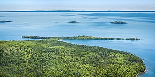
The Slate Islands are a small archipelago in Lake Superior, Ontario, Canada, about 12 kilometres (7.5 mi) south of the town of Terrace Bay. The island group, consisting of 15 islands in total, was created by a meteorite impact which formed a crater about 32 km (20 mi) wide. In 1985, the Ontario government established the Slate Islands as a natural environment provincial park. The islands are notable for having Ontario's largest herd of boreal woodland caribou.

Pukaskwa National Park is a national park located south of the town of Marathon, Ontario in the Thunder Bay District of northern Ontario, Canada. Established in 1978, Pukaskwa is known for its vistas of Lake Superior and boreal forests. The park covers an area of 1,878 square kilometres (725 sq mi), and protects part of the longest undeveloped shoreline anywhere on the Great Lakes.
Timberlea is a community located within the Municipality of Halifax in Nova Scotia, Canada.

Nova Scotia is a province located in Eastern Canada fronting the Atlantic Ocean. One of the Maritime Provinces, Nova Scotia's geography is complex, despite its relatively small size in comparison to other Canadian provinces.
Transportation in North America is performed through a varied transportation system, whose quality ranges from being on par with a high-quality European motorway to an unpaved gravelled back road that can extend hundreds of miles. There is also an extensive transcontinental freight rail network, but passenger railway ridership is lower than in Europe and Asia.

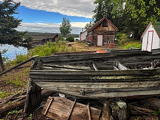
SS Kamloops was a Canadian lake freighter that was part of the fleet of Canada Steamship Lines from its launching in 1924 until it sank with all hands in Lake Superior off Isle Royale, Michigan, United States, on or about 7 December 1927.
Lake Superior National Marine Conservation Area is a National Marine Conservation Area (NMCA) on the north shore of Lake Superior in Ontario, and is a unit of the national park system. Established on September 1, 2015, it is the largest freshwater marine protected area in the world.

Michigan consists of two peninsulas surrounded primarily by four of the Great Lakes and a variety of nearby islands. The Upper Peninsula is bounded on the southwest by Wisconsin, and the Lower Peninsula is bounded on the south by Indiana and Ohio. Both land masses are also separated from the Canadian province of Ontario by waterways of the Great Lakes, and from each other by the Straits of Mackinac. Because its land is largely surrounded by the Great Lakes, which flow into the Saint Lawrence River, Michigan is the only U.S. state whose streams and rivers are almost entirely within the Great Lakes-St. Lawrence watershed.

Michipicoten Island is an island in Ontario, Canada, in the northeastern part of Lake Superior, about 175 kilometres (109 mi) northwest of Sault Ste. Marie and 65 kilometres (40 mi) southwest of Wawa, Ontario. At its closest point to mainland Ontario, the island is located about 16 kilometres (9.9 mi) from the mainland. It falls within the boundaries of Thunder Bay District. The third largest island in Lake Superior, after Isle Royale and St. Ignace Island, Michipicoten Island is 27 kilometres (17 mi) long and 10 kilometres (6.2 mi) wide at its widest point.

Ship Harbour is a rural community located along the Eastern Shore of Nova Scotia, Canada, in the Halifax Regional Municipality. It is situated at the head of a natural harbour of the same name which opens into the Atlantic Ocean. The community is located along Trunk 7, approximately 80 kilometres (50 mi) east of Halifax, Nova Scotia and 45 kilometres (28 mi) west of Sheet Harbour, Nova Scotia. The area was settled in 1783 by a group of Loyalists from the Royal Nova Scotia Volunteer Regiment. The mi'kmaq referred to the area as Tedumunaboogwek, meaning "water-worn rock". The name of the community was derived from the name of the harbour, which in turn was derived from a rock at the entrance to the harbour, named Ship Rock, as it resembles a vessel from a distance. Ship Harbour is home to the Ship Harbour Mussel Farm, one of the largest mussel farm in North America. It is also home to Ralph's Downeast Diner, a small diner on Highway 7. It was previously Family Fries. There is also a community hall that hosts meeting for the Lake Charlotte region. West Ship Harbour Road collides with Nova Scotia Trunk 7 in Ship Harbour, which connects Ship Harbour with Owls Head, Little Harbour, Clam Harbour, Clam Harbour Beach Provincial Park and Lake Charlotte. Some minor roads include: Head Ship Harbour Loop Road, River Road, Bruce Drive, Newcombes Lane, Eisan Point Road and Goose Lane.
Passage Island is a small island in the U.S. territory in western Lake Superior. It is the northeasternmost island in Isle Royale National Park, and the northernmost part of Michigan with any human-made structures, although the Gull Island chain is slightly further north. The island is uninhabited, but has a lighthouse and a short hiking trail. The U.S. National Park Service conducts tours of the island which depart from Rock Harbor on Isle Royale.

Caribou Island is an uninhabited island in the eastern end of Lake Superior, 40 kilometres (25 mi) south of Michipicoten Island. It lies entirely within the territorial waters of Canada although only about five kilometres from the international border between Canada and the United States. It is approximately 5.6 kilometres (3.5 mi) long and 2.4 kilometres (1.5 mi) wide, and 1,600 acres (647 ha) in area. The interior is low scrub and bog with small lakes, Little Italy, Hambone, and Deer Lake among many unnamed ones. Several of the lakes are maintained by beavers and all are several feet above Lake Superior.
Washington Island is an uninhabited island in Lake Superior. It is within the boundary of Keweenaw County and Isle Royale National Park, a national park located within the U.S. state of Michigan. It is the westernmost point marked on most maps of the elongated archipelago that makes up this park. However, a small islet called Bottle Island and an even smaller shoal that breaks the lake surface, Rock of Ages, are located further westward.

Algoma was a screw steamer built in 1883. She sank off Mott Island near Isle Royale in Lake Superior in 1885 and some of her remains are still on the lake bottom. The wreck was placed on the National Register of Historic Places in 1984.

The Cumberland was a wooden-hulled side paddlewheeler built in 1871; it was wrecked off the shore of Isle Royale in Lake Superior in 1877 and the remains are still on the lake bottom. The wreck was placed on the National Register of Historic Places in 1984.

SS Monarch was a passenger-package freighter built in 1890 that operated on the Great Lakes. She was sunk off the shore of Isle Royale in Lake Superior in 1906 and the remains of her wreck and cargo are still on the lake bottom. The wreck was placed on the National Register of Historic Places in 1984.
Caribou Island is an uninhabited island in Lake Superior, approximately 1.5 kilometres (0.93 mi) south of the township of Shuniah, Ontario and approximately 32 kilometres (20 mi) east of the city of Thunder Bay. It is approximately 3.3 kilometres (2.1 mi) long and 0.7 kilometres (0.43 mi) wide, and 371 acres (150 ha) in area. The north shore of the island features steep cliffs leading to an elevated plateau. Atop the plateau lies a small kettle lake.