Carmel in the Bible refers to two distinct places:

Wabash County is a county located in the U.S. state of Illinois. According to the 2010 census, it had a population of 11,947. Its county seat is Mount Carmel. It is located in the southern portion of Illinois known locally as "Little Egypt".

Carmel-by-the-Sea, often simply called Carmel, is a city in Monterey County, California, United States, founded in 1902 and incorporated on October 31, 1916. Situated on the Monterey Peninsula, Carmel is known for its natural scenery and rich artistic history. In 1906, the San Francisco Call devoted a full page to the "artists, writers and poets at Carmel-by-the-Sea", and in 1910 it reported that 60 percent of Carmel's houses were built by citizens who were "devoting their lives to work connected to the aesthetic arts." Early City Councils were dominated by artists, and several of the city's mayors have been poets or actors, including Herbert Heron, founder of the Forest Theater, bohemian writer and actor Perry Newberry, and actor-director Clint Eastwood.
Mount Carmel is a city in and the county seat of Wabash County, Illinois, United States. At the time of the 2010 census, the population was 7,284, while the next largest town in Wabash County is Allendale, population 475. Located at the confluence of the Wabash, Patoka, and White Rivers, Mount Carmel borders both Gibson and Knox counties of Indiana. A small community known informally as East Mount Carmel sits near the mouth of the Patoka River on the opposite side of the Wabash River from Mount Carmel. Mount Carmel is 5 miles (8.0 km) northeast of the Forest of the Wabash, a National Natural Landmark within Beall Woods State Park and about a mile north-northeast of one of its main employers, the Gibson Generating Station. Mount Carmel is also the home of Wabash Valley College, part of the Community College System of Eastern Illinois.

Carmel Valley Village is a census-designated place (CDP) in Monterey County, California, United States. At the time of the 2010 census the population was 4,407, down from 4,700 at the 2000 census. In November 2009, a majority of residents voted against incorporation.
Notre Dame, French for "Our Lady", a title of Mary, mother of Jesus, most commonly refers to:
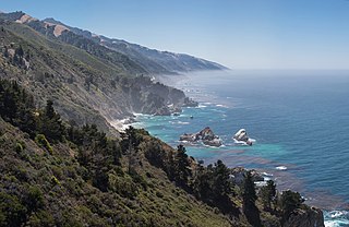
Big Sur ['bɪg ˈsɝ] is a rugged and mountainous section of the Central Coast of California between Carmel Highlands and San Simeon, where the Santa Lucia Mountains rise abruptly from the Pacific Ocean. It is frequently praised for its dramatic scenery. Big Sur has been called the "longest and most scenic stretch of undeveloped coastline in the contiguous United States", a sublime "national treasure that demands extraordinary procedures to protect it from development", and "one of the most beautiful coastlines anywhere in the world, an isolated stretch of road, mythic in reputation". The views, redwood forests, hiking, beaches, and other recreational opportunities have made Big Sur a popular destination for about 7 million people who live within a day's drive and visitors from across the world. It is among the top 35 tourist destinations world-wide. The region receives about the same number of visitors as Yosemite National Park, but offers only limited bus service, few restrooms, and a narrow two-lane highway that for most of its length clings to the steep coastal cliffs. North-bound traffic during the peak summer season and holiday weekends is often backed up for about 20 miles (32 km) from Big Sur Village to Carmel. Due to the large number of visitors, congestion and slow traffic between Carmel and Posts is becoming the norm.
Alta or ALTA may refer to:
Point Lobos Ranch is an 1,315 acres (532 ha) parcel of land in the northern region of Big Sur, California, United States. San Jose Creek on the ranch was the site of an Ohlone village for thousands of years. Europeans first visited the site when the Portola Expedition camped on the site for 10 days in the winter of 1769. It is currently owned by the California State Park System which since acquiring the land in 2001 has stated that the land is being held for possible use as a state park.

Point Lobos and the Point Lobos State Natural Reserve is the "crown jewel" of California's 280 state parks. Australian-born landscape artist Francis McComas described the point as the "greatest meeting of land and water in the world." Adjoining Point Lobos is "one of the richest marine habitats in California." The ocean habitat is protected by two marine protected areas, the Point Lobos State Marine Reserve and Point Lobos State Marine Conservation Area. The sea near Point Lobos is considered one of the best locations for scuba diving on the Monterey Peninsula and along the California coast.
Hatton Canyon is a canyon in Carmel Valley, California, United States, preserved for urban open space as a state park property. The canyon harbors Monterey pines and 10 acres (4.0 ha) of wetland. For decades it was under consideration as a possible site for a 2.8-mile-long (4.5 km) freeway to relieve traffic on a parallel stretch of Highway 1. However homeowners and environmentalists opposed the plan since its proposal in 1952, ultimately gaining major political support in the 1990s. In 2002 Governor Gray Davis signed legislation that officially transferred the property from CalTrans to California State Parks. It is currently accessible to the public at Carmel Valley Road via a dirt trail at the mouth of Carmel Valley. Plans to pave the trail to allow bicycle access were set aside in 2009 due to concerns of some neighbors.
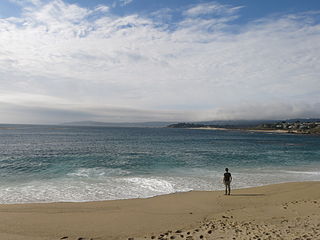
Carmel River State Beach is a state park unit in Carmel, California, United States, featuring a 1-mile-long (1.6 km) protected beach with a lagoon formed by the Carmel River. The lagoon attracts many migratory birds. The state beach includes Monastery Beach, which is popular with scuba divers. Sea kayakers also frequent the beach, which has easy access to the natural reserves of Point Lobos. The 297-acre (120 ha) park was established in 1953.

The Carmel River is a 41 mi (66 km) river on the Central Coast of California in Monterey County that originates in the Ventana Wilderness of the Santa Lucia Mountains. The river flows northwest through the Carmel Valley with its mouth at the Pacific Ocean south of Carmel-by-the-Sea, at Carmel Bay. The Carmel River is considered the northern boundary of Big Sur, the other boundaries being San Carpóforo Creek and the Pacific coastline.
A mystic is a person who practices mysticism, or a reference to a mystery, mystic craft, first hand-experience or the occult.

Garrapata State Park is a state park of California, United States, located on California State Route 1 6.7 miles (10.8 km) south of Carmel and 18 miles (29 km) north of Big Sur Village on the Monterey coast. The 2,939-acre (1,189 ha) park was established in 1979. California sea lions, harbor seals and sea otters frequent the coastal waters while gray whales pass close by during their yearly migration.
Saint John River may refer to:
The River Pocwock is a tributary of the Saint John River, flowing in:
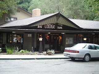
Big Sur is an unincorporated community village in Big Sur, Monterey County, California. It is located along a 1 mile (1.6 km) long stretch of Big Sur Coast Highway in the Big Sur Valley 24 miles (39 km) south of Carmel, California. The village contains the largest collection of shops and visitor services along the entire 71-mile (114 km) segment of California State Route 1 between Malpaso Creek near Carmel Highlands in the north and San Carpóforo Creek near San Simeon in the south. The population is about 1,463. The collection of small roadside businesses and homes is often confused with the larger region, also known as Big Sur. On March 6, 1915, United States Post Office granted the English-speaking resident's request to change the name of their post office from Arbolado to Big Sur. Caltrans also refers to the village as Big Sur.