
Creggan is a townland in County Tyrone, Northern Ireland. It is situated in the historic barony of Omagh East and the civil parish of Termonmaguirk and covers an area of 4022 acres.

Artigarvan is a village and townland in County Tyrone, Northern Ireland. It is 3 miles from Strabane and 4 miles from Dunnamanagh, within the Strabane District Council area. It is called Airtigarvan in Ulster-Scots.

Ballymagorry or Ballymagory is a small village and townland in County Tyrone, Northern Ireland. It is west of Artigarvan and 5 kilometres (3.1 mi) north of Strabane. In the 2001 Census it had a population of 565. It lies within the Strabane District Council area and lies on the River Glenmornan.

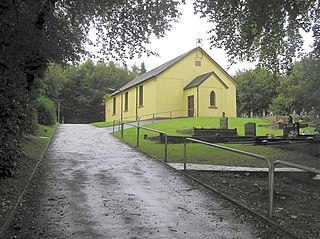
Altamuskin or Altamooskan is a small village and townland in County Tyrone, Northern Ireland. It is situated in the historic barony of Clogher and the civil parish of Errigal Keerogue and covers an area of 1165 acres. In the 2014 Census Altamuskin had a population of 127 people. It lies within the Fermanagh and Omagh District Council area and is home to St Bridget's Altamuskin. The population of the townland declined during the 19th century:

Dooish is a village and townland near Drumquin in County Tyrone, Northern Ireland. The townland is situated in the historic barony of Omagh West and the civil parish of Longfield West and covers an area of 845 acres. In the 2001 Census it had a population of 93 people. It lies within the Omagh District Council area.

Drumnakilly .) is a small village and townland between Carrickmore and Omagh in County Tyrone, Northern Ireland. In the 2001 Census it had a population of 114 people. The townland is situated in the historic barony of Strabane Upper and the civil parish of Termonmaguirk and covers an area of 1,352 acres. It lies within the Omagh District Council area.
Altmore ) is a hamlet and townland in County Tyrone, Northern Ireland. It is five miles from Carrickmore and four miles from Pomeroy. The townland is actually called Altmore and is situated in the historic barony of Dungannon Middle and the civil parish of Pomeroy and covers an area of 1117 acres.

Brackaville or Bracaville is a village and townland near Coalisland in County Tyrone, Northern Ireland. It is situated in the historic barony of Dungannon Middle and the civil parish of Donaghenry and covers an area of 235 acres on the western side of Lough Neagh.
Ballygittle is a townland in County Tyrone, Northern Ireland. It is situated in the historic barony of Dungannon Middle and the civil parish of Clonoe and covers an area of 169 acres. It is close to Stewartstown.

Evish is a small rural community area and townland in County Tyrone, Northern Ireland, 3 miles from Strabane and 7 miles from Plumbridge. It is situated in the barony of Strabane Lower and the civil parish of Camus and covers an area of 870 acres.

Carnteel ) is a hamlet, townland and civil parish, about 2 miles northeast of Aughnacloy in County Tyrone, Northern Ireland. It is situated in the historic barony of Dungannon Lower.

Derrytresk is a townland outside Coalisland, County Tyrone, Northern Ireland and is close to the shores of Lough Neagh. It is situated in the historic barony of Dungannon Middle and the civil parish of Clonoe and covers an area of 1020 acres. Derrytresk consists of sub-townlands: Derryvarne, Derrykiltena and Derrynahaskila.
Ballymully Glebe is a townland in County Tyrone, Northern Ireland. It is situated in the historic barony of Dungannon Upper and the civil parish of Desertcreat and covers an area of 144 acres.
Altishane or Altishahane is a small settlement and townland in County Tyrone, Northern Ireland. It lies near Strabane, between Plumbridge and Donemana. It is situated in the historic barony of Strabane Lower and the civil parish of Donaghedy and covers an area of 744 acres. There is one primary school, Altishane Primary School.

Aghalunny is a townland in County Tyrone, Northern Ireland. It is situated in the historic barony of Omagh West and the civil parish of Termonamongan and covers an area of 493 acres.
Gortalowry is a townland in County Tyrone, Northern Ireland. It is situated in the barony of Dungannon Upper and the civil parish of Derryloran and covers an area of 281 acres. The townland is partly rural, but includes the southern part of the town of Cookstown.
Lisgobban is a townland in County Tyrone, Northern Ireland. It is situated in the barony of Dungannon Middle and the civil parish of Clonfeacle and covers an area of 135 acres.
Derrycrin (Conyngham) is a townland in County Tyrone, Northern Ireland. It is situated in the historic barony of Dungannon Upper and the civil parish of Ballinderry and covers an area of 515 acres.
Derrycrin (Eglish) is a townland in County Tyrone, Northern Ireland. It is situated in the historic barony of Dungannon Upper and the civil parish of Ballinderry and covers an area of 444 acres.
Derryloughan is a townland in County Tyrone, Northern Ireland. It lies on the southwest corner of Lough Neagh, 4 miles from Coalisland. It is situated in the historic barony of Dungannon Middle and the civil parish of Clonoe and covers an area of 1751 acres.
