
Arcot is a town in Ranipet district in the state of Tamil Nadu, India. Located on the southern banks of Palar River, the city straddles a trade route between Chennai and Bangalore or Salem, between the Mysore Ghat and the Javadi Hills.

The Carnatic region is the peninsular South Indian region between the Eastern Ghats and the Bay of Bengal, in the erstwhile Madras Presidency and in the modern Indian states of Tamil Nadu and southern coastal Andhra Pradesh. During the British era, demarcation was different and the region included current-day Karnataka and the whole region south of the Deccan.

The Carnatic wars were a series of military conflicts in the middle of the 18th century in India's coastal Carnatic region, a dependency of Hyderabad State, India. The first Carnatic wars were fought between 1740 and 1748.
Arunthathiyar is a scheduled caste community mostly found in the Indian state of Tamil Nadu. The term has two distinct usages: for the purposes of the state government's positive discrimination program, in 2009 it was designated an umbrella term for the Arunthatiyar, Chakkiliyar (Sakkiliyar), Madari, Madiga, Pagadai, Thoti and Adi Andhra communities with a total population of 2,150,285, accounting for 14.89% of the Scheduled Caste population according to the 2011 Census of India. While the Office of the Registrar-General, which administers the census of India, does not recognize all of those communities as one.

Muhammad Yusuf Khan was a commandant of the British East India Company's Madras Army. He was born in a Tamil Vellalar family in a village called Keelapanaiyur in British India, what is now in Mudukulathur Taluk, Ramanathapuram District of Tamil Nadu, India. He converted to Islam and was named Muhammad Yusuf Khan. He was popularly known as Khan Sahib when he became the ruler of Madurai. He became a warrior in the Arcot troops, and later a commandant for the British East India Company troops. The British and the Arcot Nawab employed him to suppress the Puli Thevar uprising in South India. Later he was entrusted to administer the Madurai country when the Madurai Nayak rule ended.

Ariyalur is a town and district headquarters of Ariyalur district in the South Indian state of Tamil Nadu and is rich in limestone, surrounded with seven cement factories and two sugar factories. The town is located at a distance of 310 km (190 mi) from the state capital Chennai.

The Carnatic Sultanate was a kingdom in South India between about 1690 and 1855, and was under the legal purview of the Nizam of Hyderabad, until their demise. They initially had their capital at Arcot in the present-day Indian state of Tamil Nadu. Their rule is an important period in the history of the Carnatic and Coromandel Coast regions, in which the Mughal Empire gave way to the rising influence of the Maratha Empire, and later the emergence of the British Raj.

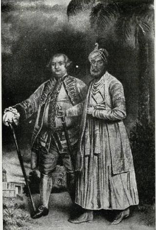
Muhammad Ali Khan Wallajah, or Muhammed Ali, Wallajah, was the Nawab of the Carnatic from 1749 until his death in 1795. He declared himself Nawab in 1749. This position was disputed between Wallajah and Chanda Sahib. In 1752, after several clashes, Chanda Sahib's forces and his French allies were expelled from Arcot, officially declaring Wallajah as Nawab on 26 August 1765. His reign was recognised by Mughal emperor Shah Alam II.
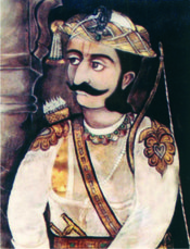
Ali Dost Khan, often referred to as Dost Ali Khan, was the Nawab of the Carnatic from 1732 to 1740. He was the son of Ghulam Ali Khan, brother of the Nawab Saadatullah Khan. His childless uncle adopted him as heir, and he succeeded his uncle in 1732, he successfully gained the investiture and an official Firman by the Mughal Emperor Muhammad Shah.
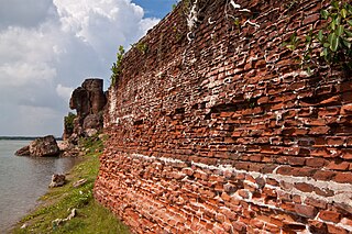
The ruins of Alamparai Fort lie near Kadappakkam in India, a village 50 km from Mamallapuram on the land overlooking the sea. Constructed in the late 17th century during the Mughal era, the Alamparai Fort once had a 100-metre long dockyard stretching into the sea, from which zari cloth, salt, and ghee were exported. During 1735 AD it was ruled by Nawab Doste Ali Khan. In 1750, for the services rendered by the famous French commander Dupleix to Subedar Muzaphar Jung, the fort was given to the French. When French were defeated by the British, the fort was captured and demolished in 1760 AD. More recently the structure was damaged in the 2004 Indian Ocean earthquake.

Palaiyakkarars, or Polygar, Poligar or Palegara in Andhra, Karnataka and Tamil Nadu were the holders of a small kingdom as a feudatory to a greater sovereign. Under this system, palayam was given for valuable military services rendered by any individual. The word pālayam means domain, a military camp, or a small kingdom. This type of Palayakkarars system was in practice during the rule of Pratapa Rudhra of Warangal in the Kakatiya kingdom. The system was put in place in Tamil Nadu by Viswanatha Nayak, when he became the Nayak ruler of Madurai in 1529, with the support of his minister Ariyanathar. Traditionally there were supposed to be 72 Palayakkarars. The majority of those Palaiyakkarar, who during the late 17th- and 18th-centuries controlled much of the Kannada and Telugu regions as well as the Tamil area, had themselves come from the Boya, also known as Bedar Nayakars in Kannada and Telugu regions, and Kallar, Maravar and Vatuka communities in Tamil region. Most palayakkars in western Tirunelveli and in Ramanathapuram were Maravar, those of Madurai, Tiruchi and Thanjavur Kallar, and those of eastern Tirunelveli, Dindigal and Coimbatore Nayak.
Raghuji I was a Maratha general of the Bhonsle clan who established the Nagpur Kingdom in much of east-central India during the reign of Chhatrapati Shahu I. His successors ruled the kingdom until 1853.

Ghulam Husain Ali Khan aka Ghulam Hussainy or Umdat ul-Umra, was the Nawab of the Carnatic state in the Mughal Empire from 1795 to 1801.
Madras Presidency was an administrative subdivision (presidency) of British India. At its greatest extent, Madras Presidency included much of southern India, including the present-day Indian State of Tamil Nadu, the Malabar region of North Kerala, Lakshadweep Islands, the Coastal Andhra and Rayalaseema regions of Andhra Pradesh, Undivided Koraput and Ganjam districts of Orissa and the Bellary, Dakshina Kannada, and Udupi districts of Karnataka. The presidency had its capital at Madras.

Pudukkottai is a village in the Ariyalur taluk of Ariyalur district, Tamil Nadu, India. The village has a population of 1856 in 2001 making it smallest settlement in Ariyalur. The Village is close to the Tiruchirapplli District and Thanjavur District border and is within a short distance of locations such as Tiruchirappalli, the Ariyalur and Thanjavur.

The Madras Presidency was a province of British India comprising most of the present day Tamil Nadu and Andhra Pradesh along with a few districts and taluks of Karnataka, Kerala and Odisha. A few princely states, notably Ramnad and Pudukkottai also merged into the Presidency at some or the other time. The Presidency lasted till 1950, when it became the Madras State after India became a republic. In 1953, Telugu-speaking regions of the state split to form Andhra State. Subsequently, in 1956, Kannada- and Malayalam-speaking areas were merged with Mysore and Travancore-Cochin respectively.

The siege of Trichinopoly was part of an extended series of conflicts between the Nizam of Hyderabad and the Maratha Empire for control of the Carnatic region. On 29 August 1743, after a six-month siege, Murari Rao surrendered, giving Nizam ul Mulk (Nizam) the suzerainty of Trichinopoly. By the end of 1743, the Nizam had regained full control of Deccan. This stopped the Maratha interference in the region and ended their hegemony over the Carnatic. The Nizam resolved the internal conflicts among the regional hereditary nobles (Nawabs) for the seat of governor (Subedar) of Arcot State, and monitored the activities of the British East India company and French East India Company by limiting their access to ports and trading.

South Arcot District was a district in the Madras Presidency of British India. It covered the area of the present-day districts of Cuddalore, Kallakurichi and Viluppuram in the Indian state of Tamil Nadu. The district was divided into eight taluks and covered a total area of 13,510 square kilometres (5,217 sq mi). The administrative headquarters was the town of Cuddalore.
The Indian independence movement had a long history in the Tamil-speaking districts of the then Madras Presidency going back to the 18th century.

The Kingdom of Awadh was a Mughal subah, then an independent kingdom, and lastly a princely state in the Awadh region of North India until its annexation by the British in 1856. The name Oudh, now obsolete, was once the anglicized name of the state, also written historically as Oudhe.


