Neville Langrell "Bill" Barlee was a Canadian politician who was first elected to the Legislative Assembly of British Columbia as a New Democrat in 1988. He served as Minister of Agriculture, Fisheries and Food from 1991 until 1993 and then as Minister of Small Business, Tourism and Culture from 1993 until 1996.

New Denver is a village in the Central Kootenay region of British Columbia, Canada at the mouth of Carpenter Creek, on the east shore of Slocan Lake, in the West Kootenay region of southeastern British Columbia. The village is 47 kilometres (29 mi) west of Kaslo on Highway 31A, and 47 kilometres (29 mi) southeast of Nakusp and 32 kilometres (20 mi) northeast of Slocan on Highway 6.

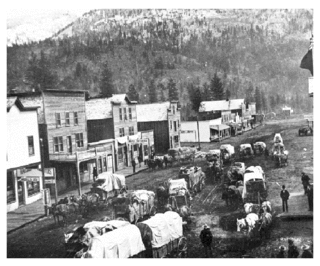
Sandon is in the foothills of the Selkirk Mountains in the West Kootenay region of southeastern British Columbia. The near ghost town lies off BC Highway 31A, and is at the confluence of Sandon Creek into Carpenter Creek. By road, the place is about 14 kilometres (9 mi) east of New Denver and 43 kilometres (27 mi) west of Kaslo.

Greenwood is a city in south central British Columbia. It was incorporated in 1897 and was formerly one of the principal cities of the Boundary Country smelting and mining district. It was incorporated as a city originally and has retained that title despite the population decline following the closure of the area's industries.
Cascade City or Cascade was a Canadian Pacific Railway construction era boom town in the Boundary Country of the West Kootenay region of British Columbia, Canada. Because of its location near the Canada–United States border, it was also called the "Gateway to the Boundary Country".
Cody is at the confluence of Cody Creek into Carpenter Creek in the West Kootenay region of southeastern British Columbia. The ghost town, about one kilometre east of Sandon, lies off BC Highway 31A. By road, the former mining community is about 15 kilometres (9 mi) east of New Denver and 44 kilometres (27 mi) west of Kaslo.
Burton is a settlement on the east shore of Lower Arrow Lake in the West Kootenay region of southeastern British Columbia.

Fairview is a ghost town in British Columbia on the west side of the Okanagan River between Cawston and Oliver. It is the original townsite for what is now the town of Oliver, famous for the Fairview Hotel that burned down in 1902.
Granite Creek is a creek and townsite in British Columbia located in the Similkameen region. Granite Creek flows north into the Tulameen River and joins that river approximately one and a half miles to the east of Coalmont, British Columbia. It is assumed Granite Creek yielded more than $500,000 in placer gold since its discovery. Gold nuggets worth $50 in value were not unusual in the early years. The creek was mined by Europeans and Chinese. Granite Creek was hydraulicked near its mouth in the 1890s.
Britton Creek is a tributary of the Tulameen River in British Columbia. This creek is 8 miles (13 km) southwest of the old town of Tulameen. Britton Creek is located in a region of British Columbia called the Similkameen. The creek can be reached by road. Britton Creek was originally known as Eagle Creek. It was discovered in 1885 when gold was recovered from the creek. The gold was mainly close to the mouth of the creek. The creek also yielded placer platinum. The last great find was by Garnet Sootheran in 1926. Garnet discovered platinum and gold placer. According to historian Bill Barlee there may still be gold in the creek
Lawless Creek is a creek in the Similkameen region of British Columbia. Lawless Creek flows south-east into the Tulameen River about 4 miles (6.4 km) west of the old village of Tulameen, British Columbia. Lawless Creek was originally called Bear Creek. The creek was discovered in 1885 and mined for gold. Platinum was also found there
Whipsaw Creek is a creek in the Similkameen region of British Columbia. The creek flows into the Similkameen River from the west and is approximately 6 miles (9.7 km) upriver from Princeton, British Columbia. The Crowsnest Highway, Highway 3, makes a dangerous hair pin bend around the creek banks to avoid the defile. Whipsaw Creek has been mined for gold.
Boundary Creek is a tributary of the Kettle River in the Boundary Country region of south central British Columbia. The creek is approximately 32 kilometres (20 mi) in length, flowing from the northeast, passing east of Midway, and only the final one-quarter mile (0.40 km) is in northeastern Washington, US.
Jolly Creek is a creek located in the Boundary Country region of British Columbia. The creek is south of Conkle Lake. Jolly Creek flows into Rock Creek. It was discovered in 1860 and has been mined for gold. The Creek was named after local prospector Jolly Jack Thornton.
May Creek is a creek located in the Boundary Country of British Columbia. The creek is a tributary of July Creek. May Creek flows into July Creek about five miles west of Grand Forks, British Columbia. The creek has been mined for gold.

Erie Creek is a creek located in the West Kootenay region of British Columbia. The creek flows into the Salmo River. It was discovered in the 1860s. Erie Creek was originally called North Fork Creek. The creek was mined for gold.

Quartz Creek is a creek in Selkirk Mountains in the West Kootenay region of the Regional District of Central Kootenay in British Columbia, Canada. This short creek flows into the Salmo River in Ymir, British Columbia. The source of the creek is just to the west of the Ymir townsite a few kilometres up Round Mountain. Quartz creek was mined for gold in the 1860s. The creek is the source of drinking water in the town of Ymir. The Regional District of Central Kootenay added a filtration system in the early 2010s for the community.
Rover Creek is a creek in the West Kootenay Region of British Columbia. The creek is located west of Forty Nine Creek and flows into the Kootenay River. The creek has been mined for gold.
Skeff Creek is a creek in the Boundary Country region of British Columbia. The creek flows east into July Creek, west of Smelter Lake, Similkameen Division Yale Land District. Skeff Creek used to be called Taylor Creek. The creek has been mined.
Gold Trails and Ghost Towns is a Canadian historical documentary show, created and produced by television station CHBC-TV in Kelowna, British Columbia for Canadian syndication and hosted by Mike Roberts with historian/storyteller Bill Barlee. The show was filmed in a studio which resembled an old trapper's cabin. Mike and Bill discussed prospectors and the history of British Columbia around 1900.
