Related Research Articles
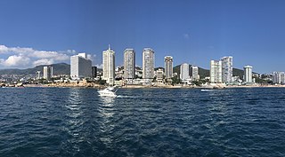
Acapulco de Juárez, commonly called Acapulco, is a city and major seaport in the state of Guerrero on the Pacific Coast of Mexico, 380 kilometres (240 mi) south of Mexico City. Acapulco is located on a deep, semicircular bay and has been a port since the early colonial period of Mexico's history. It is a port of call for shipping and cruise lines running between Panama and San Francisco, California, United States. The city of Acapulco is the largest in the state, far larger than the state capital Chilpancingo. Acapulco is also Mexico's largest beach and balneario resort city. Acapulco de Juárez is the municipal seat of the municipality of Acapulco.

Guerrero, officially the Free and Sovereign State of Guerrero, is one of the 32 states that comprise the 32 Federal Entities of Mexico in Mexico. It is divided into 81 municipalities. The state has a population of about 3.5 million people. It is located in southwest Mexico and is bordered by the states of Michoacán to the north and west, the State of Mexico and Morelos to the north, Puebla to the northeast and Oaxaca to the east. In addition to the capital city, Chilpancingo and the largest city Acapulco, other cities in Guerrero include Petatlán, Ciudad Altamirano, Taxco, Iguala, Ixtapa, and Zihuatanejo. Today, it is home to a number of indigenous communities, including the Nahuas, Mixtecs, Tlapanecs, Amuzgos, and formerly Cuitlatecs. It is also home to communities of Afro-Mexicans in the Costa Chica region.

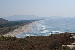
Puerto Escondido is a small port and tourist center in the municipality of San Pedro Mixtepec Distrito 22 in the Mexican state of Oaxaca. Prior to the 1930s, there was no town. The bay had been used as a port intermittently to ship coffee, but there was no permanent settlement due to the lack of potable water. The name "Puerto Escondido" had roots in the legend of a woman who escaped her captors and hid here. The Nahuatl word for this area was Zicatela, meaning “place of large thorns". Today, it refers to the area's most famous beach.

Iguala, known officially as Iguala de la Independencia, is a historic city located 102 km (63 mi) from the state capital of Chilpancingo, in the Mexican state of Guerrero in southwestern Mexico.

San Marcos is a town in the Mexican state of Guerrero. It serves as the municipal seat of the surrounding municipality of San Marcos.
Costa Grande of Guerrero is a sociopolitical region located in the Mexican state of Guerrero, along the Pacific Coast. It makes up 325 km (202 mi) of Guerrero's approximately 500 km (311 mi) coastline, extending from the Michoacán border to the Acapulco area, wedged between the Sierra Madre del Sur and the Pacific Ocean. Acapulco is often considered part of the Costa Grande; however, the government of the state classifies the area around the city as a separate region. The Costa Grande roughly correlates to the Cihuatlán province of the Aztec Empire, which was conquered between 1497 and 1504. Before then, much of the area belonged to a dominion under the control of the Cuitlatecs, but efforts by both the Purépecha Empire and Aztec Empire to expand into this area in the 15th century brought this to an end. Before the colonial period, the area had always been sparsely populated with widely dispersed settlements. The arrival of the Aztecs caused many to flee and the later arrival of the Spanish had the same effect. For this reason, there are few archeological remains; however, recent work especially at La Soledad de Maciel has indicated that the cultures here are more important than previously thought. Today, the area economically is heavily dependent on agriculture, livestock, fishing and forestry, with only Zihuatanejo and Ixtapa with significantly developed infrastructure for tourism. The rest of the coast has been developed spottily, despite some government efforts to promote the area.
Radio y Televisión de Guerrero is a statewide public television network and series of radio stations, owned and operated by the agency of the same name in the State of Guerrero.
Federal Highway 95 connects Mexico City to Acapulco, Guerrero. The Autopista del Sol is a tolled alternative, which bypasses several towns of the state of Guerrero, including the city Iguala, and thus reduces transit time between Acapulco from Mexico city from 8 hours to almost 3.5 hours.

Acapulco de Juárez is one of the 81 municipalities of Guerrero, in southwestern Mexico, along Acapulco Bay on the Pacific coast. The municipal seat lies at Acapulco.

Atoyac de Álvarez is one of the 81 municipalities of Guerrero, in southern Mexico. The municipal seat lies at Atoyac de Álvarez. The municipality covers an area of 1,638.4 km2 (632.6 sq mi).
Zumpango del Río is the capital of Eduardo Neri Municipality, within the state of Guerrero, in central−western Mexico.
The 2011 Zumpango earthquake occurred at 19:47 local time on 10 December with a moment magnitude of 6.5 and a maximum Mercalli intensity of VII. Its epicenter was located in the city Zumpango, Guerrero, roughly equidistant between the metropolitan areas of Mexico City and Acapulco. The quake was felt in Guerrero, Michoacán, Mexico State, Mexico City and Puebla.

The Triangle of the Sun is a tourist area in the state of Guerrero that runs through the Sierra Madre del Sur of that state. This tourist area is formed by the cities of Acapulco in the south, the pair of Ixtapa-Zihuatanejo in the north, and Taxco in the center of the state. These cities are those that receive more tourists in Guerrero.

Manuel Añorve Baños is a Mexican politician affiliated with the Institutional Revolutionary Party (PRI). He serves as a senator of the LXIV Legislature of the Mexican Congress, representing the state of Guerrero. He also is a two-time federal deputy and two-time former mayor of Acapulco.
Same-sex marriage has been legal in Guerrero since 31 December 2022. After the Supreme Court of Justice of the Nation ruled that same-sex marriage bans are unconstitutional nationwide under the Constitution of Mexico on 12 June 2015, officials in Guerrero began announcing plans for a collective group wedding. Governor Rogelio Ortega Martínez submitted a same-sex marriage bill to Congress on 7 July 2015 and instructed civil registrars to issue marriage licenses to same-sex couples. Legislators lamented they would have preferred to have the bill passed before marriages took place, but given the time line presented, it was unlikely. On 10 July 2015, twenty same-sex couples were married by Ortega Martínez in Acapulco.
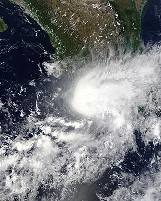
Hurricane Marty was a tropical cyclone that produced heavy rains and flooding in several states in Southwestern and Western Mexico. The twentieth named storm and twelfth hurricane of the annual hurricane season, Marty developed from a tropical wave on September 26, 2015, to the southwest of Acapulco, Guerrero, in Mexico. Initially a tropical depression, the system strengthened into a tropical storm early on the following day. Due to favorable atmospheric conditions, Marty continued to intensify, but wind shear sharply increased as the storm approached a large mid- to upper-level trough. Despite this, the cyclone deepened further, becoming a hurricane on September 28 and peaking with sustained winds of 80 mph (130 km/h) shortly thereafter. Wind shear quickly took its toll on the hurricane, weakening it to a tropical storm early on September 29. About 24 hours later, Marty degenerated into a post-tropical low-pressure area offshore Guerrero. The low further degenerated into a trough later on September 30, and eventually dissipated on October 4.
Federal Highway 95D is a toll highway connecting Mexico City to Acapulco, Guerrero. Highway 95D is among the most important toll roads in the country, serving as a backbone for traffic out of Mexico City toward Morelos and tourist destinations in Guerrero.

Guerreros de Acapulco were a Mexican football club that played in the Segunda División Profesional. The club was based in Acapulco de Juarez, Guerrero.
A moment magnitude Mw 7.0 or 7.1 earthquake occurred near the city of Acapulco in the Mexican state of Guerrero at 20:47 local time on 7 September with an estimated intensity of VIII (Severe) on the MMI scale. The earthquake killed 13 people and injured at least 23 others. At least 1.6 million people in Mexico were affected by the earthquake which resulted in localized severe damage. The earthquake occurred on the anniversary of the 2017 Chiapas earthquake which measured Mw 8.2. It was also the largest earthquake in Mexico since the 2020 Oaxaca earthquake.
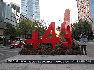
An antimonumento was installed in front of the Superior Court of Justice of Mexico City, on the median strip of Paseo de la Reforma Avenue, in the Cuauhtémoc borough of Mexico City. The work included the installation of a red number 43 made of metal along with a plus symbol, in reference to the forty-three students kidnapped—and possibly killed—in Iguala, Guerrero, in 2014 after being arrested for allegedly committing criminal offenses, plus the six students and witnesses killed during that event, and to honor the more than 150,000 people killed since the start of the Mexican drug war and the 30,000 disappeared persons reported by 2015. The anti-monument was installed by peaceful protesters during a demonstration on 26 April 2015 as a plea for justice and to prevent the case from being forgotten by the authorities and society. The sculpture became the first of its kind in Mexico and would inspire the installation of other guerrilla-like memorials throughout the city and in other states of the country.
References
- ↑ "Buscan cuerpos de desaparecidos en Carrizalillo, Guerrero". Excélsior. 3 November 2015.