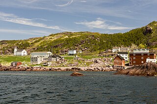
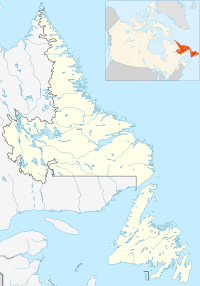
Piccadilly Slant-Abraham's Cove is a local service district and designated place in the Canadian province of Newfoundland and Labrador. It is located on the island of Newfoundland, along St. George's Bay, on the Port au Port Peninsula. The DPL consists of the fishing villages of Abraham's Cove and Piccadilly.
St. George's Bay - informally referred to as Bay St. George due to its French translation Baie St-George - is a large bay in the province of Newfoundland and Labrador, Canada. It is located on the west coast of the island of Newfoundland and comprises a sub-basin of the Gulf of St. Lawrence. The estimated population of the entire bay is 16,000, based on the demographic data of each community.

Open Hall-Red Cliffe is a local service district and designated place in the Canadian province of Newfoundland and Labrador.
Steady Brook is a Canadian town in the province of Newfoundland and Labrador. Located on the west coast of the island of Newfoundland, the town is situated 8 kilometres east of the city of Corner Brook in the lower Humber Valley. The town is surrounded by the Long Range Mountains and sits astride the Humber River. Steady Brook has become a thriving community in recent years as a result of provincial investments in the Marble Mountain alpine ski resort, along with golf courses and other recreational amenities.

Stephenville Crossing is a town in the Canadian province of Newfoundland and Labrador. It is on the island of Newfoundland at the easternmost limit of Bay St. George.
Gallants is located northeast of Stephenville, Newfoundland and Labrador, Canada. It was created as a Local Government Community on August 16, 1966.

Robinsons is a village in the Bay St. George area of the Canadian province of Newfoundland and Labrador. "Robinson's Head" has been on maps since about 1798. The headland and community were named after John Robinson from Ireland who lived in a cave in Robinson's Head. "Robinson's Station" about two miles from the original village came into being after the railway was constructed in the late 1890s and people, mainly those working at railway maintenance, settled in the area where the local road intersected the railway. The name "Robinson's Station" became simply "Robinson's" on October 1, 1960. Robinson's had a population of 299 in 1956. "Modern" Robinsons consists of the original Robinson's Head settlement (Robinsons), Robinsons Station, and Robinsons Junction. For census purposes, all three are counted under the "Robinsons" name. The community is located along Route 404.
Barachois Brook is a local service district and designated place in the Canadian province of Newfoundland and Labrador. It is on the western coast of the province, on Bay St. George, located just 5 km south of Stephenville Crossing.
Keels is a small town in the Canadian province of Newfoundland and Labrador, located about 3 kilometres from Duntara. The population of this municipality in the 2016 Canadian National Census was 51. This is down from 61 in 2011 and 73 in 2006. The earlier population figures show it had 85 in 2001, 101 in 1996, 128 in 1991, 115 in 1986, 206 in 1956 and 372 in 1940.
The Bonavista Peninsula is a large peninsula on the east coast of the island of Newfoundland in the Canadian province of Newfoundland and Labrador. It consists of 50 incorporated towns/unincorporated communities which have a population of 12,176 as of the 2016 Canadian Census. Bonavista is the largest population centre on the peninsula.
Port au Port East is a town in the Canadian province of Newfoundland and Labrador, situated on the shore of Isthmus Bay. The town had a population of 413 in the Canada 2021 Census. The town consists of the unincorporated communities of Port au Port and Romaines.
Fox Island River-Point au Mal is a local service district and designated place in the Canadian province of Newfoundland and Labrador. It is northwest of Stephenville.

College of the North Atlantic is one of the largest post-secondary educational and skills training centres in Atlantic Canada, with a history dating back 50 years. The college has 17 campus locations throughout the province of Newfoundland and Labrador in Canada, various partner universities in China and formerly operated a technical education college for the State of Qatar in the Middle East. The enabling legislation is the College Act.
Jeffrey's is a village located south west of Stephenville on the west coast of the island of Newfoundland, Canada. It had a population of 1,174 in 2016.

Black Duck Brook and Winterhouse is a local service district and designated place in the Canadian province of Newfoundland and Labrador. It consists of the unincorporated fishing settlements of Black Duck Brook and Winterhouse on the Port au Port Peninsula. The communities had a combined population of 57 in the Canada 2006 Census.
St. Teresa is a local service district and designated place in the Canadian province of Newfoundland and Labrador.
Black Duck is a local service district and designated place in the Canadian province of Newfoundland and Labrador that is 15 km (9 mi) east of the town of Stephenville. It is characterized by Harry's River, which runs past the community and is an Atlantic salmon fishing river.
Bay St. George South is a local service district and designated place in the Canadian province of Newfoundland and Labrador on the south coast of Bay St. George, a large bay on the west coast of the island of Newfoundland. Bay St. George South consists nine communities, namely Heatherton, Robinsons, Cartyville, McKay's, Jeffrey's, St. David's, St. Fintan's, Lock Leven en Highlands.
Michael H. Carty was an Irish-born lawyer and politician in Newfoundland. He served in the Newfoundland House of Assembly from 1882 to 1893 and from 1893 to 1900.

Division No. 1, Subdivision G is an unorganized subdivision on the Avalon Peninsula in Newfoundland and Labrador, Canada. It is in Division 1 and contains the unincorporated communities of Baccalieu Island, Besom Cove, Bradley's Cove, Burnt Point, Caplin Cove, Daniel's Cove, Grates Cove, Gull Island, Job's Cove, Kingston, Long Beach, Lower Island Cove, Low Point, Northern Bay, Ochre Pit Cove, Red Head Cove, Riverhead, Smooth Cove and Western Bay.


