Related Research Articles

Friedrich Wolfgang Beckey, known as Fred Beckey, was an American rock climber, mountaineer and book author, who in seven decades of climbing achieved hundreds of first ascents of tallest peaks and best routes in remote corners of Alaska, the Canadian Rockies and the Pacific Northwest. Among Fifty Classic Climbs of North America, seven were established by Beckey, often climbing with some of the best known climbers of each generation.

Mount Si, known as q'əlpc' to the Snoqualmie people, is a mountain in the northwest United States, east of Seattle, Washington. It lies on the western margin of the Cascade Range just above the coastal plains around Puget Sound, and towers over the nearby town of North Bend. Mount Si and neighboring mountain Little Si were named after local homesteader Josiah "Uncle Si" Merritt. The mountain became nationally familiar in the early 1990s with the television series Twin Peaks, which was filmed in North Bend.

The North Cascades are a section of the Cascade Range of western North America. They span the border between the Canadian province of British Columbia and the U.S. state of Washington and are officially named in the U.S. and Canada as the Cascade Mountains. The portion in Canada is known to Americans as the Canadian Cascades, a designation that also includes the mountains above the east bank of the Fraser Canyon as far north as the town of Lytton, at the confluence of the Thompson and Fraser Rivers.

The Sauk River is a tributary of the Skagit River, approximately 45 miles (72 km) long, in northwestern Washington in the United States. It drains an area of the high Cascade Range in the watershed of Puget Sound north of Seattle. The river is a popular destination for fly fishing. It is a National Wild and Scenic River.

Cascade Pass is a 5,392-foot (1,643 m) mountain pass over the northern Cascade Range, east of Marblemount, Washington, U.S.

The Sourdough Mountains, also called Sourdough Ridge, is a mountain ridge on the northeast side of Mount Rainier in Mount Rainier National Park, Washington, United States. The range forms an L-shape, starting at Mount Fremont, running east to Dege Peak, turning north to Slide Mountain.

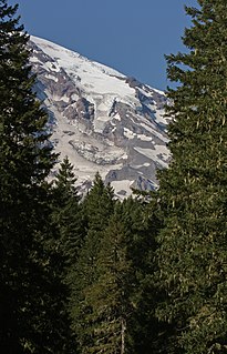
Little Tahoma Peak, also called Little Tahoma, is a satellite peak of Mount Rainier in Pierce County, Washington and in Mount Rainier National Park. It is quite noticeable from Seattle over 60 miles (97 km) away.

Monte Cristo Peak is a mountain peak in the Henry M. Jackson Wilderness in Washington state. Together with Columbia Peak and Kyes Peak it forms a basin that contains Columbia Glacier and Blanca Lake. The 1918 edition of The Mountaineer called the mountain "a huge pile of red rock."

Mount Index is a peak in the central part of the Cascade Range of Washington state. It lies just south of the Skykomish River and U.S. Route 2, at the western edge of the Cascades. Despite its low elevation relative to peaks higher in the Cascades, it is a famous and dramatic landmark due to its topographic prominence. It comprises three pointed spires which rise steeply from a very low base. The main peak is the southernmost of the three, while the North Peak rises even more steeply above the valley. For example, it rises more than 4,250 ft (1,300m) above the lower slopes on the northeast side in less than 1 horizontal mile (1.6 km).
Mount Pugh is a peak near the western edge of the North Cascades, in Washington state. It is located 12.2 miles (19.6 km) west of Glacier Peak, one of the Cascade stratovolcanoes. It rises out of the confluence of the White Chuck River and the Sauk River, giving it very low footings. For example, it rises 6,150 feet (1,875 m) above the Sauk River Valley in just over 2 horizontal miles (3.2 km); its rise over the White Chuck River is almost as dramatic. The mountain is named for John Pugh, who settled nearby, in 1891.

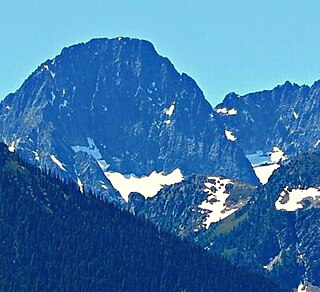
Whitehorse Mountain is a peak near the western edge of the North Cascades in Washington state. It is located just southwest of the Sauk River Valley town of Darrington, near the northern boundary of Boulder River Wilderness in Mount Baker-Snoqualmie National Forest. While not of particularly high absolute elevation, even for the North Cascades, it is notable for its large, steep local relief. For example, its north face rises 6,000 feet in only 1.8 mi (2.9 km).

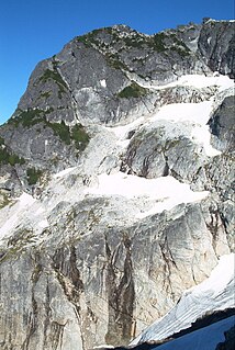
Johannesburg Mountain is one of the most famous peaks in the North Cascades of Washington state. Though not one of the top 100 peaks in the state by elevation, nor one of the top peaks as ranked by topographic prominence, Johannesburg is notable for its large, steep local relief, and particularly its immense, dramatic Northeast Face, which drops 5,000 feet in only 0.9 miles (1.4 km).

Dome Peak is a high, massive, glaciated mountain in the Glacier Peak Wilderness of Washington's North Cascades. The remote location of Dome Peak, combined with its height, make it a less common destination for Cascade Range mountaineers. Dome Peak is at the southern end of the Ptarmigan Traverse mountaineering route. It is located at the extreme southeast corner of Skagit County. The mountain was given its name by Albert H. Sylvester, the first forest supervisor of Wenatchee National Forest.

Barlow Pass is a mountain pass on the west side of the Cascades in Washington on the Mountain Loop Highway between Silverton and Darrington. It is a popular trail head for access to the old mining town of Monte Cristo and has a branch off to hike up to Gothic Basin, which is about a mile in.
The Kautz Glacier is a narrow glacier on the southern flank of Mount Rainier in Washington. Named for August Kautz, who is sometimes credited for the first ascent of Mount Rainier, covers 1.8 square miles (4.7 km2) and contains 7.8 billion ft3 of ice. Upper Kautz Glacier extends south from the summit ice cap to Kautz Ice Cliff at about 11,700 feet (3,600 m). Immediately west of the main ice cliff, the glacier continues down Kautz Chute which terminates in another ice cliff just above the lower Kautz Glacier at 10,800 feet (3,300 m). Usually reached by a short descent from Camp Hazard at 11,300 feet (3,400 m) on Wapowety Cleaver, climbers following the Kautz Glacier climbing route ascend this chute to the upper glacier.

Adams Glacier is situated on the northwest flank of Mount Adams, a 12,281-foot (3,743 m) stratovolcano in the U.S. state of Washington. Much of it becomes the source of Adams Creek, a tributary of the Cispus River. It is the largest glacier on Mount Adams, and the second largest in the contiguous United States, flowing down from the summit ice cap at over 12,000 feet (3,700 m) for over 2.5 miles (4.0 km) to a terminus near 7,000 feet (2,100 m).

Tolmie Peak is a 5,920+ -foot peak in the Mount Rainier area of the Cascade Range, in the U.S. state of Washington. It is located 2 miles (3.2 km) northwest of Mowich Lake, in the northwest part of Mount Rainier National Park.

Flora Mountain is a mountain summit in Washington in the Cascade Range in Washington state near the shores of Lake Chelan and 24 miles (39 km) south of the Canada–US border in the Glacier Peak Wilderness.

Austin S. Post was a photographer, glaciologist, and mountaineer known for his aerial photography of the mountains and glaciers of North America, particularly the North Cascades of Washington and Glacier Bay, Alaska.
Mesahchie Peak is in North Cascades National Park in the U.S. state of Washington. Mesahchie Peak is named after the Chinook word for wicked. Mesahchie Peak is the highest summit along a ridge known as Ragged Ridge and is only .25 mi (0.40 km) east of Katsuk Peak. Both the Katsuk and Mesahchie Glaciers descended down the northwest and northeast flanks of the peak respectively.
References
- Beckey, Fred (2000) [1973]. Columbia River to Stevens Pass. Cascade Alpine Guide. 1 (3rd ed.). Seattle, Washington: Mountaineers Books. ISBN 0-89886-577-8.
- Beckey, Fred (2003) [1973]. Stevens Pass to Rainy Pass. Cascade Alpine Guide. 2 (3rd ed.). Seattle, Washington: Mountaineers Books. ISBN 0-89886-152-7.
- Beckey, Fred (1995) [1981]. Rainy Pass to Fraser River. Cascade Alpine Guide. 3 (2nd ed.). Seattle, Washington: Mountaineers Books. ISBN 0-89886-423-2.
| | This article about a non-fiction book related to sports is a stub. You can help Wikipedia by expanding it. |