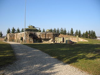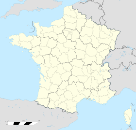
Ouvrage Schoenenbourg is a Maginot Line fortification. It is located on the territory of the communes of Hunspach, Schœnenbourg and Ingolsheim, in the French département of Bas-Rhin, forming part of the Fortified Sector of Haguenau, facing Germany. At the east end of the Alsace portion of the Maginot Line, its neighbour is the gros ouvrage Hochwald. It is the largest such fortification open to the public in Alsace. Officially recorded as an historical monument, it retains all its original structural elements. Schoenenbourg was heavily bombarded during the Battle of France in 1940, receiving more enemy ordnance than any other position in France, with no significant damage. In 1945, retreating German troops used explosives to destroy much of the ouvrage. After the war it was fully repaired and placed back into service as part of a programme to use Maginot fortifications to resist a potential Warsaw Pact advance through Europe. By the 1970s the plan had lost favour and funding, and Schoenenboug was abandoned. In 1987 a local organisation undertook Schoenenbourg's preservation, and today it is open to public visitation.

Ouvrage Hochwald is a gros ouvrage of the Maginot Line, one of the largest fortifications in the Line. Located on the Hochwald ridge in the Fortified Sector of Haguenau in the community of Drachenbronn-Birlenbach in the Bas-Rhin department of northeastern France, it was designed to protect the northern Vosges region of France. Ouvrage Hochwald is sometimes considered as two ouvrages because of its separation of the western and the eastern portions of the ouvrage. Uniquely, the original plans for the position included an elevated battery to the rear with long-range 145 mm or 155 mm gun turrets of a new kind. Hochwald is used by the French Air Force as an armoured air defense coordination center.
Ouvrage Coume Annexe Nord is a lesser work of the Maginot Line. Located in the Fortified Sector of Boulay, the ouvrage consists of one infantry block, and is located between petits ouvrages Village Coume and Coume, facing Germany.

Ouvrage Coume Annexe Sud is a lesser work of the Maginot Line. Located in the Fortified Sector of Boulay, the ouvrage consists of two infantry blocks, one artillery block and one observation block, and is located between petits ouvrages Coume and Mottemberg, facing Germany.
Ouvrage Mottenberg is a lesser work of the Maginot Line. Part of the Fortified Sector of Boulay, the ouvrage consists of one entrance block and two infantry blocks, and is located between petits ouvrages Coume Annexe Sud and Kerfent, facing Germany.

Ouvrage Einseling is a lesser work of the Maginot Line. Located in the Fortified Sector of Faulquemont, the ouvrage consists of one infantry block, and is located between petits ouvrages Bambesch and Laudrefang, facing Germany. Einseling faced a determined German attack on 21 June 1940, during the Battle of France. Unlike its less fortunate neighbors to the west, Einseling was able to resist the attack with help from Laudrefang, its neighbor to the east. The ouvrage survives in a heavily battered state, with its lower levels flooded.

Ouvrage Lembach is a petit ouvrage of the Maginot Line. Lembach is adjoined by petit ouvrage Grand Hohekirkel at some distance to its west and gros ouvrage Four-à-Chaux immediately to its east. It faces the German frontier, and was part of the Fortified Sector of the Vosges. During the Battle of France in 1940, the German 215th Infantry Division broke through the line of smaller fortifications to the west of Lembach, but did not directly attack. After aerial bombardments, Lembach surrendered with the rest of the Maginot fortifications according to the terms of the Second Armistice at Compiègne. After the war Lembach was renovated for further use, but was abandoned by the 1970s.

Ouvrage Four-à-Chaux is a gros ouvrage of the Maginot Line, located in the community of Lembach, France, in the Bas-Rhin département. Four à Chaux was adjoined by petit ouvrage Lembach and gros ouvrage Hochwald, and faced the German frontier as part of the Fortified Sector of the Vosges. A "four à chaux" is a lime kiln in French, and the ouvrage was located in the area of a limestone quarry and kiln, which operated until 1939. Four-à-Chaux was bombarded by the invading Germans in late June 1940 during the Battle of France with both aerial attacks and artillery bombardments. Four-à-Chaux survived to surrender at the end of the month. Block 1 was destroyed by the Germans before retreating in the face of American advances in 1945. During the 1950s Four-à-Chaux was renovated and reoccupied against a perceived threat from the Soviet Union. It fell out of use in the 1970s, and is now operated as a museum.
Ouvrage Eth is an isolated petit ouvrage of the Maginot Line, built as part of the "New Fronts" program to address shortcomings in the Line's coverage of the border with Belgium. It is located between the villages of Eth and Wargnies-le-Grand, in Nord département. Eth is the sole Maginot fortification in the Fortified Sector of the Escaut, which primarily consisted of individual casemates, blockhouses and the improved 19th-century Fort de Maulde. During the Battle of France the ouvrage resisted artillery attack for four days before the garrison evacuated through a drain to a neighboring casemate.
Ouvrage Les Sarts is a petit ouvrage of the Maginot Line, built as part of the "New Fronts" program to address shortcomings in the Line's coverage of the border with Belgium. Like the other three ouvrages near Maubeuge, it is built on an old Séré de Rivières system fortification, near the town of Marieux.
Ouvrage Bersillies is a petit ouvrage of the Maginot Line, built as part of the "New Fronts" program to address shortcomings in the Line's coverage of the border with Belgium. Like the other three ouvrages near Maubeuge, it is built on an old Séré de Rivières-system fortification, near the town of Bersillies. The preserved Ouvrage La Salmagne is nearby to the southeast. Bersillies is not open to the public.

Ouvrage Saint Ours Bas is a lesser work of the Maginot Line's Alpine extension, the Alpine Line. The ouvrage consists of one infantry block. The location is unusual in lacking the underground galleries typical of a Maginot fortification, making it more like a blockhouse than an ouvrage. It was armed with two machine gun cloches and three heavy twin machine guns and six light machine gun embrasures. The interior is laid out on two levels.
Ouvrage Col de la Valette is a lesser work of the Maginot Line's Alpine extension, the Alpine Line. The ouvrage is located at an altitude of 2,182 metres (7,159 ft). Apart from a portion of Block 3 and the bare gallery system, little was completed. The post overlooks the valley of the Tinée at Isola on one side, and Beuil on the other.
Ouvrage Vélosnes is a gros ouvrage of the Maginot Line, located in the Fortified Sector of Montmédy between the towns of Othe and Vélosnes, facing Belgium. It possesses four combat blocks and one entrance block. It is located to the east of petit ouvrage Thonnelle. The position was sabotaged and abandoned by French forces that were ordered to retreat from the exposed position in June 1940 during the Battle of France. The ouvrage is abandoned and is administered as a nature preserve.
The Fortified Sector of Flanders was the French military organization that in 1940 controlled the section of the French border with Belgium between Lille and the North Sea. The sector was part of a system of fortifications that, in other sectors, included the Maginot Line. In the case of the Flanders sector, no large fortifications of the kind typified by the Maginot Line were built in the area. Fortifications were confined to almost two hundred blockhouses built during the 1930s, and some defensive inundations in the vicinity of Dunkirk. The Fortified Sector of Flanders was bordered on the east by the Fortified Sector of Lille It was quickly overrun by German forces during the Battle of France.
The Fortified Sector of the Jura was the French military organization that in 1940 controlled the French frontier with Switzerland in the general area of Besançon. The area was lightly fortified, since the Swiss border was regarded as a low-risk frontier, save for the possibility of an advance from Germany through Switzerland into France. The Jura Mountains and the Doubs River presented natural barriers to invasion, allowing defenses to concentrate on a few points of potential access. The SF Jura was bordered on the east by the Fortified Sector of Montbéliard.

The Casemate de Marckolsheim Sud is a pre-World War II fortified position near the Rhine river in eastern France. The casemate was part of an extension of the Maginot Line fortifications along France's border with Germany. As a unit of the Fortified Sector of Colmar, the casemate was part of French defenses during the German assault of 15–18 June 1940, Operation Kleiner Bär. It has been preserved and is part of a museum focusing on the Rhine section of the Maginot Line. The museum is located at the eastern edge of the town of Marckolsheim.

The Fortified Sector of Haguenau was the French military organization that in 1940 controlled the most easterly section of the Maginot Line, to the north of Strasbourg. The left (western) wing of the Haguenau sector adjoined the Fortified Sector of the Vosges, includes two of the largest Maginot fortifications, Ouvrage Hochwald and Ouvrage Schoenenbourg. The right wing, started after 1931, was progressively scaled back in order to save money during the Great Depression, abandoning plans for four petit ouvrages and substituting casemates. The sector's northern and eastern sides bordered on Germany. To the south the sector borders the Fortified Sector of the Lower Rhine, from which it received several casemates in a boundary shift in 1940.

The Fortified Sector of the Vosges was the French military organization that in 1940 controlled the section of the Maginot Line at the northern end of the Vosges Mountains in northeastern France. The sector was bordered to the west by the Fortified Sector of Rohrbach and to the east by the Fortified Sector of Haguenau. The sector featured two gros ouvrages mounting heavy artillery at either end of the sector and one petit ouvrage mounting infantry weapons, linked by a line of casemates. The sector was attacked in 1940 by German forces in the Battle of France. German forces penetrated the casemate line and moved behind French lines. Despite the withdrawal of the mobile forces that supported the fixed fortifications, the three ouvrages successfully fended off German assaults before the Second Armistice at Compiègne, but were unable to hinder German activities to their south. The positions and their garrisons finally surrendered on 1 July 1940. Following the war several positions were reactivated for use during the Cold War. One position, Ouvrage Four-à-Chaux, is open to the public and may be visited.
The Casemate d'Oberroedern Sud, also known as Casemate Reiffel and Oberroedern Est, is a pre-World War II fortified position near the Rhine River in eastern France. The casemate was part of an extension of the Maginot Line fortifications along France's border with Germany. As a unit of the Fortified Sector of Haguenau, the casemate was part of French defences in June 1940. It has been preserved and is a component of a museum focusing on the Rhine section of the Maginot Line. The museum is located at the eastern edge of the town of Oberrœdern.


