
Arthur's Pass is a mountain pass in the Southern Alps of the South Island of New Zealand. The pass sits 920 metres or 3,020 feet above sea level and marks part of the boundary between the West Coast and Canterbury regions. Located 140 km from Christchurch and 95 km from Greymouth, the pass comprises part of a saddle between the valleys of the Ōtira River and of the Bealey River. Arthur's Pass lies on the border of the Selwyn and Westland districts.

The Waimakariri River is one of the largest rivers in Canterbury, on the eastern coast of New Zealand's South Island. It flows for 151 kilometres (94 mi) in a generally southeastward direction from the Southern Alps across the Canterbury Plains to the Pacific Ocean.

The Rangitata River is one of the braided rivers of the Canterbury Plains in southern New Zealand. It flows southeast for 120 kilometres (75 mi) from the Southern Alps, entering the Pacific Ocean 30 kilometres (19 mi) northeast of Timaru. The river has a catchment area of 1,773 square kilometres (685 sq mi), and a mean annual flow of 95 cubic metres per second (3,400 cu ft/s) at Klondyke.

Craigieburn is the name of a settlement and several geographic features in northwest Canterbury, in New Zealand's South Island.

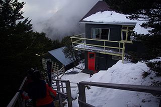
Cass is a small locality in inland Canterbury on New Zealand's South Island, near Arthur's Pass. It is known for its small railway station which was the subject of the 1936 painting Cass by Rita Angus, voted in 2006 New Zealand's favourite work of art. It is also the location of a University of Canterbury field station established in 1914. Cass currently has a single permanent resident.

The Harper River is a tributary of the Wilberforce River which itself flows into the Rakaia River in New Zealand's Canterbury region. It is located in the Southern Alps and a pass in the Harper River headwaters leads into the Waimakariri River catchment. One of the most popular tramping routes in Canterbury enters the East Harper via Cass Saddle and exits via Lagoon Saddle at the head of the West Harper.
Broken River is a club skifield in South Island, New Zealand. Run by the Broken River Ski Club, it is located at about 110 km (68 mi) from Christchurch. The skifield claims to often have the longest ski season anywhere in Australasia. Also, by connecting with Craigieburn Valley, it claims to have the largest skiable area in New Zealand, at 900 hectares.

Porters, is a commercial ski resort just over an hour's drive (98 km) west from Christchurch, in the South Island of New Zealand. Originally functioning as a club skifield, it has one beginner magic carpet, one platter tow, one chairlift and three t-bars. The difficulty of the slopes is distributed as 15% beginner, 35% intermediate and 50% advanced. Modern grooming equipment is used, and snowmaking facilities operate along the main pistes along the chairlift.
The Craigieburn Range forms part of the Southern Alps in New Zealand's South Island. The range is located on the south banks of the Waimakariri River, south of Arthur's Pass and west of State Highway 73. The Craigieburn locality is adjacent to the Craigieburn Forest Park.

Craigieburn Forest Park is a protected area in the South Island of New Zealand, adjacent to Arthur's Pass National Park to the north.
Avoca is a locality in the Canterbury region of New Zealand. It is situated along the Midland Railway Line between Craigieburn and Staircase. There are no permanent residents, but it once supported a small number of railway staff.
The Goldney River is a river in the Canterbury region of New Zealand. It arises on the southern slopes of the Craigieburn Range and flows south into Lake Coleridge. The Goldney family were early squatters in the area.
The Porter River is a river of the Canterbury Region of New Zealand's South Island. It rises close to the southern end of the Craigieburn Range east of Lake Coleridge, flowing generally northeast to reach the Broken River close to Castle Hill. The Porters Ski Area is above the river valley's western flank, and State Highway 73 follows the river's course for some distance to the west of Porters Pass.
The Ryton River is a river of the Canterbury region of New Zealand's South Island. It flows southwest down a long valley within the Craigieburn Range to reach the northeastern shore of Lake Coleridge.
Canterbury's Esk River is a tributary of the Waimakariri River. It rises in the Dampier Range near Esk Head, and flows southwest on the western side of the Puketeraki Range to reach the upper Waimakariri some 20 kilometres (12 mi) north of Springfield.
Flock Hill station is located in New Zealand's South Island high country, in the Waimakariri River basin, 75 minutes drive from Christchurch on State Highway 73 which is now commonly known as The Great Alpine Highway between Castle Hill Station and Cass near Lake Pearson.
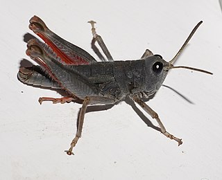
Sigaus villosus is New Zealand's largest grasshopper. It is only found in the central mountains of the South Island. The genus Sigaus is endemic to the New Zealand. Like all of New Zealand sub-alpine and alpine grasshoppers S. villosus has a 2 or 3 years life cycle. The eggs must ‘overwinter’ before they will hatch. Hoppers are found throughout the year and adult grasshoppers can be found throughout the New Zealand summer between December and April. Adult S. villosus do not overwinter.

Captain Joseph Thomas (1803–?) was a British explorer and the chief surveyor for Lyttelton, Sumner and Christchurch in New Zealand. He took up surveying after service in the British army, gaining the rank of lieutenant. In the 1840s, he explored many parts of New Zealand and worked for the New Zealand Company. This gained him employment with the Canterbury Association, which sent him to New Zealand in 1848. Thomas' role was to find a suitable site for their proposed settlement, and what became the Canterbury region with Christchurch as its capital was the result of his efforts. He was dismissed in early 1851 over quarrels with John Robert Godley, the agent of the Canterbury Association, just after the first settlers had arrived in the colony. Thomas' life after 1853 is unknown. Having allowed for Hagley Park as a generous central city green space is regarded as his major achievement, and it is his lasting legacy.

The RangitataGorge is a gorge located in the Canterbury High Country in the South Island of New Zealand. The narrow gorge links the headwaters of the Rangitata River with the fertile Canterbury Plains. The Rangitata gorge is commercially rafted by a local company. It is also a popular river for visiting kayakers, fishermen and adventurist locals in jet boats. The gorge is a class IV to V+ depending on the flow of the river and home to the notable rapids including Rooster's Tail, Pencil Sharpener, The Pinch, Pigs Trough and Hells Gate.

Korowai / Torlesse Tussocklands Park is a protected area in Canterbury, New Zealand. Covering around 21,000 hectares, it is located on both sides of State Highway 73, from east of Porters Pass to south of Castle Hill Village.

