
Powys is a county and preserved county in Wales. It borders Gwynedd, Denbighshire, and Wrexham to the north; the English ceremonial counties of Shropshire and Herefordshire to the east; Monmouthshire, Blaenau Gwent, Merthyr Tydfil, Caerphilly, Rhondda Cynon Taf, and Neath Port Talbot to the south; and Carmarthenshire and Ceredigion to the west. The largest settlement is Newtown, and the administrative centre is Llandrindod Wells.
National Cycle Network, Route 43 is part of the National Cycle Network and the Celtic Trail, which connects Swansea with Builth Wells. Most of the route is still awaiting development. As of June 2006, there is a 13-mile section out of Swansea that is open and signed.

Corn Du is a summit of the twin topped Pen y Fan and the second highest peak in South Wales at 871.5 m (2,864 ft), situated in the Brecon Beacons National Park. The summit itself is marked by a well structured Bronze Age cairn with a central burial cist like that on nearby Pen y Fan. The two summits are visible from great distances owing to their height above the surrounding moorland, and are famous landmarks. The views from the peaks are also panoramic and very extensive, the Black Mountain and Fforest Fawr being especially obvious to the west. Mynydd Epynt is visible to the north behind the county town of Brecon, and other parts of the escarpment to the east.

Mynydd Epynt is a former community and upland area in Powys, Wales.

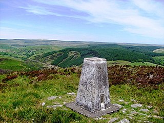
Mynydd Illtud is an extensive area of common land near Libanus, Powys, Wales, located in the Brecon Beacons National Park and some three miles south-west of Brecon. The common is an undulating plateau lying between 330 and 370 metres above sea level. Its highest points are 381 metres (1,250 ft) at Allt Lom and 367 metres (1,204 ft) at Twyn y Gaer trig point overlooking the valley of the River Usk. Twyn y Gaer is the site of an Iron Age hill fort.

Picws Du is the second highest peak of the Carmarthen Fans in the Carmarthenshire section of the Black Mountain in the west of the Brecon Beacons National Park in south Wales. The highest peak is Fan Foel immediately next along the ridge and it is a subsidiary summit of Fan Brycheiniog. Picws Du falls within Fforest Fawr Geopark and its prominent summit is marked by a large Bronze Age round barrow at a height of 2457 feet above sea level. Waun Lefrith is the other, lower summit of the Bannau Sir Gâr / Carmarthen Fans situated to the west. The peak overlooks the glacial lake of Llyn y Fan Fach in the cwm below. As the peak sits on the edge of the escarpment on a ridge which juts out into the valley below, the views from the summit are panoramic and extensive. The views to the north are especially impressive when the weather is clear, looking towards the Cambrian Mountains, Mynydd Epynt and Brecon. Swansea and the Bristol Channel can just be seen on the horizon to the south, across the gently falling dip slope. Pen y Fan and Corn Du are distinctive landmarks seen directly to the east across Fforest Fawr.

The River Honddu is a river in the county of Powys, mid Wales. Early recorded versions of the name are of the form Hothenei and hodni which are believed to contain the Welsh adjective 'hawdd', meaning 'pleasant' or 'easy', together with a suffix -ni. Later forms such as Honddey and Honthy have undergone metathesis whereby -ddn- became -ndd-.

The Afon Ysgir is a river which rises on the southern slopes of Mynydd Epynt in Powys, Wales. The tributaries known as Ysgir Fawr and Ysgir Fechan flow past the hamlets of Pont Rhyd-y-berry and Merthyr Cynog to combine at Pont-faen and continue past the village of Battle to join the River Usk at Aberyscir.
The Nant Brân is a short river which rises on the southern slopes of Mynydd Epynt in Powys, Wales. The word 'brân' means 'crow' in Welsh: the name may therefore allude to the dark colour of its waters.
Libanus is a village in the Brecon Beacons National Park, Powys, Wales, United Kingdom, and in the community of Glyn Tarell. Presumably, the name of the village derives from Mount Lebanon, also known as the Lebanon Mountains, the ancient name for which was Libanus, a common name for chapels in Wales.
The Brecon Forest Tramroad is an early nineteenth century tramroad, or rather a network of connecting tramroads or waggonways, which stretched across the hills of Fforest Fawr in the historic county of Brecknockshire in south Wales, UK. Its northern terminus was at the village of Sennybridge in the Usk Valley whilst its southern ends lay at Abercraf and Ystradgynlais in the upper Swansea Valley some 20 km to the south.
Upper Chapel is a hamlet in the southern part of the county of Powys in mid Wales. It was formerly in the county of Brecknockshire. It lies on the B4520 road from Brecon to Builth Wells, in the valley of the River Honddu. The south-flowing Honddu cuts deeply into the uplands of Mynydd Epynt north of Brecon. To the north and west of Upper Chapel lies the British Army's Sennybridge Training Area.

Merthyr Cynog is a hamlet and a community in the modern county of Powys, Wales, in the historic county of Brecknockshire. The population of the community at the 2011 Census was 245.

Duhonw is a rural community in Powys, Wales, to the south of Builth Wells, in the historic county of Breconshire. Covering an area of 4,376 hectares (16.90 sq mi) and including scattered farms and dwellings, it is bounded to its north by the Afon Irfon, to its south by Mynydd Epynt and Banc y Celyn (472m) and to its east the rivers Duhonw and Wye. Llangammarch Wells' is to its west.
Mynydd Mallaen is an expansive plateau to the northwest of Cilycwm in northeast Carmarthenshire, Wales. It forms part of the Cambrian Mountains massif, and is north-west of the Black Mountain (range) in the Brecon Beacons. It takes the form of an undulating plateau with steep slopes dropping away to the Towy valley to the east and those of the Gwenffrwd, Nant Melyn and Afon Cothi to the north and west. Its highest point of 1516 feet or 462m at OS grid reference SN 723455 is surmounted by two Bronze Age cairns known as Crugiau Merched. Caeo Forest covers much of the southern flanks of the hill and smaller forests also cover its eastern slopes. Much of the native woodland consists of sessile oak groves, especially on the valley sides. The human population is very low, being restricted to hill farms engaged in sheep farming, and some holiday cottages.
Soar is a small village in Powys, Wales, 37 miles North West of Cardiff. It sits at the foot of Mynydd Epynt, and is near Brecon in the historic county of Brecknockshire. The nearby settlement of Ffinnant - divided into the hamlets of Upper Ffinnant and Lower Ffinnant - may have been the site of the Battle of Ffinnant at which Ithel ap Hywel was killed.
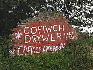
Cofiwch Dryweryn or Wal Cofiwch Dryweryn is a graffitied stone wall near Llanrhystud, Ceredigion, Wales. Author and journalist Meic Stephens originally painted the words onto the wall of a ruined cottage in the early 1960s following the decision by the Liverpool City Council to commence the Tryweryn flooding, including the community of Capel Celyn to create the Llyn Celyn reservoir. Due to its prominent location, stark message, and history of repeated vandalism, the wall has become an unofficial landmark of mid Wales. The phrase "Cofiwch Dryweryn" has itself become a prominent political slogan for Welsh nationalism, appearing on T-shirts and banners, and as replica murals.
The Afon Cilieni is a short river which rises on the southern slopes of Mynydd Epynt in Powys, Wales. The name may mean ' the river rising in a small nook'.

The Epynt clearance was the forced eviction of the Mynydd Epynt community in Powys, Wales, where 200 men, women and children were evicted from their homes which included 54 farms and a pub. The eviction was carried out by the British Army and the War Office in 1940, creating the Sennybridge Training Area (SENTA), which is currently the largest military training area in Wales.
