
The Firth of Clyde is the estuary of the River Clyde, on the west coast of Scotland. The Firth has some of the deepest coastal waters of the British Isles. The Firth is sheltered from the Atlantic Ocean by the Kintyre Peninsula. The Firth lies between West Dunbartonshire in the north, Argyll and Bute in the west and Inverclyde, North Ayrshire and South Ayrshire in the east. The Kilbrannan Sound is a large arm of the Firth, separating the Kintyre Peninsula from the Isle of Arran. The Kyles of Bute separates the Isle of Bute from the Cowal Peninsula. The Sound of Bute separates the islands of Bute and Arran.
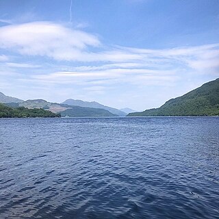
Loch Lomond is a freshwater Scottish loch which crosses the Highland Boundary Fault, often considered the boundary between the lowlands of Central Scotland and the Highlands. Traditionally forming part of the boundary between the counties of Stirlingshire and Dunbartonshire, Loch Lomond is split between the council areas of Stirling, Argyll and Bute and West Dunbartonshire. Its southern shores are about 23 kilometres (14 mi) northwest of the centre of Glasgow, Scotland's largest city. The Loch forms part of the Loch Lomond and The Trossachs National Park which was established in 2002.

Loch Leven is a fresh water loch located immediately to the east of the burgh of Kinross in Perth and Kinross council area, central Scotland. Roughly triangular, the loch is about 6 km (3.7 mi) at its longest. Prior to the canalisation of the River Leven, and the partial draining of the loch in 1826–36, Loch Leven was considerably larger. The drop in water level by 1.4 m reduced the loch to 75% of its former size, and exposed several small islands, as well as greatly increasing the size of the existing ones.

Loch Fleet is a sea loch on the east coast of Scotland, located between Golspie and Dornoch. It forms the estuary of the River Fleet, a small spate river that rises in the hills east of Lairg. The loch was designated a National Nature Reserve (NNR) in 1998, and is managed by a partnership between NatureScot, the Scottish Wildlife Trust (SWT) and Sutherland Estates. The NNR extends to 1058 hectares, including the Loch Fleet tidal basin, sand dunes, shingle ridges and the adjacent pine woods, including Balbair Wood and Ferry Wood. The tidal basin of the loch covers over 630 ha, and forms the largest habitat on the NNR.
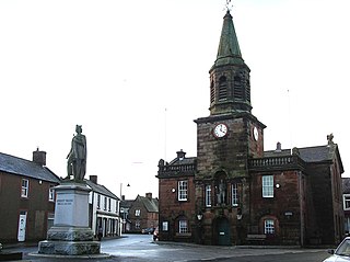
Lochmaben is a small town and civil parish in Scotland, and site of a castle. It lies 4 miles (6 km) west of Lockerbie, in Dumfries and Galloway. By the 12th century the Bruce family had become the local landowners and, in the 14th century, Edward I rebuilt Lochmaben Castle. It was subsequently taken by Archibald Douglas, 3rd Earl of Douglas in 1384/5 and was abandoned in the early 17th century. The town itself became a Royal Burgh in 1447.
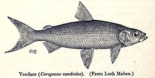
Coregonus vandesius, the vendace, is a freshwater whitefish found in the United Kingdom. Population surveys since the 1960s have revealed a steady decline and the fish is no longer present in some of its previous haunts but is still present in Bassenthwaite Lake and Derwent Water. The main threats it faces are eutrophication and the introduction of alien species of fish which eat its eggs and fry. The International Union for Conservation of Nature has rated its conservation status as "endangered".

Loch Ruthven is a large loch which lies to the southeast of Loch Ness in the Highland region of Scotland. It is 2.25 miles (3.62 km) long, extends over an area of 368 acres (149 ha) and is up to 42 feet (13 m) deep. The most important breeding site in the UK for Slavonian grebes, it has one of the highest populations of this species in Europe. These rare birds can also be found in several other local lochs. The RSPB has established a reserve at Loch Ruthven.
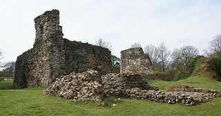
Lochmaben Castle is a ruined castle in the town of Lochmaben, the feudal Lordship of Annandale, and the united county of Dumfries and Galloway. It was built by Edward I in the 14th century replacing an earlier motte and bailey castle, and later rebuilt during the reign of James IV of Scotland. The earlier motte-and-bailey castle was built south of the current castle in c. 1160 by the Bruce family, Lords of Annandale.

The Annandale Way is a 90-kilometre (56 mi) hiking trail in Scotland, which is officially designated by NatureScot as one of Scotland's Great Trails. It follows the valley of the River Annan from its source in the Moffat Hills to the sea in the Solway Firth south of the town of Annan. The route, which was established on 12 September 2009, has been designed to be traversable in four to five days as a continuous walk but it also offers several day-walks. Overnight stops can be arranged in small market towns and villages along the route such as Moffat, Johnstonebridge, Lochmaben, Lockerbie, or Annan. The route has been developed by Sulwath Connections and local communities, with the support of local estates and farmers, to help promote Annandale as a new area for walking. Its trailheads are near the Devil's Beef Tub in the Moffat Hills and on the Solway Firth just south of Annan, in Newbie.
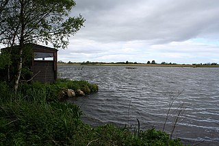
Lochmaben Castle was a 12th-century castle on the spit of land between Loch Kirk and Loch Castle, in Lochmaben, Scotland.
Bridgend Flats is an area of mudflats and saltmarsh near the village of Bridgend on the island of Islay off the west coast of Scotland. Covering an area of 331 hectares, it is situated around the outflow of the River Sorn into Loch Indaal.

Cameron Reservoir is an artificial loch in the parish of Cameron in east Fife, Scotland. Covering an area of 69 hectares, it serves as a domestic water supply and contains beds of aquatic and marginal vegetation.

The Kintyre Goose Roosts are a group of five oligotrophic hill lochs on the Kintyre peninsula in Argyll and Bute, western Scotland. With a total area of 312 hectares, they have been protected as a Ramsar Site since 1998.
Loch an Duin is a complex system of freshwater, brackish and sea lochs, tidal channels and islands, on and close to North Uist off the west coast of Scotland. An area of 2,621 hectares has been protected since 1990 as a Ramsar Site.

Loch Eye is a shallow freshwater loch, located close to the east coast of Scotland between the Moray Firth, Dornoch Firth and Cromarty Firth. Covering an area of 205 hectares, it is an important site for waterfowl and has been protected since 1986 as a Ramsar Site, a Special Protection Area and a Site of Special Scientific Interest.

Loch of Lintrathen is a man-made loch occupying a glacial basin at the southern end of Glen Isla, approximately 13 kilometres (8.1 mi) west of town of Kirriemuir in Angus, Scotland.

Loch of Kinnordy is a small loch located just west of town of Kirriemuir in Angus, Scotland, which is an important wildlife habitat. The loch itself is approximately 22 hectares, though this has varied over time with drainage attempts and the silting up of the outflow stream. Including surrounding fen, swamp and mire, 85 hectares are protected as a Ramsar Site.
Loch Spynie is a small loch located between the towns of Elgin and Lossiemouth in Moray, Scotland. Close to Spynie Palace, the ancient home of the bishops of Moray, it is an important wildlife habitat which is protected as a Ramsar Site.

South Tayside Goose Roosts is a composite wetland site to the west of Perth in central Scotland, covering a total of 331 hectares, which has been protected as a Ramsar Site since 1993. Incorporating three disconnected sections, separated by several kilometres, the site contains seven freshwater lochs along with other wetland habitats, including one of the largest raised bogs in the region.

The South Uist Machair and Lochs is a protected wetland area on the west coast of South Uist in the Outer Hebrides of Scotland. A total of 5,019 hectares contains blanket bog, oligotrophic lochs, wet and dry machair, fresh and saltwater marsh, coastal dunes and sandy and rocky shores. It includes the estuary waters of the Howmore River, as well as Loch Bi and Loch Druidibeg. It has been protected as a Ramsar Site since 1976.

