Related Research Articles
A townland is a small geographical division of land, historically and currently used in Ireland and in the Western Isles in Scotland, typically covering 100–500 acres (40–202 ha). The townland system is of Gaelic origin, antedating the Norman invasion, and most have names of Irish origin. However, some townland names and boundaries come from Norman manors, plantation divisions, or later creations of the Ordnance Survey. The total number of inhabited townlands in Ireland was 60,679 in 1911. The total number recognised by the Irish Place Names database as of 2014 was 61,098, including uninhabited townlands, mainly small islands.

Dundonald is a large settlement and civil parish in County Down, Northern Ireland, United Kingdom. It lies east of Belfast and is often considered a suburb of the city. It is home to the Ulster Hospital, Dundonald International Ice Bowl, Dundonald Omnipark, has a Park and Ride facility for the Glider, access to the Comber Greenway and several housing developments. John de Courcey established a keep including a motte-and-bailey in the 12th century. This is known as Moat Park and can be accessed from Church Green, Comber Road and the Upper Newtownards Road.

Saul is a village in County Down, Northern Ireland, within the civil parish of Saul and Ballee.

Drumbeg is a small village, townland and civil parish on the south bank of the River Lagan in County Down, Northern Ireland. The village is covered by the Lisburn City Council area and forms part of the suburban fringe of Belfast.
Lambeg is a small village and civil parish in County Antrim, Northern Ireland. Located between Belfast and Lisburn, it was once a small rural village, but is now within the Greater Belfast conurbation. Lambeg is also an electoral ward of Lisburn Council. In the 2001 Census it had a population of 60 people. The civil parish of Lambeg covers areas of County Down as well as County Antrim.

Tullylish is a small village, townland and civil parish in County Down, Northern Ireland. It sits on the River Bann, along the main road between the towns of Banbridge and Portadown. In the 2001 census it had a population of 105 people. It lies within the civil parish of Tullylish and Banbridge District.

Kilcoo is a small village and civil parish in County Down, Northern Ireland. It lies between Rathfriland and Castlewellan and is within the Newry, Mourne and Down District Council area. The village is on the A25 Dublin Road 6 kilometres (4 mi) south-west of Castlewellan. Kilcoo had a population 1415 people in the 2001 Census.
Derry is a townland in the civil parish of Ballyphilip in the barony of Ards Upper, County Down, in Northern Ireland. It is near Portaferry on the Ards Peninsula. The townland has remains of two small ruined churches.
Kilcronaghan is a civil parish in County Londonderry, Northern Ireland. Containing one major settlement, Tobermore, and lying on the descending slope of Slieve Gallion, Kilcronaghan is bordered by the civil parishes of Ballynascreen, Desertmartin, Maghera, and Termoneeny. It lies within the former historic barony of Loughinsholin and is situated in Mid-Ulster District. As an ecclesiastical parish it lies within the Diocese of Derry and Raphoe.
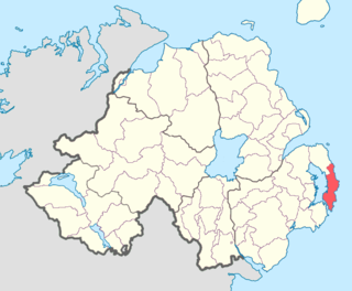
Ards Upper is a barony in County Down, Northern Ireland. It lies on the southern half of the Ards Peninsula in the east of the county, with the Irish Sea to its east and Strangford Lough to its west. It is bordered by two other baronies: Ards Lower to the north; and Lecale Lower just across the mouth of Strangford Lough to the south.
Bangor is a civil and ecclesiastical parish in County Down, Northern Ireland. It is located in the north of the Ards Peninsula, consisting of 30 townlands, twenty-two and a half of which lie in the barony of Ards Lower, with seven and a half lying within that of Castlereagh Lower. Its ancient monastery was of ecclesiastical importance.

Tullynakill is a civil parish and townland in County Down, Northern Ireland. It is situated in the historic barony of Castlereagh Lower.
Inishargy is a civil parish and townland in County Down, Northern Ireland. It is situated in the historic barony of Ards Upper.
Ballee is a civil parish in County Down, Northern Ireland. It is situated mainly in the historic barony of Lecale Lower, with one townland in the barony of Lecale Upper.

Bright is a civil parish in County Down, Northern Ireland. It is situated in the historic barony of Lecale Upper. It is also a townland of 336 acres.
Down is a civil parish in County Down, Northern Ireland. It is situated in the historic barony of Lecale Upper.
References
- 1 2 3 "Castleboy". IreAtlas Townlands Database. Retrieved 16 May 2015.