
Drainage is the natural or artificial removal of a surface's water and sub-surface water from an area with excess water. The internal drainage of most agricultural soils can prevent severe waterlogging, but many soils need artificial drainage to improve production or to manage water supplies.

A drainage basin is an area of land where all flowing surface water converges to a single point, such as a river mouth, or flows into another body of water, such as a lake or ocean. A basin is separated from adjacent basins by a perimeter, the drainage divide, made up of a succession of elevated features, such as ridges and hills. A basin may consist of smaller basins that merge at river confluences, forming a hierarchical pattern.

Stormwater, also written storm water, is water that originates from precipitation (storm), including heavy rain and meltwater from hail and snow. Stormwater can soak into the soil (infiltrate) and become groundwater, be stored on depressed land surface in ponds and puddles, evaporate back into the atmosphere, or contribute to surface runoff. Most runoff is conveyed directly as surface water to nearby streams, rivers or other large water bodies without treatment.
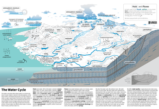
The water cycle, also known as the hydrologic cycle or the hydrological cycle, is a biogeochemical cycle that describes the continuous movement of water on, above and below the surface of the Earth. The mass of water on Earth remains fairly constant over time but the partitioning of the water into the major reservoirs of ice, fresh water, saline water and atmospheric water is variable depending on a wide range of climatic variables. The water moves from one reservoir to another, such as from river to ocean, or from the ocean to the atmosphere, by the physical processes of evaporation, transpiration, condensation, precipitation, infiltration, surface runoff, and subsurface flow. In doing so, the water goes through different forms: liquid, solid (ice) and vapor. The ocean plays a key role in the water cycle as it is the source of 86% of global evaporation.
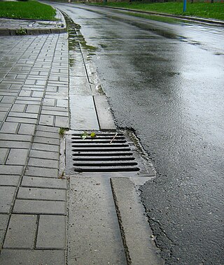
A storm drain, storm sewer, surface water drain/sewer, or stormwater drain is infrastructure designed to drain excess rain and ground water from impervious surfaces such as paved streets, car parks, parking lots, footpaths, sidewalks, and roofs. Storm drains vary in design from small residential dry wells to large municipal systems.

Permeable paving surfaces are made of either a porous material that enables stormwater to flow through it or nonporous blocks spaced so that water can flow between the gaps. Permeable paving can also include a variety of surfacing techniques for roads, parking lots, and pedestrian walkways. Permeable pavement surfaces may be composed of; pervious concrete, porous asphalt, paving stones, or interlocking pavers. Unlike traditional impervious paving materials such as concrete and asphalt, permeable paving systems allow stormwater to percolate and infiltrate through the pavement and into the aggregate layers and/or soil below. In addition to reducing surface runoff, permeable paving systems can trap suspended solids, thereby filtering pollutants from stormwater.
In hydrology, discharge is the volumetric flow rate of a stream. It equals the product of average flow velocity and the cross-sectional area. It includes any suspended solids, dissolved chemicals, or biologic material in addition to the water itself. Terms may vary between disciplines. For example, a fluvial hydrologist studying natural river systems may define discharge as streamflow, whereas an engineer operating a reservoir system may equate it with outflow, contrasted with inflow.

Agricultural wastewater treatment is a farm management agenda for controlling pollution from confined animal operations and from surface runoff that may be contaminated by chemicals in fertilizer, pesticides, animal slurry, crop residues or irrigation water. Agricultural wastewater treatment is required for continuous confined animal operations like milk and egg production. It may be performed in plants using mechanized treatment units similar to those used for industrial wastewater. Where land is available for ponds, settling basins and facultative lagoons may have lower operational costs for seasonal use conditions from breeding or harvest cycles. Animal slurries are usually treated by containment in anaerobic lagoons before disposal by spray or trickle application to grassland. Constructed wetlands are sometimes used to facilitate treatment of animal wastes.
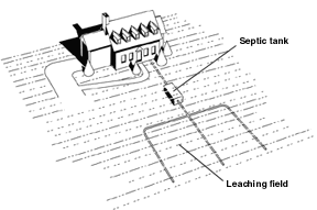
Septic drain fields, also called leach fields or leach drains, are subsurface wastewater disposal facilities used to remove contaminants and impurities from the liquid that emerges after anaerobic digestion in a septic tank. Organic materials in the liquid are catabolized by a microbial ecosystem.

Infiltration is the process by which water on the ground surface enters the soil. It is commonly used in both hydrology and soil sciences. The infiltration capacity is defined as the maximum rate of infiltration. It is most often measured in meters per day but can also be measured in other units of distance over time if necessary. The infiltration capacity decreases as the soil moisture content of soils surface layers increases. If the precipitation rate exceeds the infiltration rate, runoff will usually occur unless there is some physical barrier.

A catchwater device is a large-scale man-made device for catching surface runoff from hills and the sky from precipitation by channeling it to reservoirs for commercial and domestic use later. Freshwater is a scarce natural resource due to pollution, droughts, and overpopulation. Catchwater is a sustainable mechanism to increase freshwater in areas facing droughts or polluted waterways. A catchwater drain decreases the velocity of storm-water runoff to reduce and prevent erosion and other environmental problems.

Rain gardens, also called bioretention facilities, are one of a variety of practices designed to increase rain runoff reabsorption by the soil. They can also be used to treat polluted stormwater runoff. Rain gardens are designed landscape sites that reduce the flow rate, total quantity, and pollutant load of runoff from impervious urban areas like roofs, driveways, walkways, parking lots, and compacted lawn areas. Rain gardens rely on plants and natural or engineered soil medium to retain stormwater and increase the lag time of infiltration, while remediating and filtering pollutants carried by urban runoff. Rain gardens provide a method to reuse and optimize any rain that falls, reducing or avoiding the need for additional irrigation. A benefit of planting rain gardens is the consequential decrease in ambient air and water temperature, a mitigation that is especially effective in urban areas containing an abundance of impervious surfaces that absorb heat in a phenomenon known as the heat-island effect.

Nonpoint source (NPS) pollution refers to diffuse contamination of water or air that does not originate from a single discrete source. This type of pollution is often the cumulative effect of small amounts of contaminants gathered from a large area. It is in contrast to point source pollution which results from a single source. Nonpoint source pollution generally results from land runoff, precipitation, atmospheric deposition, drainage, seepage, or hydrological modification where tracing pollution back to a single source is difficult. Nonpoint source water pollution affects a water body from sources such as polluted runoff from agricultural areas draining into a river, or wind-borne debris blowing out to sea. Nonpoint source air pollution affects air quality, from sources such as smokestacks or car tailpipes. Although these pollutants have originated from a point source, the long-range transport ability and multiple sources of the pollutant make it a nonpoint source of pollution; if the discharges were to occur to a body of water or into the atmosphere at a single location, the pollution would be single-point.

Surface runoff is the unconfined flow of water over the ground surface, in contrast to channel runoff. It occurs when excess rainwater, stormwater, meltwater, or other sources, can no longer sufficiently rapidly infiltrate in the soil. This can occur when the soil is saturated by water to its full capacity, and the rain arrives more quickly than the soil can absorb it. Surface runoff often occurs because impervious areas do not allow water to soak into the ground. Furthermore, runoff can occur either through natural or human-made processes.
Landslide mitigation refers to several human-made activities on slopes with the goal of lessening the effect of landslides. Landslides can be triggered by many, sometimes concomitant causes. In addition to shallow erosion or reduction of shear strength caused by seasonal rainfall, landslides may be triggered by anthropic activities, such as adding excessive weight above the slope, digging at mid-slope or at the foot of the slope. Often, individual phenomena join to generate instability over time, which often does not allow a reconstruction of the evolution of a particular landslide. Therefore, landslide hazard mitigation measures are not generally classified according to the phenomenon that might cause a landslide. Instead, they are classified by the sort of slope stabilization method used:

Surface water is water located on top of land, forming terrestrial waterbodies, and may also be referred to as blue water, opposed to the seawater and waterbodies like the ocean.

Loch Errochty is a man made freshwater loch situated within the Perth and Kinross council area at the edge of the Scottish Highlands near the Highland Boundary Fault where the topography changes to lowland.
The Witham Navigable Drains are located in Lincolnshire, England, and are part of a much larger drainage system managed by the Witham Fourth District Internal Drainage Board. The Witham Fourth District comprises the East Fen and West Fen, to the north of Boston, which together cover an area of 97 square miles (250 km2). In total there are over 438 miles (705 km) of drainage ditches, of which under 60 miles (97 km) are navigable. Navigation is normally only possible in the summer months, as the drains are maintained at a lower level in winter, and are subject to sudden changes in level as a result of their primary drainage function, which can leave boats stranded. Access to the drains is from the River Witham at Anton's Gowt Lock.

Stormwater harvesting or Stormwater reuse is the collection, accumulation, treatment or purification, and storage of stormwater for its eventual reuse. While rainwater harvesting collects precipitation primarily from rooftops, stormwater harvesting deals with collection of runoff from creeks, gullies, ephemeral streams, underground conveyances. It can also include catchment areas from developed surfaces, such as roads or parking lots, or other urban environments such as parks, gardens and playing fields.

The River Torne is a river in the north of England, which flows through the counties of South Yorkshire and North Lincolnshire. It rises at the Upper Lake at Sandbeck Hall, in Maltby in South Yorkshire, and empties into the River Trent at Keadby pumping station. Much of the channel is engineered, as it plays a significant role in the drainage of Hatfield Chase, which it crosses.
