Related Research Articles

The Guiana Shield is one of the three cratons of the South American Plate. It is a 1.7 billion-year-old Precambrian geological formation in northeast South America that forms a portion of the northern coast. The higher elevations on the shield are called the Guiana Highlands, which is where the table-like mountains called tepuis are found. The Guiana Highlands are also the source of some of the world's most well-known waterfalls such as Angel Falls, Kaieteur Falls and Cuquenan Falls.
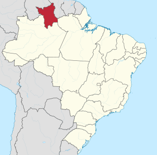
Roraima is one of the 26 states of Brazil. Located in the country's North Region, it is the northernmost and most geographically and logistically isolated state in Brazil. It is bordered by the state of Pará to the southeast, Amazonas to the south and west, Venezuela to the north and northwest, and Guyana to the east.
Mount Roraima is the highest of the Pakaraima chain of tepuis or plateaux in South America. It is located at the junction of Venezuela, Brazil and Guyana. A characteristic large flat-topped mountain surrounded by cliffs 400 to 1,000 meters high. The highest point of Mount Roraima is located on the southern edge of the cliff at an altitude of 2,810 meters in Venezuela, and another protrusion at an altitude of 2,772 meters at the junction of the three countries in the north of the plateau is the highest point in Guyana. The name of Mount Roraima came from the native Pemon people. Roroi in the Pemon language means "blue-green", and ma means "great".
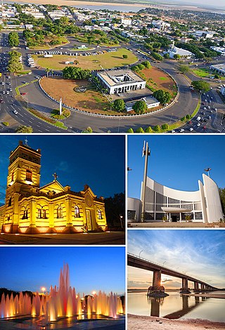
Boa Vista is the capital of the Brazilian state of Roraima. Situated on the western bank of the Branco River, the city lies 220 km (140 mi) from Brazil's border with Venezuela. It is the only Brazilian state capital located entirely north of the equator.

Canaima National Park is a 30,000 km2 (12,000 sq mi) park in south-eastern Venezuela that roughly occupies the same area as the Gran Sabana region. It is located in Bolívar State, reaching the borders with Brazil and Guyana. The park was named a World Heritage Site by UNESCO.
The Campeonato Roraimense is the football league of the state of Roraima, Brazil.

The Oyapock or Oiapoque is a 403-kilometre (250 mi) long river in South America that forms most of the border between the French overseas department of French Guiana and the Brazilian state of Amapá.
The Pacaraima or Pakaraima Mountains are a mountain range primarily in southwestern Guyana, and into northern Brazil and eastern Venezuela.

The Wapishana or Wapichan are an indigenous group found in the Roraima area of northern Brazil and southern Guyana.

The Ireng River forms part of Guyana's western border with Brazil. It flows through the valleys of the Pakaraima Mountains for most of its length. It is the only major river in Guyana which flows from North to South, up to its confluence into the Takutu River. It is one of the northernmost tributaries of the Amazon river system.
Arutani is a nearly extinct language spoken in Roraima, Brazil and in the Karum River area of Bolivar State, Venezuela. There are only around 6 speakers left.

The violaceous jay is a species of bird in the family Corvidae, the crows and their allies.

Sanumá or Sanöma is a Yanomaman language spoken in Venezuela and Brazil. It is also known as Sanema, Sanima, Tsanuma, Guaika, Samatari, Samatali, Xamatari and Chirichano. Most of its speakers in Venezuela also speak Ye'kuana, also known as Maquiritare, the language of the Ye'kuana people the Sanumá live alongside in the Caura River basin.

The history of the territory that is now Roraima, a state at the extreme north of present-day Brazil is recent, but not thereby simple. Invaded numerous times by the various countries interested in the region, the seldom-visited Roraima aroused little interest on the part of the Portuguese, especially after the arrival of the royal family in Rio de Janeiro. Meanwhile, the territory became coveted by other countries, including England, the Netherlands, and, especially, Spain.
Maracá Ecological Station is an ecological station in Boa Vista, Roraima, Brazil. It consists of a large island in the Uraricoera River that is covered by Amazon rainforest.
The Mucajaí River is a river of Roraima state in northern Brazil. It is a right tributary of the Branco River.
The Uraricoera River (Uraricuera) is a river of Roraima state in northern Brazil. The confluence of the Uraricoera and Takutu Rivers forms the Branco River.

Mount Roraima National Park is a national park in the state of Roraima, northern Brazil.
The Ailã River is a river of Roraima state in northern Brazil. It is located in Monte Caburaí, in the municipality of Uiramutã. Its source is the northernmost point of Brazil.

BR-401 is a federal highway in the state of Roraima in Brazil. The 202.9 km (126.1 mi) road connects Boa Vista with Normandia and the road network of Guyana.