Related Research Articles

Estacada is a city in Clackamas County, Oregon, United States, about 30 miles (48 km) southeast of Portland. The 2020 population is estimated to be 3,700. According to the 2010 census, the population in 2010 was 2,695.
The Pacific Crest Trail (PCT), officially designated as the Pacific Crest National Scenic Trail, is a long-distance hiking and equestrian trail closely aligned with the highest portion of the Cascade and Sierra Nevada mountain ranges, which lie 100 to 150 miles east of the U.S. Pacific coast. The trail's southern terminus is next to the Mexico–United States border, just south of Campo, California, and its northern terminus is on the Canada–US border, upon which it continues unofficially to the Windy Joe Trail within Manning Park in British Columbia; it passes through the states of California, Oregon, and Washington.

The Columbia River Gorge is a canyon of the Columbia River in the Pacific Northwest of the United States. Up to 4,000 feet (1,200 m) deep, the canyon stretches for over eighty miles (130 km) as the river winds westward through the Cascade Range, forming the boundary between the state of Washington to the north and Oregon to the south. Extending roughly from the confluence of the Columbia with the Deschutes River in the east down to the eastern reaches of the Portland metropolitan area, the water gap furnishes the only navigable route through the Cascades and the only water connection between the Columbia Plateau and the Pacific Ocean. It is thus that the routes of Interstate 84, U.S. Route 30, Washington State Route 14, and railroad tracks on both sides run through the gorge.

The Clackamas River is an approximately 83-mile (134 km) tributary of the Willamette River in northwestern Oregon, in the United States. Draining an area of about 940 square miles (2,435 km2), the Clackamas flows through mostly forested and rugged mountainous terrain in its upper reaches, and passes agricultural and urban areas in its lower third. The river rises in eastern Marion County, about 55 miles (89 km) east-southeast of Salem. The headwaters are on the slopes of Olallie Butte in the Mount Hood National Forest, about 10 miles (16 km) north of Mount Jefferson, at an elevation of 4,909 feet (1,496 m) in the Cascade Range. The Clackamas flows briefly north and then flows northwest through the mountains, passing through North Fork Reservoir and Estacada. It then emerges from the mountains southeast of Portland. It joins the Willamette near Oregon City and forms the boundary between Oregon City and Gladstone.

Boring is an unincorporated community in Clackamas County, Oregon, United States. It is located along Oregon Route 212 in the foothills of the Cascade mountain range, approximately twelve miles (19 km) southeast of downtown Portland, and fourteen miles (23 km) northeast of Oregon City. A bedroom community, Boring is named after William Harrison Boring, a Union soldier and pioneer whose family built a farm in the area in 1856, before Oregon had received statehood.

The Eastbank Esplanade is a pedestrian and bicycle path along the east shore of the Willamette River in Portland, Oregon, United States. Running through the Kerns, Buckman, and Hosford-Abernethy neighborhoods, it was conceived as an urban renewal project to rebuild the Interstate 5 bicycle bypass washed out by the Willamette Valley Flood of 1996. It was renamed for former Portland mayor Vera Katz in November 2004 and features a statue of her near the Hawthorne Bridge.

Forest Park is a public municipal park in the Tualatin Mountains west of downtown Portland, Oregon, United States. Stretching for more than 8 miles (13 km) on hillsides overlooking the Willamette River, it is one of the country's largest urban forest reserves. The park, a major component of a regional system of parks and trails, covers more than 5,100 acres (2,064 ha) of mostly second-growth forest with a few patches of old growth. About 70 miles (110 km) of recreational trails, including the Wildwood Trail segment of the city's 40-Mile Loop system, crisscross the park.

The Portland metropolitan area is a metro area in the U.S. states of Oregon and Washington centered on the principal city of Portland, Oregon. The U.S. Office of Management and Budget (OMB) identifies it as the Portland–Vancouver–Hillsboro, OR–WA Metropolitan Statistical Area, a metropolitan statistical area used by the United States Census Bureau (USCB) and other entities. The OMB defines the area as comprising Clackamas, Columbia, Multnomah, Washington, and Yamhill Counties in Oregon, and Clark and Skamania Counties in Washington. The area had a population of 2,512,859 at the 2020 census.

Johnson Creek is a 25-mile (40 km) tributary of the Willamette River in the Portland metropolitan area of the U.S. state of Oregon. Part of the drainage basin of the Columbia River, its catchment consists of 54 square miles (140 km2) of mostly urban land occupied by about 180,000 people as of 2012. Passing through the cities of Gresham, Portland, and Milwaukie, the creek flows generally west from the foothills of the Cascade Range through sediments deposited by glacial floods on a substrate of basalt. Though polluted, it is free-flowing along its main stem and provides habitat for salmon and other migrating fish.

Canyon Road is a 6.5 mi (10.5 km) major road and partial state highway, which serves as a connector between Beaverton and Portland, Oregon, United States. It was the first major road constructed between the Tualatin Valley and Portland, and has contributed significantly to Portland becoming the area's major deep water port, and subsequent early growth of the city. The total modern length is 6.5 miles (10.5 km), and 2.7 miles (4.3 km) of the route is coterminous with U.S. Route 26. In addition, the segment of the road signed as Oregon Route 8 under the name Canyon Road spans for 3.8 miles (6.1 km). There is an additional, small portion of a driveway in the Oregon Zoo parking lot that is also named Canyon Road; this is a continuation of a local suburban street named Canyon Court.

The Springwater Corridor Trail is a bicycle and pedestrian rail trail in the Portland metropolitan area in Oregon, United States. It follows a former railway line from Boring through Gresham to Portland, where it ends south of the Eastbank Esplanade. Most of the corridor, about 21 miles (34 km) long, consists of paved, off-street trail, though about 1 mile (1.6 km) overlaps city streets in Portland's Sellwood neighborhood. A large segment roughly follows the course of Johnson Creek and crosses it on bridges many times. Much of the corridor was acquired by the City of Portland in 1990; remaining segments were acquired by Metro thereafter.

U.S. Route 26 is a major cross-state United States highway with its western terminus in the U.S. state of Oregon, connecting U.S. Route 101 on the Oregon Coast near Seaside with the Idaho state line east of Nyssa. Local highway names include the Sunset Highway No. 47, Mount Hood Highway No. 26, and John Day Highway No. 5 before continuing into Idaho and beyond.

Balch Creek is a 3.5-mile (5.6 km) tributary of the Willamette River in the U.S. state of Oregon. Beginning at the crest of the Tualatin Mountains, the creek flows generally east down a canyon along Northwest Cornell Road in unincorporated Multnomah County and through the Macleay Park section of Forest Park, a large municipal park in Portland. At the lower end of the park, the stream enters a pipe and remains underground until reaching the river. Danford Balch, after whom the creek is named, settled a land claim along the creek in the mid-19th century. After murdering his son-in-law, he became the first person legally hanged in Oregon.
The 40-Mile Loop is a partially completed greenway trail around and through Portland in the U.S. state of Oregon. It was proposed in 1903 by the Olmsted Brothers architecture firm as part of the development of Forest Park. One greenway expert calls it "one of the most creative and resourceful greenway projects in the country."

Oregon Pacific Railroad is a short-line railroad operating two disconnected routes: one in southeast Portland, Oregon, and another incorporating portions of the former Southern Pacific Molalla Branch between Canby and Liberal, Oregon.

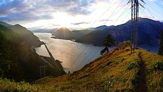
Cazadero Dam was a dam on the Clackamas River, near the city of Estacada, Oregon, United States. Construction began in 1904, and it was put into service in 1907.

Cazadero is an unincorporated historic locale in Clackamas County, Oregon, United States. Cazadero was a station on the Estacada interurban railway line of the Portland Railway, Light and Power Company (PRL&P) and later Portland Electric Power Company (PEPCO), near where the power plant of the PEPCO-owned Cazadero Dam was located on the Clackamas River.
The Mark O. Hatfield Memorial Trail is a proposed long-distance trail through the Columbia River Gorge in Multnomah County and Hood River County, Oregon. The trail will be approximately 60 miles, although the trail is still unofficial and its exact course is yet to be determined. The trail was first proposed by Tom Kloster on June 20, 2010, and suggests the Mark O. Hatfield Memorial Trail use existing trails from Multnomah Falls to Starvation Creek. Prior to this suggestion, the Talapus Trail, connecting the Pacific Crest Trail and Larch Mountain was slated for construction in 1974. Hikers openly used trails in the Bull Run Watershed into the 1980s, including the Talapus Trail.

The Mount Adams Recreation Area is a 21,000-acre (8,500 ha) recreation area in the U.S. state of Washington managed by the Yakama Nation Tribal Forestry Program. The area encompasses an ecologically complex and geologically active landscape. The region features the most rugged side of Mount Adams, including canyons and the Great Gap section of the Mount Adams circumnavigation route, a three-mile trail-less section over two great canyons and many difficult glacial creeks. At 12,276 feet (3,742 m), Mount Adams is one of the major Cascade mountains. The recreation area is on the east side of the mountain and is part of the Yakama Indian Reservation and includes the popular Bird Creek Meadows area.
The Willamette Escarpment is an escarpment that runs along the east bank of the Willamette River in Portland, Oregon, United States. The escarpment comprises two distinct sections: a 200-acre (81 ha) North Escarpment Unit, which extends from the Fremont Bridge northwest to the St. Johns Bridge, and a 75-acre (30 ha) South Escarpment Unit, which extends from the Sellwood Bridge north to the Ross Island Bridge.
References
- 1 2 "Parks and Nature System Plan" (PDF). Metro. Winter 2016. p. 109. Archived from the original (PDF) on December 24, 2016. Retrieved February 12, 2017.
The Cazadero Trail runs from Boring south to Barton. Someday, it could extend beyond Barton through Eagle Creek, Estacada and the Faraday, Cazadero and Promontory Park areas on up the Clackamas River corridor, eventually connecting to Mount Hood and the Pacific Crest Trail.
- ↑ "Cazadero Trail - Oregon". All Trails. Retrieved February 12, 2017.
Cazadero Trail is a 5.8 mile lightly trafficked out and back trail located near Boring, Oregon that features a river and is good for all skill levels. The trail offers a number of activity options and is best used from February until November. Dogs and horses are also able to use this trail.
- ↑ "Where to Walk: Deep Creek Canyon". Archived from the original on 2017-02-14. Retrieved 2017-02-13.