Related Research Articles

Cedar Point is a city in Chase County, Kansas, United States. As of the 2020 census, the population of the city was 22. It is about 5 miles east of Florence and 0.5 miles south of U.S. Route 50 highway.

Strong City is a city in Chase County, Kansas, United States. Originally known as Cottonwood Station, in 1881 it was renamed Strong City after William Barstow Strong, then vice-president and general manager, and later president of the Atchison, Topeka and Santa Fe Railway. As of the 2020 census, the population of the city was 386. It is located along U.S. Route 50 highway.
Lunice Creek is a 7.3-mile-long (11.7 km) tributary of the South Branch Potomac River, belonging to the Potomac River and Chesapeake Bay watersheds. The creek is located in Grant County, West Virginia. Lunice Creek is created by its North and South Forks and empties into the South Branch at Petersburg.
Lost Creek can refer to several places:
Kettle Creek is a 7.3-mile-long (11.7 km) tributary stream of the South Fork South Branch Potomac River in Hardy and Pendleton counties in West Virginia's Eastern Panhandle. Kettle Creek rises on Mitchell Knob and flows north along the eastern flanks of Sweedlin Hill through Sweedlin Valley in the George Washington National Forest.
Mill Creek is a 5.3-mile-long (8.5 km) tributary stream of the North Fork South Branch Potomac River in Pendleton County, West Virginia. Mill Creek rises on the western flanks of North Fork Mountain and from there, flows north through Germany Valley. Its confluence with the North Fork lies at Hinkle Gap between Germany and Harman Knobs.

Paint Branch is a 17.0-mile-long (27.4 km) tributary stream of the Anacostia River that flows Southeastwards through Montgomery County and Prince George's County, Maryland. Specifically, its primary tributary is of the Northeast Branch, which flows to the Anacostia River, Potomac River and the Chesapeake Bay. The beginning elevation of the stream is 480 feet above sea level and it subsequently drops to 30 feet when its flows meet the Indian Creek in College Park, Maryland.

Diamond Creek Township is a township in Chase County, Kansas, United States. As of the 2000 census, its population was 237.
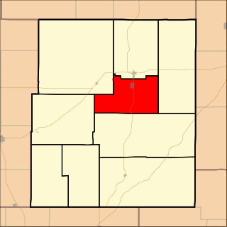
Falls Township is a township in Chase County, Kansas, United States. As of the 2000 census, its population was 1,163.

Black Creek is a tributary of the St. Johns River in Clay County, Florida. It is formed by the confluence of North Fork Black Creek and South Fork Black Creek. North Fork Black Creek originates as an outflow from Kingsley Lake and flows north and then southeast, meeting South Fork Black Creek on the east side of MIddleburg. North Fork Black Creek has Yellow Water Creek as its main tributary. South Fork Black Creek originates in a chain of lakes about four miles south of Kingsley Lake, with Ates Creek, Bull Creek, and Greens Creek as its main tributaries. Both forks are fed by areas of wetlands and numerous small streams.

The Clearwater River is in the northwestern United States, in north central Idaho. Its length is 74.8 miles (120.4 km), it flows westward from the Bitterroot Mountains along the Idaho-Montana border, and joins the Snake River at Lewiston. In October 1805, the Lewis and Clark Expedition descended the Clearwater River in dugout canoes, putting in at "Canoe Camp," five miles (8 km) downstream from Orofino; they reached the Columbia Bar and the Pacific Ocean about six weeks later.
Broad Run is a 38.0-mile-long (61.2 km) tributary of the Occoquan River in the U.S. state of Virginia. It rises in Fauquier County and passes through Thoroughfare Gap. A gazetteer from the mid-nineteenth century described it as a small stream, a valuable mill stream.
Cottonwood River is one of the principal tributaries of the Neosho River in central Kansas of the United States.

Cottonwood Creek is a major stream and tributary of the Sacramento River in Northern California. About 68 miles (109 km) long measured to its uppermost tributaries, the creek drains a large rural area bounded by the crest of the Coast Ranges, traversing the northwestern Sacramento Valley before emptying into the Sacramento River near the town of Cottonwood. It defines the boundary of Shasta and Tehama counties for its entire length. Because Cottonwood Creek is the largest undammed tributary of the Sacramento River, it is known for its Chinook salmon and steelhead runs.
Cedar Creek is a stream in Boone and Callaway counties of the U.S. state of Missouri. It is a tributary of the Missouri River. The headwaters of Cedar Creek are in northeast Boone County about five miles east of Hallsville and one mile west of the Audrain-Boone county line. The stream flows south and about five miles south of its headwaters the stream becomes the boundary between Boone and Callaway counties. The stream crosses under Interstate 70 about eight miles east of Columbia and enters the Mark Twain National Forest. The stream flows south to southwest through the national forest and upon leaving the forest turns to the east and ceases to be the county line. The stream flows east for about one mile then turns south and flows under U. S. Route 63 and into the Missouri River four miles northwest of Cedar City and across the river from Jefferson City. The Katy Trail crosses Cedar Creek just north of its confluence with the Missouri.
Coldwater Creek is a stream in Miami County, Kansas and Cass County, Missouri in the United States. It is a tributary of the South Fork of the South Grand River.
Cedar Fork is a stream in Franklin County in the U.S. state of Missouri. It is a tributary of Boeuf Creek.
Cole Creek is a stream in Callaway and Montgomery counties in the U.S. state of Missouri. It is a tributary of Prairie Fork of the Loutre River.
References
- ↑ U.S. Geological Survey Geographic Names Information System: Cedar Creek (Chase County, Kansas)
- ↑ Cedar Point, KS, 7.5 Minute Topographic Quadrangle, USGS, 1989
- 1 2 Cross, Frank B. (1954). "Fishes of Cedar Creek and the South Fork of the Cottonwood River, Chase County, Kansas". Transactions of the Kansas Academy of Science. 57 (3): 303–314. doi:10.2307/3626057. JSTOR 3626057.
38°15′39″N96°47′35″W / 38.26083°N 96.79306°W
| | This article about a location in Chase County, Kansas is a stub. You can help Wikipedia by expanding it. |