Cedar Lake East Beach

Last updated
Cedar Lake East Beach
Hidden-Beach-Packed.jpg
Many people at Cedar Lake Beach, then known as Hidden Beach, in July 2007.
Cedar Lake East Beach
TypeSwimming beach
Location Minneapolis, Minnesota, United States
Operated by Minneapolis Park and Recreation Board
OpenDaily, 6:00 a.m. to 10:00 p.m.
DesignationLife guards on duty seasonally
Website Cedar Lake East Beach

Cedar Lake East Beach is an urban beach in Minneapolis, Minnesota, United States. It is managed by the Minneapolis Park and Recreation Board and located on the east side of Cedar Lake. Formerly known as Hidden Beach, the area used to be obscured down a forested path, which contributed to its rise of prominence in the 1960s and 1970s as enclave of counter-culture. [1] After receiving attention for several decades due to illicit activities and safety concerns, the beach underwent a contentious "family-friendly" shift following efforts by the park board in the late 2010s. The location was already deemed extremely family friendly, patrons often brought their small children and infants to experience a community without judgement and to meet people from all walks of life. Unfortunately, the neighboring residents were not so welcoming of the "all walks of life" aspect of the community that had grown at Hidden Beach. [2]

Contents

History

Railway: 1860s to 1980s

Before 1867, Cedar Lake had a much different shape, and most of the woods surrounding Cedar Lake East Beach, particularly to the south east, were areas of water and wetland. In 1867, the St. Paul and Pacific Railway (a precursor to the BNSF Railway) built an earthen causeway through what was then a large bay on the east side of Cedar Lake. In 1871, the Minneapolis and St. Louis Railroad joined the St. Paul and Pacific Railway, running parallel tracks along the causeway. Slowly, by dumping cinders and other material, the part of the bay east of the causeway was filled in. The Minneapolis and St. Louis Railroad (became the St. Paul, Minneapolis, and Manitoba and moved its tracks from the east side to the north side of the lake 1883) then used the new land to create a major train yard. In 1878, a large scale ice cutting operation known as Cedar Lake Ice Company was founded on the lake's north eastern shore, which shipped ice to places as far away as St. Louis, Missouri. By 1900, Dingley's boat house occupied the end of a thin peninsula on the eastern side of the lake, which eventually widened and became the site of Cedar Lake East Beach.[ citation needed ]

In 1913, as part of the effort to create the Chain of Lakes as well as the Grand Rounds Scenic Byway, Cedar Lake was lowered by 5 feet (1.5 m) to connect it with Lake of the Isles. As a result, what remained of the East Bay (west of the old earthen rail corridor) completely dried up. Despite the large railway operations going on nearby, the land surrounding Cedar Lake's eastern shore was sold to build houses, hotels, and other such structures between 1895 and 1975. Unlike today, houses occupied both sides of Upton Avenue South. In the 1950s, the area was used as a city dump. Much of the road construction debris from the interstate highway projects wound up as mounds of rubbish along the eastern shoreline of Cedar Lake. The area quickly overgrew with cottonwood trees, resulting in the forested hills to the southeast of the beach.[ citation needed ]

Counter-culture: 1960s to mid-late 2000s

Sometime in the 1960s, the beach came to prominence. At the time, the beach was only a small grassy clearing by the shore, led to by a deer path-sized trail. It became known locally as an unofficial nude beach. Most of the railway yard closed by the mid-1980s, and the tracks and buildings were removed. In 1988, residents in the surrounding neighborhood purchased the land to the west of Upton Avenue South, between the lake and the road, and turned it into a city park with a vision of establishing a nature park. Instead, what established was a thriving community of local Minneapolis residents: many eclectic and artistic individuals of all races, who built a strong culture and welcoming group for daytime visitors that almost felt like a commune. While people did not live on site, many would spend the entire day or arrive after getting off work to join their community in beach games (some local to the area, like the legendary sport "Rock Golf" created by a longstanding elder member of the community), relaxation, music, shared food and drink, and the general attitude that all people from all ages and all walks of life were welcome and would be treated as family. The intergenerational aspect of the community was unique and something to be preserved, teens and seventy year old "old timers" who had been patrons of the area since the 60's and 70's were often found engaged in deep conversation or on the same teams for beach games and cards. Unfortunately, the polar opposite of the word "preservation" played out in every aspect imaginable - from destroying and removing the culture, to police brutalizing beachgoers who had committed minor offenses or often no crime at all, and decimating the natural beauty and endangered/threatened wildlife that once flourished there. The park police's continued harassment and abuse, the nearby wealthy neighborhood citizens dislike for counterculture and people who were "different", all this led to the downfall of the once beautiful place that used to be lovingly named Hidden Beach. [ citation needed ]

Park conversion: post 2010

In 1995, residents in the neighborhood surrounding the beach used money from the Neighborhood Revitalization Plan funds to hire off-duty police officers to patrol the beach more frequently. This was done officially through the Kenwood Isles Area Association. The reasons behind this stemmed from a concern over illegal activity at the beach. Residents claimed that they were concerned with their safety and wanted to crack down on nudity, marijuana use, parties, and the daytime commune-vibe. Some believed that a lack of an official entrance to the beach represented a major obstacle for the park police to patrol and gain access freely. Some patrons of the beach claimed that the wealthy residents in the surrounding neighborhood wanted to reduce or eliminate use by non-residents. The police reported that crime was not any higher at the beach than it was at many other official beaches in Minneapolis. The Kenwood Isles Area Association pushed the Minneapolis Park and Recreation Board for a solution. Yet, others used another excuse, claiming the pervasiveness of an invasive species of Buckthorn which had grown over large areas of the park. In 2004, the park board decided to "renovate" the park due to both the safety and ecologic concerns. That summer, the park board widened paths and clear cut areas leading to the beach by clearing out buckthorn; as well as all non-invasive trees, species, and endangered plant life. The park board removed additional vegetation in subsequent years and continues to do so. The vegetation obscured the view of the beach from the street, which made it considerably more difficult for park police members looking for a means of promotion by meeting their quotas - by handing out tickets for dog related offenses, occasional partial female nudity, and beer drinkers. Police brutality was a common occurrence in the 2000s. Crime in the local residential area was often mistakenly attributed to the beachgoers, who also suffered from car break-ins or robberies after leaving the beach and entering the residential area where cars could be parked, instead of the city bus lines that began in the poorest areas of town and ended in this upscale wealthy neighborhood. Violent crime and theft were not known to occur on the beach itself or amongst its patrons. [ citation needed ]

In 2007, community members held a session of meetings to address the growing concern over activity at the beach. Neighbors voted down a proposal to build a large parking lot. However, they voted in favor of graveling the path to the beach, which required clear cutting of additional trees and endangered plant life, to allow for service and police vehicles to reach the beach area. Other renovations approved included installation of picnic tables, a grill, a permanent police-only parking lot on the beachside itself, and a lifeguard stand. The initial wood life guard stand burned down, which some suspect was deliberate by vandals, and was replaced with a metal stand.[ citation needed ]

The cover for the 1985 album New Day Rising by Hüsker Dü was shot at Hidden Beach. [3]

See also

Related Research Articles

<span class="mw-page-title-main">Playa del Rey, Los Angeles</span> Neighborhood of Los Angeles in California, United States

Playa del Rey is a seaside suburb in the Santa Monica Bay and the South Bay region of Los Angeles County, California. It has a ZIP code of 90293 and area codes of 310 and 424. As of 2018, the community had a population of 16,230 people.

<span class="mw-page-title-main">Lake Nokomis</span> Lake in the state of Minnesota, United States

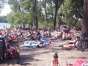
Lake Nokomis is one of several lakes in Minneapolis, Minnesota, and part of the city's Chain of Lakes. The lake was previously named Lake Amelia in honor of Captain George Gooding's daughter, Amelia, in 1819. Its current name was adopted in 1910 to honor Nokomis, grandmother of Hiawatha. It is located in the southern part of the city, west of the Mississippi River and south of Lake Hiawatha. The lake is oval in shape, with a long axis running southwest to northeast. Two pathways circle the lake, a 2.7-mile (4.3 km) pedestrian trail and a 2.8-mile (4.5 km) bicycle trail. Because the lower part of the lake is crossed by Cedar Avenue running north–south, the impression from the ground is that the lake is shaped like an L. The lake has an area of 204 acres (0.83 km2).

<span class="mw-page-title-main">Uptown, Minneapolis</span> Commercial District in Minnesota, United States

Uptown is a commercial district in southwestern Minneapolis in the U.S. state of Minnesota, that is centered at the intersection of Hennepin Avenue and West Lake Street. It has traditionally spanned the corners of four neighborhoods, Lowry Hill East, East Bde Maka Ska, South Uptown and East Isles neighborhoods, which are all within the Calhoun Isles community. Historically, the boundaries of Uptown are Bde Maka Ska to the west, Dupont Avenue to the east, 31st Street to the south, and 28th Street to the north; though these borders often vary. Uptown is a popular destination for retail, nightlife, and cultural events, and the district was famously written about by recording artist Prince.

<span class="mw-page-title-main">Neighborhoods of Minneapolis</span> Official communities and neighborhood of Minneapolis

The U.S. city of Minneapolis is officially defined by the Minneapolis City Council as divided into eleven communities, each containing multiple official neighborhoods. Informally, there are city areas with colloquial labels. Residents may also group themselves by their city street suffixes, North, Northeast, South, Southeast, and Southwest.

<span class="mw-page-title-main">Powderhorn Park, Minneapolis</span> Neighborhood in Hennepin, Minnesota, United States

The Powderhorn Park neighborhood of Minneapolis, Minnesota, United States is located approximately three miles south of downtown and is bordered by East Lake Street to the north, Cedar Avenue to the east, East 38th Street to the south, and Chicago Avenue to the west. Its namesake is the city's Powderhorn Park facility in the northwestern part of the neighborhood around Powderhorn Lake, which contains playing fields, playgrounds and a park building that hosts community education classes ranging from pottery to yoga. In winter, the Minneapolis Park and Recreation Board sets up a portable warming house and the lake is used for ice skating.

<span class="mw-page-title-main">Cedar-Riverside, Minneapolis</span> Neighborhood in Hennepin, Minnesota, United States

Cedar-Riverside, also referred to as the West Bank, or simply Riverside, is a neighborhood within Minneapolis, Minnesota. Its boundaries are the Mississippi River to the north and east, Interstate 94 to the south, and Hiawatha Avenue and Interstate 35W to the west. It has a longstanding tradition of cultural diversity and settlement, with a robust arts tradition.

<span class="mw-page-title-main">Cedar Lake (Minneapolis)</span> Lake in the state of Minnesota, United States

Cedar Lake is a lake in Minneapolis, Minnesota, United States, and part of the city's Chain of Lakes. It is located on the west side of the city, north of Bde Maka Ska and west of Lake of the Isles. The lake is surrounded by parkland, with some easements having been made to private homeowners on the southeast side; it is the only lake in the city with private shoreline. The south and west sides border the Cedar-Isles-Dean neighborhood, while the east shore flanks the Kenwood residential area. On the north is the Cedar Lake Trail and the BNSF Railway, and the south Bryn Mawr neighborhood. Cedar Lake has an area of 169 acres (0.68 km2) and a maximum depth of 51 feet (16 m). The Minneapolis Park and Recreation Board manages the lake and parkland around the lake.

<span class="mw-page-title-main">Cedar Lake Trail</span> Shared-use path in Minneapolis

Cedar Lake Trail is a 4.3-mile (6.9 km), shared-use path in the U.S. state of Minnesota, from downtown Minneapolis to the neighboring suburb of St. Louis Park. The trail begins at its eastern trailhead in downtown Minneapolis (44°59′11″N93°16′01″W) and continues west to Minnesota State Highway 100 in St. Louis Park (44°57′43″N93°20′36″W). At the trail's west end, a paved path continues for another 4.2 miles (6.8 km) through St. Louis Park to Hopkins under the former name of Hutchinson Spur Trail, but known as North Cedar Lake Regional Trail since 2009. In 2019, large portions of the Cedar Lake Trail were closed due to construction of the Southwest LRT extension with expected reopening in 2021 or 2022.

<span class="mw-page-title-main">Bancroft, Minneapolis</span> Neighborhood of Minneapolis

Bancroft is a neighborhood within the Powderhorn community in Minneapolis, Minnesota, United States. Its boundaries are East 38th Street to the north, Chicago Avenue to the west, East 42nd Street to the south and Cedar Avenue to the east.

<span class="mw-page-title-main">Three Rivers Park District</span> Park district in the Twin Cities

Three Rivers Park District is a special park district serving the suburban areas of the Twin Cities including suburban Hennepin, Carver, Dakota, Scott, and Ramsey counties. Three Rivers's mission is "To promote environmental stewardship through recreation and education in a natural resources-based park system." Three Rivers operates twenty parks and ten regional trails, with at least two more regional trails planned. Nearly seven million people visit Three Rivers facilities each year. It has over 27,000 acres (11,000 ha) of parks and trails.

<span class="mw-page-title-main">Neighborhoods of Jacksonville</span>

There are more than 500 neighborhoods within the area of Jacksonville, Florida, the largest city in the contiguous United States by area. These include Downtown Jacksonville and surrounding neighborhoods. Additionally, greater Jacksonville is traditionally divided into several major sections with amorphous boundaries: Northside, Westside, Southside, and Arlington, as well as the Jacksonville Beaches.

<span class="mw-page-title-main">Longfellow, Minneapolis</span> Community of Minneapolis

Longfellow is a defined community in Minneapolis, Minnesota which includes five smaller neighborhoods inside of it: Seward, Cooper, Hiawatha, Howe and Longfellow. The community is a mix of agri-industrial properties along the old Northern Pacific Railway, expansive parkland surrounding the famous Minnehaha Falls, and smaller residential areas.

<span class="mw-page-title-main">Bryn Mawr, Minneapolis</span> Neighborhood in Hennepin, Minnesota, United States

Bryn Mawr is a neighborhood within the Calhoun-Isles community in Minneapolis located directly west of downtown Minneapolis. Prior to the 1960s, the neighborhood was home to many workers of the nearby Minneapolis and St. Louis Railway yard. The neighborhood is all residential with two small business clusters, and a majority of it is surrounded by parks and hiking trails. The west-northwest border is adjacent to Theodore Wirth Park, while the southwestern perimeter borders Saint Louis Park.

<span class="mw-page-title-main">Bohemian Flats</span> City park in Minneapolis

Bohemian Flats Park is a park in Minneapolis, Minnesota, United States on the west bank of the Mississippi River near the Washington Avenue Bridge and next to the University of Minnesota campus. The area, once known as Little Bohemia, was the site of a shanty town as Minneapolis was incorporated in 1867. European immigrants seeking employment in the city or at the mills at the nearby St. Anthony Falls settled there. The former housing structures and historic buildings no longer remain. The park is managed by the Minneapolis Park and Recreation Board as part of the Mississippi Gorge Regional Park, and it lies within the Mississippi National River Recreation Area.

<span class="mw-page-title-main">Nokomis East</span> Group of neighborhoods in Minneapolis, Minnesota, United States

Nokomis East is a group of neighborhoods in the southeastern corner of Minneapolis, Minnesota, United States. It consists of four neighborhoods: Keewaydin, Minnehaha, Morris Park and Wenonah. Nokomis East contains two schools, the Nokomis Community Library, and a post office. On its western edge is Lake Nokomis, for which it is named. Two regional parks, and three neighborhood parks, provide recreation and educational programming for all age groups. Seven churches serve residents of various denominations. Nokomis East is served by the Nokomis East Neighborhood Association (NENA). The main transportation corridors are the neighborhood boundaries: Cedar Avenue, 34th and 28th Avenues, 50th and 54th Streets, Hwy 55, and Crosstown highway 62.

<span class="mw-page-title-main">Minneapolis Park and Recreation Board</span> Local governing body

The Minneapolis Park and Recreation Board (MPRB) is an independent park district that owns, maintains, and programs activities in public parks in Minneapolis, Minnesota, United States. It has 500 full-time and 1,300 part-time employees and an $111 million operating and capital budget.

<span class="mw-page-title-main">Winchell Trail</span> Hiking area in Minneapolis

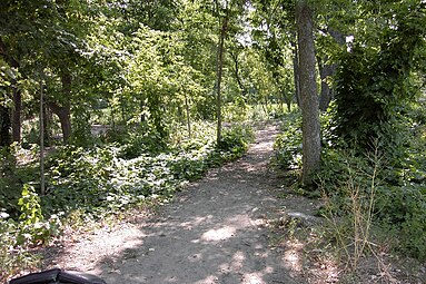
Winchell Trail is a five-mile (8 km) round trip, pedestrian-only trail in Minneapolis, Minnesota, United States, that runs along the west side of the Mississippi River between Franklin Avenue South and East 44th Street. Popular with bird watchers and naturalists, the rustic trail provides Upper Mississippi River gorge access and views. The trail is separate from the adjacent multi-use bicycle path, taking hikers past sandy beaches, an oak savanna restoration project, and the floodplain forest. The trail has multiple access points and the section from East 38th Street to East 44th Street is paved. Described as moderate and for all hiking skill levels, the out-and-back Winchell Trail has total elevation gain of 501 feet (153 m). Portions of the trail can be hiked in near solitude as its age and general destitute make it a widely forgotten place to explore.

<span class="mw-page-title-main">Samatar Crossing</span> Shared-use path in Minneapolis

Samatar Crossing is a 1,850-foot (560 m), shared-use path and innovative urban redesign project in Minneapolis, Minnesota, United States. Posthumously named after Somali-American politician and activist Hussein Samatar, the crossing connects the Downtown East/Elliot Park and Cedar-Riverside neighborhoods via a former interstate highway ramp. The Samatar Crossing redevelopment project received national recognition when it opened in 2018.

<span class="mw-page-title-main">Little Earth</span> Residential area in Minneapolis

Little Earth is a residential housing area in Minneapolis, Minnesota, United States that is home to nearly 1,500 people, many of whom are American Indian. The residential housing association at Little Earth considers itself a united people of 39 different American Indian tribes, but the area is not an urban reservation, a common mischaracterization. Little Earth is located in the Phillips community of Minneapolis. While being a notable district, it is not one of the officially designated neighborhoods in the city.

<span class="mw-page-title-main">Mississippi Gorge Regional Park</span> Urban park in Minnesota, United States

Mississippi Gorge Regional Park is a regional park along the east and west bluffs of the Mississippi River in the cities of Minneapolis and Saint Paul in the U.S. state of Minnesota. The two-city park area is between Mississippi river miles 848 and 852, from just south of Northern Pacific Bridge Number 9 to just north of Minnehaha Regional Park, and lies within the Mississippi National River and Recreation Area. The park area protects scenic and natural areas of the Mississippi River gorge, the only true gorge along the entire length of the 2,320-mile (3,730 km) river.

References

  1. Snyders, Matt (June 25, 2008). "The Legend of Hidden Beach". City Pages. Archived from the original on 2015-06-25.
  2. Zamora, Karen (June 19, 2018). "Choppy waters at Cedar Lake's Hidden Beach". Star Tribune. Archived from the original on 2018-06-20.
  3. Matos, Michaelangelo (2017-09-25). "Review: Hüsker Dü, 'Savage Young Dü'". North Country Public Radio . Canton, New York . Retrieved 2020-11-18.

4. Elizabeth Crandall, Primary Source Reference Material