
The Fox–Wisconsin Waterway is a waterway formed by the Fox and Wisconsin Rivers. First used by European settlers in 1673 during the expedition of Marquette & Joliet, it was one of the principal routes used by travelers between the Great Lakes and the Mississippi River until the completion of the Illinois and Michigan Canal in 1848 and the arrival of railroads. The western terminus of the Fox–Wisconsin Waterway was at the Mississippi at Prairie du Chien, Wisconsin. It continued up the Wisconsin River about 116 miles (187 km) until reaching Portage, Wisconsin. There travelers would portage to the Upper Fox River, or eventually, use the Portage Canal. It continued about 160 miles (260 km) down the Fox River, following it through Lake Winnebago and continuing on the Lower Fox over 170 feet of falls to the eastern terminus of Green Bay.

Going-to-the-Sun Road is a scenic mountain road in the Rocky Mountains of the western United States, in Glacier National Park in Montana. The Sun Road, as it is sometimes abbreviated in National Park Service documents, is the only road that traverses the park, crossing the Continental Divide through Logan Pass at an elevation of 6,646 feet (2,026 m), which is the highest point on the road. Construction began in 1921 and was completed in 1932 with formal dedication in the following summer on July 15, 1933. Prior to the construction of the road, visitors would need to spend several days traveling through the central part of the park, an area which can now be traversed within a few hours, excluding any stops for sightseeing or construction.
The Birmingham District is a geological area in the vicinity of Birmingham, Alabama, where the raw materials for making steel, limestone, iron ore, and coal are found together in abundance. The district includes Red Mountain, Jones Valley, and the Warrior and Cahaba coal fields in Central Alabama.

The Blackstone Canal was a waterway linking Worcester, Massachusetts, to Providence, Rhode Island through the Blackstone Valley via a series of locks and canals during the early 19th century. Construction was started in 1825, and the canal opened three years later. Following the opening of the Boston and Providence Railroad in 1835, the canal struggled for business. It was ultimately replaced by the Providence and Worcester Railroad, which completed a parallel line using much of the canal right-of-way in 1847, the canal shut down in 1848. Several segments of the canal are preserved.

Lock and Dam No. 4 is a lock and dam located near Alma, Wisconsin and Kellogg, Minnesota on the Upper Mississippi River around river mile 752.8. The lock and dam are owned and operated by the St. Paul District of the United States Army Corps of Engineers-Mississippi Valley Division.

Lock and Dam No. 6 is a lock and dam located near Trempealeau, Wisconsin on the Upper Mississippi River near river mile 714.1. It was constructed and placed in operation in June 1936. The last major rehabilitation was from 1989 to 1999. The dam consists of 893 feet (272.2 m) long concrete structure with five roller gates and 10 tainter gates. Its earth embankment is 2,600 feet (792.5 m)long and the concrete overflow spillway is 1,000 feet (304.8 m) long. The lock is 110 feet (33.5 m) wide by 600 feet (182.9 m) long. The lock and dam are owned and operated by the St. Paul District of the United States Army Corps of Engineers-Mississippi Valley Division.
Lock and Dam No. 8 is a lock and dam located near Genoa, Wisconsin on the Upper Mississippi River near river mile 679.2 in the United States. It was constructed and was put into operation by April 1937. The site then underwent major rehabilitation from 1989 through 2003. The lock and dam are owned and operated by the St. Paul District of the United States Army Corps of Engineers-Mississippi Valley Division.

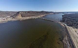
Lock and Dam No. 9 is a lock and dam located near Lynxville, Wisconsin and Harpers Ferry, Iowa on the Upper Mississippi River around river mile 647.9. The lower portion of Pool 9 was formally named Lake Winneshiek. The normal pool elevation behind the dam is 620 feet (189.0 m). It was constructed and placed in operation in July 1937. The site underwent a major rehabilitation from 1989 and 2006. The dam consists of concrete structure 811 feet (247.2 m) long with five roller gates and eight tainter gates. Earth embankment 9,800 feet (2,987.0 m) long with a grouted overflow spillway 1,350 feet (411.5 m) long. The lock is 110 feet (33.5 m) wide by 600 feet (182.9 m) long. Lock and Dam No. 9 is located 12 miles upstream from Prairie du Chien, Wisconsin. The lock and dam are owned and operated by the St. Paul District of the United States Army Corps of Engineers-Mississippi Valley Division.

General Zebulon Pike Lock and Dam No. 11 is a lock and dam located between Dubuque, Iowa, and rural Grant County, Wisconsin, on the Upper Mississippi River.

Lock and Dam No. 14 is a lock and dam located near LeClaire, Iowa on the Upper Mississippi River above Davenport, Iowa and Moline, Illinois. The movable portion of the dam is 1,343 feet (409.3 m) long and consists of 13 tainter gates and 4 roller gates. Connected to it is a 1,127 feet (343.5 m) long non-submersible rock fill dike which extends to the Illinois side. The main lock is 110 feet (33.5 m) wide by 600 feet (182.9 m) long. The site on the National Register of Historic Places as the Lock and Dam No. 14 Historic District (#04000174) listed in 2004 consisting of 3,043 acres (12.3 km2), 1 building, 6 structures, and 2 objects. It was completed in two phases, the first as part of the six foot channel project from 1921 to 1924, which included a lock and canal bypassing a hazardous rapids. The second phase was part of the nine foot channel project from 1935 to 1939 and included the main dam and the current main lock.

Lock and Dam No. 20 is a lock and dam located on the Upper Mississippi River, the lock side in Canton, Missouri and the dam crossing to Meyer, Illinois.

Lock and Dam No. 24 is a lock and dam located near Clarksville, Missouri around river mile 273.4 on the Upper Mississippi River. The main lock is 110 feet (33.5 m) wide and 600 feet (182.9 m) long with its bottom at an elevation of 430 feet. The auxiliary lock is not operational. Normal pool elevation behind the dam is 449 feet. The movable portion of the dam is 1,340 feet (408.4 m) long and consists of 15 submersible, elliptical, tainter gates. A 2,720 feet (829.1 m) submersible earthen dike extends from the movable dam to the Illinois shore. In 2004, the facility was listed in the National Register of Historic Places as Lock and Dam No. 24 Historic District, #04000183 covering 1,027 acres (4.2 km2), 3 buildings, 15 structures, 4 objects.

The Lowell Power Canal System is the largest power canal system in the United States, at 5.6 miles in length. It is operating through six major canals on two levels, controlled by numerous gates. The system was begun in the 1790s, beginning its life as a transportation canal called the Pawtucket Canal, which was constructed to get logs from New Hampshire down the Merrimack River to shipbuilding centers at Newburyport, Massachusetts, bypassing the 30-plus-foot drop of the Pawtucket Falls.

Morris Dam is a concrete gravity dam across the San Gabriel River in the U.S. state of California. It impounds Morris Reservoir, directly downstream of San Gabriel Dam.
Appleton Lock 4 Historic District is a historic district containing a 1907-built waterway lock in Appleton, Wisconsin. It was added to the National Register of Historic Places in 1993 for its significance in engineering and transport.

Appleton Locks 1–3 Historic District is a historic district partly in the city of Appleton, Wisconsin. It was added to the National Register of Historic Places for its significance in transport and engineering.

The Kaukauna Locks Historic District is a lock and dam system in Kaukauna, Wisconsin, United States, that carried boat traffic around a rapids of the Fox River starting in the 1850s as part of the Fox–Wisconsin Waterway. It was added to the National Register of Historic Places in 1993 for its significance in engineering and transport.

The Northwestern Branch, National Home for Disabled Volunteer Soldiers Historic District is a veterans' hospital located in Milwaukee, Wisconsin, with roots going back to the Civil War. Contributing buildings in the district were constructed from 1867 to 1955, and the 90 acres (36 ha) historic district of the Milwaukee Soldiers Home campus lies within the 400 acres (160 ha) Clement J. Zablocki VA Medical Center grounds, just west of American Family Field.

The De Pere Lock and Dam Historic District is located in De Pere, Wisconsin. It was added to the State Register of Historic Places in 1992 and to the National Register of Historic Places the following year.


