Central Brandenburg Plateaux and Lowlands

Last updated
Central Brandenburg Plateaux and Lowlands
Landscape near Golm Ehrenpfortenberg Golm.jpg
Landscape near Golm
Landscape near Golm
Native NameMittelbrandenburgische Platten und Niederungen
Area4,115.8 km²
Classification Handbook of Natural Region Divisions of Germany
Level 1 Region North German Plain
Level 2 Region Central North German Plain
Level 3 Region76–89 →
East German Plateaux and Heathland
Natural region 81
Central Brandenburg Plateaux and Lowlands
Highest point Wietkiekenberg (124.7 m)
State(s) Brandenburg, Saxony-Anhalt, Berlin
Country Germany

Coordinates: 52°18′30″N12°57′0″E / 52.30833°N 12.95000°E / 52.30833; 12.95000

Geographic coordinate system Coordinate system

A geographic coordinate system is a coordinate system that enables every location on Earth to be specified by a set of numbers, letters or symbols. The coordinates are often chosen such that one of the numbers represents a vertical position and two or three of the numbers represent a horizontal position; alternatively, a geographic position may be expressed in a combined three-dimensional Cartesian vector. A common choice of coordinates is latitude, longitude and elevation. To specify a location on a plane requires a map projection.

Contents

The Central Brandenburg Plateaux and Lowlands (German : Mittelbrandenburgische Platten und Niederungen) form a natural region in the German state of Brandenburg and in parts of southwest Berlin and the east of Saxony-Anhalt. They are major unit group 81 in the system of natural regions of Germany and part of the East German Plateaux and Heathlands. The Brandenburg portion of the Central Brandenburg Plateaux and Lowlands is largely coincident with the natural region designated as the Central March (Mittlere Mark) in the structural atlas of the state of Brandenburg. [1]

German language West Germanic language

German is a West Germanic language that is mainly spoken in Central Europe. It is the most widely spoken and official or co-official language in Germany, Austria, Switzerland, South Tyrol (Italy), the German-speaking Community of Belgium, and Liechtenstein. It is also one of the three official languages of Luxembourg and a co-official language in the Opole Voivodeship in Poland. The languages which are most similar to German are the other members of the West Germanic language branch: Afrikaans, Dutch, English, the Frisian languages, Low German/Low Saxon, Luxembourgish, and Yiddish. There are also strong similarities in vocabulary with Danish, Norwegian and Swedish, although those belong to the North Germanic group. German is the second most widely spoken Germanic language, after English.

Natural region region distinguished by its common natural features of geography, geology, and climate

A natural region is a basic geographic unit. Usually it is a region which is distinguished by its common natural features of geography, geology, and climate.

Brandenburg State in Germany

Brandenburg is a state of Germany.

Location

The Central Brandenburg Plateaux and Lowlands are part of the North German Plain. Neighbouring landscapes are the Luchland to the north, the East Brandenburg Heath and Lake District to the east, the Spreewald and the Lusatian Basin and Heathland to the southeast, the Fläming to the south and the Elbe Valley to the west.

Spreewald region in Brandenburg, Germany

The Spreewald is a section of the German state of Brandenburg located about 100 km south-east of Berlin. It was the center of the Battle of Halbe at the end of World War II, which included the last major land conflicts between German and Soviet forces. Spreewald was designated a biosphere reserve by UNESCO in 1991. It is known for its traditional irrigation system, consisting of more than 200 small canals within the 484-square-kilometre (187 sq mi) area. The landscape was shaped during the ice age. Alder forests on wetlands and pine forests on sandy dry areas are characteristic for the region. Grasslands and fields can be found as well.

Elbe Valley

The Elbe Valley is most often used as a term for that section of the river valley in which most of the quarters of Dresden are located. The Dresden Elbe Valley was declared a UNESCO World Heritage Site in 2005 and has lost the title June 25, 2009 due to a dispute between UNESCO and the City of Dresden. The city plans to construct bridge across the Elbe river, that will span it in the middle of the former World Heritage Site. In the opinion of UNESCO this construction will "deface" the historic site.

Description

Almost all the landscape elements that originated during the Weichselian Glaciation in the state of Brandenburg are united within the Central Brandenburg Plateaux and Lowlands. These are dominated by ground moraine plateaux of varying extent alternating with wide lowlands. Adjacent to the Nauen and Teltow ground moraine plateaux in the north are the lowlands of Havel, Nuthe and Notte. They are followed by the regions of the Karow Plateau, the Lehnin Land and the heaths of Beelitz and Luckenwald. In the far south a broad urstromtal , the Baruth Valley.

Nauen Plateau

The Nauen Plateau is a low plateau in the German states of Brandenburg and Berlin. It rises above the surrounding countryside by an average of 15 metres (49 ft) and is a largely contiguous upland area that was formed during the Saale and Weichselian glaciations. It consists predominantly of ground moraine deposits, partly overlain by gently rolling end moraine formations. Whilst the neighbouring regions of Zauche to the south, the Teltow to the southeast and the Barnim to the northeast have the same name as their geological formation, the cultural landscape on the Nauen Plateau bears the historical and regional name of Havelland. That said, the river country of the Havelland extends beyond the plateau to include the Havel valley and other lowland areas.

An urstromtal is a type of broad glacial valley, for example, in northern Central Europe, that appeared during the ice ages, or individual glacial periods of an ice age, at the edge of the Scandinavian ice sheet and was formed by meltwaters that flowed more or less parallel to the ice margin. Urstromtäler are an element of the glacial series. The term is German and means "ancient stream valley". Although often translated as "glacial valley", it should not be confused with a valley carved out by a glacier. More accurately some sources call them "meltwater valleys" or "ice-marginal valleys".

The highest points are found in the form of push moraines. The Wietkiekenberg reaches a height of 124.7 m, the Kleiner Ravensberg near Potsdam 114.2 m, the Götzer Berg 108.6 m. The entire natural region is drained by the Havel and its tributaries.

Push moraine

A push moraine or pushed moraine is in geomorphology a moraine that forms when the terminus advance of a lowland glacier pushes unstratified glacial sediment into a pile or linear ridge in front of it. A push moraine is identified by its ability to push sediment upwards from its original horizontal position. Push moraines are limited in size by the advance of a glacier front and its tendency to shear over the top of any ridge large enough to resist the movement of ice. Pushed moraines generally occur in low, flat plains at higher latitudes and were formed during the glacial stages of the Quaternary ice age. They can be up to 100 km long and several hundreds of metres in height.

Kleiner Ravensberg mountain

Kleiner Ravensberg is the highest elevation in the municipal area of Potsdam in Brandenburg, Germany with a peak at 114.2 m above sea level. It is located in a woodland called Ravensberge. The hill is part of a push moraine which was formed during the Weichselian glaciation.

Natural regions

The Central Brandenburg Plateaux and Lowlands are subdivided as follows:

Literature

Related Research Articles

Fläming Heath

The Fläming Heath is a region and a hill chain that reaches over 100 km from the Elbe river to the Dahme River in the German states Saxony-Anhalt and Brandenburg. Its highest elevation is the Hagelberg. The name Fläming originates from the 12th century, when Flemish colonists came to settle in the region from the overcrowded cities of Flanders.

Margraviate of Brandenburg major principality of the Holy Roman Empire from 1157 to 1806

The Margraviate of Brandenburg was a major principality of the Holy Roman Empire from 1157 to 1806 that played a pivotal role in the history of Germany and Central Europe.

Mecklenburg Lake Plateau largest coherent lake and canal region in Germany

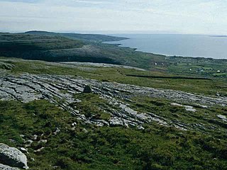
The Mecklenburg Lake Plateau or Mecklenburg Lakeland is the largest coherent lake and canal region in Germany and is sometimes called "the land of a thousand lakes". There are several nature parks and well-known lakes with unique flora and fauna in the region, such as the Müritz, the biggest German lake lying entirely within Germany, the Plauer See, the Fleesensee, the Tollensesee, the Schmaler Luzin and the Kölpinsee.

North German Plain plain in Germany

The North German Plain or Northern Lowland is one of the major geographical regions of Germany. It is the German part of the North European Plain. The region is bounded by the coasts of the North Sea and the Baltic Sea to the north and Germany's Central Uplands to the south.

Natural regions of Germany

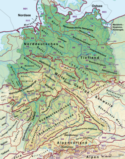
This division of Germany into major natural regions takes account primarily of geomorphological, geological, hydrological, and pedological criteria in order to divide the country into large, physical units with a common geographical basis. Political boundaries play no part in this, apart from defining the national border.

The Berlin/Brandenburg metropolitan region or capital region is one of eleven metropolitan regions of Germany, consisting of the entire territories of the city-state of Berlin and the surrounding state of Brandenburg. The region covers an area of 30,370 square kilometres (11,730 sq mi) with a total population of about 6 million.

Barnim Plateau plateau in Germany

The Barnim Plateau is a plateau which is occupied by the northeastern parts of Berlin and the surrounding federal state of Brandenburg in Germany.

Otto III, Margrave of Brandenburg Margrave of Brandenburg

Otto III, nicknamed the pious was Margrave of Brandenburg jointly with his elder brother John I until John died in 1266. Otto III then ruled alone, until his death, the following year.

Paplitz (Baruth/Mark) Stadtteil of Baruth/Mark in Brandenburg, Germany

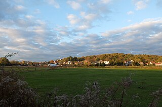
Paplitz is a village, part of the town of Baruth/Mark and a former municipality in the Teltow-Fläming district, in Brandenburg, Germany. It is situated in the Glogau-Baruther Urstromtal at the border of the Fläming Heath, 3 km west of Baruth and 53 km south of Berlin.

Eastern Upper Lusatia is a natural region in Saxony and, in a broader sense, part of the Western Sudetes range including the Lower Silesian Voivodeship. The current Saxon division of natural regions view the region as part of the Saxon Loess Fields and divides it into 12 subdivisions at the level of meso-geochores.

Saxon-Lower Lusatian Heathland

The Saxon-Lower Lusatian Heathland is a natural region in the German state of Saxony. The current natural region division of the Free State of Saxony groups landscape units of the upper geochore or sub-regional level into three "Saxon natural regions" to produce a large-scale classification. These are part of higher order (cross-border) natural regions, whereas the landscape units previously used described areas that were largely confined within the borders of Saxony.

Havelland Luch fen in Germany

The Havelland Luch is a lowland area inside a bend of the River Havel west of Berlin, and forms the heart of the Havelland region.

<i>Ländchen</i> (Havelland)

A Ländchen is the German name given to several Ice Age plateaux in the Havelland region, which climb to over 70 metres above the formerly marshy urstromtal levels of the Havelland Luch and the Rhinluch. The difference between these Ländchen and the surrounding countryside is even more marked because of the different land uses to which they are put. Extensive pastures in the lowlands contrast with the arable fields and woods on the low hills. Geologically they are largely complete formations of ground moraine from the Saale and Weichselian glaciations that, in places, are covered by gently rolling end moraines.

Havelland region in Brandenburg, Germany

Geographically the Havelland is the region, around which the River Havel flows in a U-shape between Oranienburg to the northeast and Rhinow to the northwest. The northern boundary of the Havelland is formed by the River Rhin and the Rhin Canal. In the history of Brandenburg, the Havelland represents a historic region.

Teltow (region) plateau and historical distinct landscape in Berlin and Brandenburg

Teltow [] is both a geological plateau and also a historical region in the German states of Brandenburg and Berlin. As an historical region, the Teltow was one of the eight territories out of which the March of Brandenburg was formed in the 12th and 13th centuries. As a result of the Teltow War (1239–1245) the question of territorial lordship of the newly created heart of the expanding march was finally decided here. Between 1835 and 1952 there was also a county, Teltow district; in addition a town immediately south of Berlin, in the present-day county of Potsdam-Mittelmark, bears the name Teltow.

North Brandenburg Plateaux and Upland

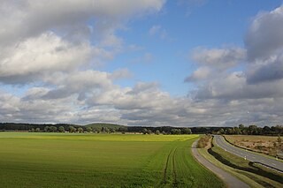
The North Brandenburg Plateaux and Upland is a natural region in the northwest of Brandenburg and, to a lesser extent, the southwest of Mecklenburg-Vorpommern and northeast of Saxony-Anhalt in Germany. It is major unit group no. 77 in the natural regional divisions of Germany. The Brandenburg portion of the North Brandenburg Plateaux and Upland is largely coextensive with the natural region of Prignitz and Ruppin Land in the structural atlas of the state of Brandenburg.

Neuendorf (Brück) Village in Potsdam-Mittelmark district, Germany

Neuendorf is a district of Brück in the Brandenburg district Potsdam-Mittelmark.

References

  1. "Naturräumliche Gliederung 2007" (pdf; 803 kB). Strukturatlas (in German). Brandenburgisches Landesamt für Bauen und Verkehr, Raumbeobachtung. Retrieved 2012-10-30.