Related Research Articles

Brooklyn is a borough of New York City, coextensive with Kings County, in the U.S. state of New York. Kings County is the most populous county in the State of New York, and the second-most densely populated county in the United States, behind New York County (Manhattan). Brooklyn is also New York City's most populous borough, with 2,736,074 residents in 2020. If each borough were ranked as a city, Brooklyn would rank as the third-most populous in the U.S., after Los Angeles and Chicago.

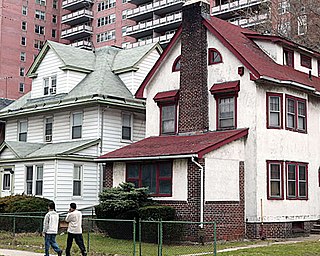
Crown Heights is a neighborhood in the central portion of the New York City borough of Brooklyn. Crown Heights is bounded by Washington Avenue to the west, Atlantic Avenue to the north, Ralph Avenue to the east, and Empire Boulevard/East New York Avenue to the south. It is about one mile (1.6 km) wide and two miles (3.2 km) long. Neighborhoods bordering Crown Heights include Prospect Heights to the west, Flatbush and Prospect Lefferts Gardens to the south, Brownsville to the east, and Bedford–Stuyvesant to the north.

Flatbush is a neighborhood in the New York City borough of Brooklyn. The neighborhood consists of several subsections in central Brooklyn and is generally bounded by Prospect Park to the north, East Flatbush to the east, Midwood to the south, and Kensington and Parkville to the west. The neighborhood had a population of 105,804 as of the 2010 United States Census. The modern neighborhood includes or borders several institutions of note, including Brooklyn College.
Kensington is a neighborhood in the central portion of the New York City borough of Brooklyn, located south of Prospect Park and Green-Wood Cemetery. It is bordered by Coney Island Avenue to the east; Fort Hamilton Parkway and Caton Avenue to the north; McDonald Avenue and 36th Street to the west; and Ditmas Avenue or Foster Avenue to the south. Kensington and Parkville are bordered by the Prospect Park South and Ditmas Park subsections of Flatbush to the east; Windsor Terrace to the north; Borough Park to the west; and Midwood to the south.

Prospect Heights is a neighborhood in the northwest of the New York City borough of Brooklyn. The traditional boundaries are Flatbush Avenue to the west, Atlantic Avenue to the north, Eastern Parkway – beginning at Grand Army Plaza – to the south, and Washington Avenue to the east. In the northern section of Prospect Heights are the Vanderbilt Rail Yards, built over as part of the Pacific Park project. The Barclays Center, home to the NBA's Brooklyn Nets basketball team, is located in the northwestern corner of the neighborhood in Pacific Park at Flatbush and Atlantic Avenues.

Flatbush Avenue is a major avenue in the New York City Borough of Brooklyn. It runs from the Manhattan Bridge south-southeastward to Jamaica Bay, where it joins the Marine Parkway–Gil Hodges Memorial Bridge, which connects Brooklyn to the Rockaway Peninsula in Queens. The north end was extended from Fulton Street to the Manhattan Bridge as "Flatbush Avenue Extension".

Atlantic Avenue is a major thoroughfare in the New York City boroughs of Brooklyn and Queens. It stretches from the Brooklyn waterfront on the East River all the way to Jamaica, Queens. Atlantic Avenue runs parallel to Fulton Street for much of its course through Brooklyn, where it serves as a border between the neighborhoods of Prospect Heights and Fort Greene and between Bedford-Stuyvesant and Crown Heights.

Bedford–Stuyvesant, colloquially known as Bed–Stuy, is a neighborhood in the northern section of the New York City borough of Brooklyn. Bedford–Stuyvesant is bordered by Flushing Avenue to the north, Classon Avenue to the west, Broadway to the east, and Atlantic Avenue to the south. The main shopping street, Fulton Street runs east–west the length of the neighborhood and intersects high-traffic north–south streets including Bedford Avenue, Nostrand Avenue, and Stuyvesant Avenue. Bedford–Stuyvesant contains four smaller neighborhoods: Bedford, Stuyvesant Heights, Ocean Hill, and Weeksville. Part of Clinton Hill was once considered part of Bedford–Stuyvesant.

Brownstone is a brown Triassic–Jurassic sandstone that was historically a popular building material. The term is also used in the United States and Canada to refer to a townhouse clad in this or any other aesthetically similar material.

Community boards of Brooklyn are New York City community boards in the borough of Brooklyn, which are the appointed advisory groups of the community districts that advise on land use and zoning, participate in the city budget process, and address service delivery in their district.

Ocean Hill is a subsection of Bedford-Stuyvesant in the New York City borough of Brooklyn. The neighborhood is part of Brooklyn Community Board 16 and was founded in 1890. The ZIP code for the neighborhood is 11233. Ocean Hill's boundaries start from Broadway and the neighborhood of Bushwick in the north, Ralph Avenue and the neighborhoods of Bedford-Stuyvesant proper and Crown Heights to the west, East New York Avenue and the neighborhood of Brownsville to the south, and Van Sinderen Avenue and the neighborhood of East New York to the east.
New York's 9th congressional district is a congressional district for the United States House of Representatives in New York City, represented by Yvette Clarke.
The demographics of Brooklyn reveal a very diverse borough of New York City and a melting pot for many cultures, like the city itself. Since 2010, the population of Brooklyn was estimated by the Census Bureau to have increased 3.5% to 2,592,149 as of 2013, representing 30.8% of New York City's population, 33.5% of Long Island's population, and 13.2% of New York State's population. If the boroughs of New York City were separate cities, Brooklyn would be the third largest city in the United States after Los Angeles and Chicago.

Prospect Lefferts Gardens is a residential neighborhood in the Flatbush area of the New York City borough of Brooklyn. The community is bounded by Empire Boulevard to the north, Clarkson Avenue to the south, New York Avenue to the east, and Ocean Avenue/Prospect Park to the west. Prospect Lefferts Gardens was designated a NYC Landmark area in 1979 and called the Prospect Lefferts Gardens Historic District.
Bedford Avenue is the longest street in Brooklyn, New York City, stretching 10.2 miles (16.4 km) and 132 blocks, from Manhattan Avenue in Greenpoint south to Emmons Avenue in Sheepshead Bay, and passing through the neighborhoods of Williamsburg, Bedford-Stuyvesant, Crown Heights, Flatbush, Midwood, Marine Park, and Sheepshead Bay.

Since its founding in 1625 by Dutch traders as New Amsterdam, New York City has been a major destination for immigrants of many nationalities who have formed ethnic enclaves, neighborhoods dominated by one ethnicity. Freed African American slaves also moved to New York City in the Great Migration and the later Second Great Migration and formed ethnic enclaves. These neighborhoods are set apart from the main city by differences such as food, goods for sale, or even language. Ethnic enclaves provide inhabitants security in work and social opportunities, but limit economic opportunities, do not encourage the development of English speaking, and keep immigrants in their own culture.
Each of New York City's five counties has its own criminal court system and District Attorney, the chief public prosecutor who is directly elected by popular vote. Charles J. Hynes, a Democrat, was the District Attorney of Kings County from 1990 to 2013. Brooklyn has 16 City Council members, the largest number of any of the five boroughs. The Brooklyn Borough Government includes a borough government president as well as a court, library, borough government board, head of borough government, deputy head of borough government and deputy borough government president.
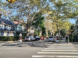
West Midwood is a planned community and historic enclave in the New York City borough of Brooklyn. West Midwood is located in central Brooklyn in the southern edge of the community of Victorian Flatbush, abutting the northern boundary of the community of Midwood. It is bordered by Foster Avenue to the north, the BMT Brighton subway line to the east, Avenue H to the south, and Coney Island Avenue to the west. West Midwood is located south of Prospect Park within what is sometimes referred to as Ditmas Park.

The Willink Entrance area, also known as Willink Plaza, is a major urban square of Brooklyn, New York City, formed by the intersection of Flatbush Avenue, Ocean Avenue and Empire Boulevard, at the eastern corner of Prospect Park and the southern corner of the Brooklyn Botanic Garden. It is serviced by the New York City Subway's Prospect Park station, and features several public spaces and historic buildings. This location is considered the northwestern point of the Prospect Lefferts Gardens neighborhood of Flatbush, and adjoins Crown Heights to its northeast.
References
- ↑ Ford Fessenden, Sam Roberts. "Then as Now — New York's Shifting Ethnic Mosaic". New York Times. Archived from the original on 2019-01-11. Retrieved June 23, 2020.
| | This New York City–related article is a stub. You can help Wikipedia by expanding it. |