Related Research Articles

Belize is a country on the north-eastern coast of Central America. It is bordered by Mexico to the north, the Caribbean Sea to the east, and Guatemala to the west and south. It also shares a water boundary with Honduras to the southeast.
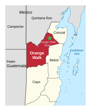
Orange Walk District is a district in the northwest of the nation of Belize, with its district capital in Orange Walk Town.

Cayo District is located in the west part of Belize, whose capital, Belmopan it contains. It is the most extensive, second-most populous and third-most densely populated of the six districts of Belize. The district's capital is the town of San Ignacio.

Hattieville is a village in the Belize District of the nation of Belize. It is located at 17N 88W, at an elevation of 196 feet above mean sea level, and has a population of about 1,300 people. Hattieville was established as a refugee camp after Hurricane Hattie made many people homeless in Belize City when it hit in 1961, but it became a permanent town.
Guinea Grass is a village in the Orange Walk District of the nation of Belize. It is 38 metres above sea level. According to the 2000 census, Guinea Grass had a population of 2,510 people; by 2010 the census figures showed a population of 3,500. The population is made up of mostly Mestizos, Creoles, and East Indians. There are a number of Mennonites, Taiwanese and other Central American immigrants living near or immediately in the village.
Roaring Creek is a small village in the Cayo District of Belize, just north-west of Belmopan. Its name is derived from the creek waterfalls which flow into the Belize River next to the Guanacaste Park area.

The Diplomatic Quarter is a building that houses most of Taiwan's foreign embassies, as well as the headquarters of the International Cooperation and Development Fund (TaiwanICDF). It is located in the Tianmu neighbourhood of Shilin District in the capital Taipei.
Arenal is a village in the Cayo District of central interior Belize. It is part of the Cayo West constituency. The village is in an agricultural region with the most frequent crops being citrus and banana. It is one of 192 municipalities administered at the village level in the country for census-taking purposes. The village had a population of 613 in 2010. This represents roughly 0.9% of the district's total population. This was a 29.1% increase from 475 people recorded in the 2000 census.
Billy White is a village in the Cayo District of central interior Belize, located on the north shore of the Belize River. The village is in an agricultural region with the most frequent crops being citrus and banana. It is one of 192 municipalities administered at the village level in the country for census taking purposes.
Branch Mouth is a village in the Cayo District of central interior Belize. It is situated north of San Ignacio and named for its placement near the confluence of the Macal and Mopan Rivers where the Belize River is formed. The village is in an agricultural region with the most frequent crops being citrus and banana. It is one of 192 municipalities administered at the village level in the country for census-taking purposes.
Buena Vista is a village in the Cayo District of central interior Belize. It is situated along the Mopan River near the border with Guatemala. The village is in an agricultural region with the most frequent crops being citrus and banana. It is one of 192 municipalities administered at the village level in the country for census taking purposes. The village had a population of 599 in 2010. This represents roughly 0.9% of the district's total population. This was a 95.8% increase from 306 people recorded in the 2000 census.
Calla Creek is a village in the Cayo District of central interior Belize. It is situated along the Mopan River near the border with Guatemala. The village is in an agricultural region with the most frequent crops being citrus and banana. It is one of 192 municipalities administered at the village level in the country for census taking purposes.

Cotton Tree is a village in the Cayo District of central interior Belize. The village is situated 5km to the northeast of Belmopan along the Western Highway. The surrounding area is agricultural with the most frequent crops being citrus and banana. It is one of 192 municipalities administered at the village level in the country for census taking purposes.
Cristo Rey is a village in the Cayo District of central interior Belize, situated on the east bank of the Macal River. The village is in an agricultural region with the most frequent crops being citrus and banana. It is one of 192 municipalities administered at the village level in the country for census taking purposes.
Duck Run I, or alternatively Duck Run 1, is a village in the Cayo District of central interior Belize. The village is in an agricultural region with the most frequent crops being citrus and banana. It is one of 192 municipalities administered at the village level in the country for census taking purposes. The village had a population of 663 in 2010. This represents roughly 1% of the district's total population. No census record was taken for the village in 2000. Duck Run I is one of three recognized municipalities with the name "Duck Run" south of Spanish Lookout having its own local government representation. The other two communities are Duck Run II and Duck Run III.
Duck Run II, alternatively known as Duck Run 2, is a village in the Cayo District of central interior Belize. The village is in an agricultural region with the most frequent crops being citrus and banana. It is one of 192 municipalities administered at the village level in the country for census taking purposes. The village had a population of 370 in 2010. This represents roughly 0.6% of the district's total population. No census record was taken for the village in 2000. Duck Run II is one of three recognized municipalities with the name "Duck Run" south of Spanish Lookout having its own local government representation. The other two communities are Duck Run I and Duck Run III.
Duck Run III, alternatively known as Duck Run 3, is a village in the Cayo District of central interior Belize.The village is in an agricultural region where the most common crops are citrus and banana. It is one of 192 village level municipalities for census purposes. The village had a population of 400 in 2010. This represents roughly 0.6% of the district's total population. No census record was taken for the village in 2000. Duck Run III is one of three recognized municipalities with the name "Duck Run" south of Spanish Lookout having its own local government. The other two communities are Duck Run I and Duck Run II.
Georgeville is a village in the Cayo District of central interior Belize. The village is in an agricultural region with the most frequent crops being citrus and banana. It is one of 192 municipalities administered at the village level in the country for census taking purposes. The village had a population of 922 in 2010. This represents roughly 1.4 % of the district's total population. This was a 60.9% increase from 573 people recorded in the 2000 census.

Unitedville is a village in the Cayo District of central interior Belize. The village is in an agricultural region with the most frequent crops being citrus and banana. It is one of 192 municipalities administered at the village level in the country for census taking purposes.
References
- ↑ "Census Data".
- ↑ "Administrative Division of Belize". www.geonames.org.
- ↑ "TaiwanICDF - Taiwan Technical Mission in Belize Plans to Expand the Scale of the Sheep Industry". www.icdf.org.tw.
17°11′09″N89°00′06″W / 17.18583°N 89.00167°W
| | This article about the geography of Belize is a stub. You can help Wikipedia by expanding it. |