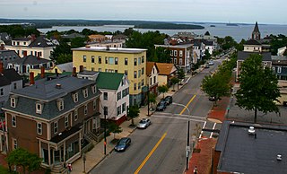
Munjoy Hill is both a neighborhood and prominent geographical feature of Portland, Maine. It is located east of downtown and south of East Deering, the neighborhood it is connected to by Tukey's Bridge. The neighborhood historically had a large Irish and Italian American population.

The great fire of Portland, Maine, sometimes known as the 1866 great fire of Portland, occurred on July 4, 1866—the second Independence Day after the end of the American Civil War. Five years before the Great Chicago Fire, this was the greatest fire yet seen in an American city. It started in a boat house on Commercial Street, likely caused by a firecracker or a cigar ash. The fire spread to a lumber yard and on to a sugar house, then spread across the city, eventually burning out on Munjoy Hill in the city's east end. Two people died in the fire and 10,000 people were made homeless. 1,800 buildings were burned to the ground. This included the federal Exchange Building by which was replaced with the custom house. Soon after the fire, Portland native and acclaimed poet Henry Wadsworth Longfellow described his old home town: "Desolation, desolation, desolation. It reminded me of Pompeii, that ‘sepult city."

Franklin Towers is a 16-story high-rise building located in Portland, Maine, at the corner of Franklin Street and Cumberland Avenue, rising to a height of 175 feet (53 m). Construction was completed in 1969, and its primary use is residential. It was listed on the National Register of Historic Places in 2024.
Kennedy Park is a neighborhood in East Bayside in downtown Portland, Maine, built around a park, athletic fields, basketball courts, a playground and the Boyd Street Urban Garden.
The Arts District is a section of downtown Portland, Maine’s designated in 1995 as to promote the cultural community and creative economy of the city. It covers a large part of upper Congress Street towards the West End and spans Congress Street toward the East ending at Portland City Hall and its Merrill Auditorium concert hall.

Stanley Thomas Pullen Fountain is an historic public water fountain and horse trough in Portland, Maine. It is named for Stanley T. Pullen, a former president of the Maine State Society for the Protection of Animals. Pullen died in 1910; the fountain's installation date is not known. The fountain was designed by George Burnham, and is made from granite mined at Jay, Maine.
Monument Square is a town square in downtown Portland, Maine, about halfway between the East Bayside and Old Port neighborhoods. The Time and Temperature Building, Fidelity Trust Building, and the main branch of the Portland Public Library are on Congress Street, across from the square, while One Monument Square and One City Center are among the buildings on the square itself.

The Baxter Building is an historic building located at 619 Congress Street in downtown Portland, Maine. Completed in 1888, it served as the Portland Public Library from its founding until 1978, when the Library moved to another location on Congress Street. The building went unused from 1978 to 1983, when it was purchased by the Maine College of Art (MECA). MECA utilized the space for studio space, dark rooms, as a computer lab and library. In 2010, MECA sold the building to Northland Enterprises LLC, which then leased it to the VIA Group.

Forest Avenue is a major street in Portland, Maine, United States. It runs for around 4.78 miles (7.69 km) from Bridgton Road in the northwest to Congress Street, in downtown Portland, in the southeast. It is the main artery for traffic entering and leaving Portland to and from the north via city streets. The street ends in Portland's Arts District.

The Fidelity Trust building is a historic office building in Monument Square, Portland, Maine.

The Press Herald Building is an historic building in Portland, Maine, built in 1923 and expanded in 1948. It is strategically located across Congress Street from Portland City Hall. It was occupied by the Portland Press Herald newspaper until 2010. In 2015, the renovated building reopened as the Press Hotel.
The South Portland Armory is an historic armory building in South Portland, Maine, United States. The structure was built in 1941 to support nearby U.S. war production for World War II, including the building of liberty ships. It was built in the Art Deco style and was used by the Maine National Guard until 1996. In 2012, it was listed on Greater Portland Landmarks' Places in Peril list.
The B&M Baked Beans factory is an historic cannery building in Portland, Maine, USA. Constructed in 1913 in the East Deering neighborhood, it was built by the Burnham & Morrill Company. Baked beans were produced in the building until 2021. The building is a prominent landmark highly visible from Interstate 295. It is located at 1 Beanpot Circle.
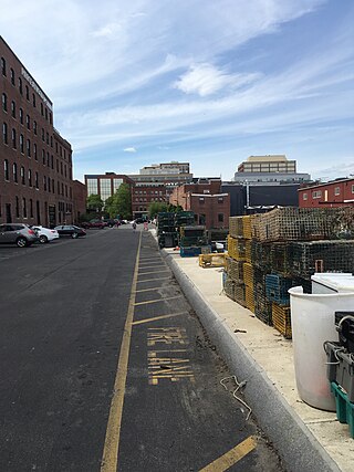
Merrill's Wharf is a historic wharf in Portland, Maine, on the edge of the Fore River. It stands across Commercial Street from Cross Street and, on the waterfront side, between Union Wharf and the Portland Fish Pier. It was formerly known as Dana's Wharf.

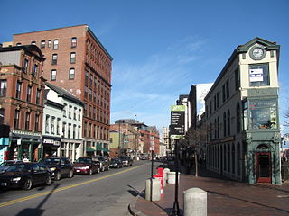
Fore Street is a downtown street in Portland, Maine, United States. It runs for around 1 mile (1.6 km), from the Eastern Promenade on Munjoy Hill in the northeast to Pleasant Street in the southwest. Near its midsection, Fore Street crosses Franklin Street. It splits briefly at Boothby Square, shortly after passing the United States Custom House. The street passes through the Old Port district.
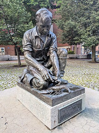
The Maine Lobsterman is a sculpture in Lobsterman Park, Portland, Maine, United States. Standing at the intersection of Middle Street and Temple Street, it was sculpted by Victor Kahill for the 1939 New York World's Fair and served as the centerpiece of the Maine exhibit in the Hall of States. Once it returned to Portland, it was displayed at the Columbia Hotel and the Portland City Hall before being placed at its present location on Temple Street in 1977. In 2021, the Portland Press Herald described it as one of the most iconic landmarks in the city. In July 2022, the animal rights non-profit People for the Ethical Treatment of Animals sent a letter to mayor Kate Snyder urging the city replace the sculpture with another sculpture showing a lobster crushing a trap.

Middle Street is a downtown street in Portland, Maine, United States. It runs for around 0.46 miles (0.74 km), from an intersection with Union Street, Spring Street and Temple Street in the southwest, to Hancock Street, at the foot of Munjoy Hill, in the northeast. It formerly originated at what was then known as Market Square, but 20th-century redevelopment saw the section between Monument Square and Free Street pedestrianized, and the remaining section—around The Maine Lobsterman monument—erased.

High Street is a downtown street in Portland, Maine, United States. It runs one-way for around 0.81 miles (1.30 km), from Commercial Street in the southeast to Forest Avenue in the northwest. It is one of the three main routes crossing the Portland peninsula in this direction, the other two being State Street and Franklin Street. Part of the street passes through the Spring Street Historic District and the city's Arts District.

India Street is a downtown street and neighborhood in Portland, Maine, United States. Situated near the western foot of Munjoy Hill, it runs for around 0.28 miles (0.45 km), from Congress Street in the northwest to Commercial Street and Thames Street in the southeast. It was the city's first street, and the location of the first settlement of European immigrants to the city in the 17th century. There are thirty handmade bricks in the sidewalk commemorating the neighborhood's notable events. In 1680, when Thomas Danforth was Deputy Governor of the Massachusetts Bay Colony, the street was known as Broad Street. After the incorporation of the Town of Falmouth in 1718, the street was known as High King Street.

Federal Street is a historic downtown street in Portland, Maine, United States. It runs for around 0.56 miles (0.90 km), from Monument Square in the southwest to Mountfort Street, at the foot of Munjoy Hill, in the northeast. Its middle section was wiped out by the widening of Franklin Street in 1967.

