Cerovec pod Bočem

Last updated
Cerovec pod Bočem
Slovenia location map.svg
Red pog.svg
Cerovec pod Bočem
Location in Slovenia
Coordinates: 46°15′19.37″N15°38′58.92″E / 46.2553806°N 15.6497000°E / 46.2553806; 15.6497000 Coordinates: 46°15′19.37″N15°38′58.92″E / 46.2553806°N 15.6497000°E / 46.2553806; 15.6497000
Country Flag of Slovenia.svg Slovenia
Traditional region Styria
Statistical region Savinja
Municipality Rogaška Slatina
Area
  Total 3.88 km2 (1.50 sq mi)
Elevation 308 m (1,010 ft)
Population (2002)
  Total 320
[1]

Cerovec pod Bočem (pronounced  [tsɛˈɾɔːʋəts pɔd ˈboːtʃɛm] or [tsɛˈɾoːʋəts pɔd ˈboːtʃɛm] ) is a settlement at the southern foothills of Mount Boč in eastern Slovenia. It belongs to the Municipality of Rogaška Slatina. The area traditionally belonged to the Styria region and is now included in the Savinja Statistical Region. [2]

Slovenia republic in Central Europe

Slovenia, officially the Republic of Slovenia, is a sovereign state located in southern Central Europe at a crossroads of important European cultural and trade routes. It is bordered by Italy to the west, Austria to the north, Hungary to the northeast, Croatia to the southeast, and the Adriatic Sea to the southwest. It covers 20,273 square kilometers (7,827 sq mi) and has a population of 2.07 million. One of the successor states of the former Yugoslavia, Slovenia is a parliamentary republic and a member of the United Nations, of the European Union, and of NATO. The capital and largest city is Ljubljana.

Municipality An administrative division having corporate status and usually some powers of self-government or jurisdiction

A municipality is usually a single administrative division having corporate status and powers of self-government or jurisdiction as granted by national and regional laws to which it is subordinate. It is to be distinguished (usually) from the county, which may encompass rural territory or numerous small communities such as towns, villages and hamlets.

Savinja Statistical Region Statistical region in 33

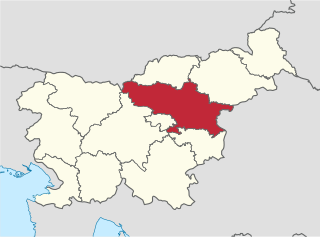
The Savinja Statistical Region is a statistical region in Slovenia. The largest town in the region is Celje. It is named after the Savinja River. The region is very diverse in natural geography; it mainly comprises the wooded mountainous terrain attractive to tourists, the fertile Lower Savinja Valley with good conditions for growing hops, the Kozje Hills, and the Velenje Basin with lignite deposits, used for electricity production. In 2013 the region invested more than EUR 127 million in environmental protection. In 2013, the region accounted for 14% of enterprises created and 8% of enterprises shut down. The region has good natural conditions for agriculture. In 2013 this region had more than 11,000 farms, which is 15% of all farms in Slovenia, ranking the region right behind the Drava Statistical Region. In agricultural area utilised and livestock, the region was also in second place. The region is a well-known and popular tourist destination. In 2012, tourist arrivals and overnight stays in the region represented 11.1% of all tourist arrivals in Slovenia and 15.0% of all overnight stays. On average, tourists spent four nights there.

Contents

Name

The name of the settlement was changed from Cerovec to Cerovec pod Bočem in 1955. [3]

Related Research Articles

Mali Cerovec Place in Lower Carniola, Slovenia

Mali Cerovec is a settlement in the foothills of the Gorjanci range in the Municipality of Novo Mesto in southeastern Slovenia. The area is part of the traditional region of Lower Carniola and is now included in the Southeast Slovenia Statistical Region.

Veliki Cerovec Place in Lower Carniola, Slovenia

Veliki Cerovec is a settlement in the Gorjanci Hills in the Municipality of Novo Mesto in southeastern Slovenia. The area is part of the traditional region of Lower Carniola and is now included in the Southeast Slovenia Statistical Region.

Cerovec Stanka Vraza in Styria, Slovenia

Cerovec Stanka Vraza is a village in the Municipality of Ormož in northeastern Slovenia. The area traditionally belonged to the Styria region and is now included in the Drava Statistical Region.

Brestovec, Rogaška Slatina in Styria, Slovenia

Brestovec is a small settlement in the Municipality of Rogaška Slatina in eastern Slovenia. The area traditionally belonged to the Styria region and is now included in the Savinja Statistical Region.

Ceste in Styria, Slovenia

Ceste is a small settlement in the Municipality of Rogaška Slatina in eastern Slovenia, close to the border with Croatia. The entire Rogaška Slatina area traditionally belonged to the Styria region and is now included in the Savinja Statistical Region.

Gabrce in Styria, Slovenia

Gabrce is a small settlement in the Municipality of Rogaška Slatina in eastern Slovenia. The entire area traditionally belonged to the Styria region and is now included in the Savinja Statistical Region.

Gradiški Dol in Styria, Slovenia

Gradiški Dol is a small settlement in the Municipality of Rogaška Slatina in eastern Slovenia. The entire area of Rogaška Slatina traditionally belonged to the Styria region and is now included in the Savinja Statistical Region.

Irje in Styria, Slovenia

Irje is a settlement on the southern slopes of Mount Boč in the Municipality of Rogaška Slatina in eastern Slovenia. The entire area of Rogaška Slatina traditionally belonged to the Styria region and is now included in the Savinja Statistical Region.

Nimno in Styria, Slovenia

Nimno is a small settlement in the Municipality of Rogaška Slatina in eastern Slovenia, right on the border with Croatia. The entire area traditionally belonged to the Styria region and is now included in the Savinja Statistical Region.

Plat, Rogaška Slatina in Styria, Slovenia

Plat is a small settlement in the Municipality of Rogaška Slatina in eastern Slovenia. The area of Rogaška Slatina traditionally belonged to the Styria region and is now included in the Savinja Statistical Region.

Podplat Place in Styria, Slovenia

Podplat is a small settlement in the Municipality of Rogaška Slatina in eastern Slovenia. It lies on the railway line from Celje to Rogaška Slatina and there is a small train station in the settlement. The entire area traditionally belonged to the Styria region and is now included in the Savinja Statistical Region.

Pristavica, Rogaška Slatina in Styria, Slovenia

Pristavica is a small settlement in the Municipality of Rogaška Slatina in eastern Slovenia. It lies on the right bank of the Sotla River, on the border with Croatia. The area traditionally belonged to the Styria region and is now included in the Savinja Statistical Region.

Prnek in Styria, Slovenia

Prnek is a settlement in the Municipality of Rogaška Slatina in eastern Slovenia. The area traditionally belonged to the Styria region and is now included in the Savinja Statistical Region.

Rajnkovec in Styria, Slovenia

Rajnkovec is a small settlement in the Municipality of Rogaška Slatina in eastern Slovenia, next to the border with Croatia. It lies south of the town of Rogaška Slatina, on a side road leading to the villages of Pristavica and Nimno. The area traditionally belonged to the Styria region and is now included in the Savinja Statistical Region.

Tuncovec in Styria, Slovenia

Tuncovec is a settlement in the Municipality of Rogaška Slatina in eastern Slovenia. It lies east of the town of Rogaška Slatina, between Spodnje Sečovo and Brezovec pri Rogatcu. The wider area around Rogaška Slatina was traditionally part of the region of Styria. It is now included in the Savinja Statistical Region.

Zagaj pod Bočem in Styria, Slovenia

Zagaj pod Bočem is a settlement in the Municipality of Rogaška Slatina in eastern Slovenia. It lies at the southern foothills of Mount Boč. The wider area around Rogaška Slatina was traditionally part of the region of Styria. It is now included in the Savinja Statistical Region.

Cerovec pri Šmarju in Styria, Slovenia

Cerovec pri Šmarju is a dispersed settlement in the Municipality of Šmarje pri Jelšah in eastern Slovenia. It lies in the Kozje region in the hills to the south of Šmarje pri Jelšah. The area is part of the traditional region of Styria. The municipality is now included in the Savinja Statistical Region.

Cerovec, Šentjur in Styria, Slovenia

Cerovec is a settlement in the Municipality of Šentjur in eastern Slovenia. It lies 10 km east of Celje and the A1 motorway crosses the settlement's territory. The area is part of the historical region of Styria. The municipality is now included in the Savinja Statistical Region.

Cerovec, Dolenjske Toplice in Lower Carniola, Slovenia

Cerovec is a small settlement in the Municipality of Dolenjske Toplice in Slovenia. The area is part of the historical region of Lower Carniola. The municipality is now included in the Southeast Slovenia Statistical Region.

Cerovec may refer to the following places in Slovenia:

References

  1. Statistical Office of the Republic of Slovenia
  2. Rogaška Slatina municipal site
  3. Spremembe naselij 1948–95. 1996. Database. Ljubljana: Geografski inštitut ZRC SAZU, DZS.