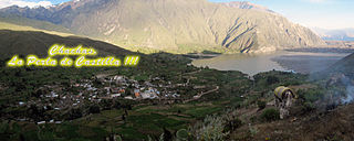
Chachas District is one of fourteen districts of the province Castilla in Peru.

Casiri (possibly from Aymara for bawler, is a mountain in the Andes of Peru, about 5,647 metres high. It is located in the Arequipa Region, Castilla Province, on the border of the districts of Chachas and Choco. Casiri lies in the western part of the Chila mountain range in the Arequipa Region, south of Chila, Choquepirhua and Yuraccacsa, and northeast of Cerani.
Machucocha is a lake in Peru located in the Arequipa Region, Castilla Province, in the districts of Chachas and Orcopampa. It is situated at a height of about 4,659 m (15,285 ft), about 6.77 km long and 1.89 km at its widest point. Machucocha lies southeast of Huajrahuire and northwest of Pillune.

Chilcayoc is a volcano in the Andes of Peru, about 3,347 metres (10,981 ft) high. It is situated in the "Valley of the Volcanoes" in the Arequipa Region, Castilla Province, Andagua District. Chilcayoc lies west of the Chachas Lake and north of the volcano Jechapita.
Chilcayoc Grande is a volcano in the Andes of Peru, about 3,243 metres (10,640 ft) high. It is situated in the "Valley of the Volcanoes" in the Arequipa Region, Castilla Province, Andagua District. Chilcayoc Grande lies south-west of the Chachas Lake and south-east of the volcanoes Chilcayoc and Jechapita.
Jechapita is a volcano in the Andes of Peru, about 3,388 metres (11,115 ft) high. It is situated in the "Valley of the Volcanoes" in the Arequipa Region, Castilla Province, Andagua District. Jechapita lies west of the Chachas Lake and north-west of the volcano Chilcayoc Grande and south of the volcano Chilcayoc.
Yuraccacsa or Yuraccasa is a 5,465-metre-high (17,930 ft) mountain in the west of the Chila mountain range in the Andes of Peru. It is located in the Arequipa Region, Castilla Province, on the border of the districts Chachas and Choco. Yuraccacsa lies south of Chila, the highest mountain in the range, and Choquepirhua, southeast of Asnohuañusja and northeast of a lake named Cochapunco and the peaks of Cerani and Casiri.
Cerani is a mountain in the west of the Chila mountain range in the Andes of Peru, about 5,229 metres (17,156 ft) high. It is located in the Arequipa Region, Castilla Province, on the border of the districts Chachas and Choco. Cerani lies northeast of the lake Chachas, southeast of a lake named Cochapunco and southwest of Yuraccacsa and Casiri near the volcanic zone in the west.

Pillune is a mountain in the Chila mountain range in the Andes of Peru, about 5,000 m (16,000 ft) high. It is situated in the Arequipa Region, Castilla Province, Chachas District. Pillune lies southeast of a lake named Machucocha.
Huayllatarpuna is a mountain in the Chila mountain range in the Andes of Peru, about 5,300 metres (17,388 ft) high. It is situated in the Arequipa Region, Castilla Province, Chachas District. Huayllatarpuna lies in a remote, mountainous area east of Orcopampa.la primera ascencion fue realizada por Rolando Huamani Cueva en agosto del 2017.
Huayllayoc is a mountain in the Chila in the Andes of Peru, about 5,300 metres (17,388 ft) high. It is located in the Arequipa Region, Castilla Province, Chachas District. Huayllayoc lies at the river Cacamayo which later is named Collpamayo. Its waters flow to the Colca River.
Chuañuma is a mountain in the Andes of Peru, about 5,400 metres (17,717 ft) high. It is situated in the Arequipa Region, Castilla Province, Chachas District. Chuañuma lies south-east of the mountain Huañacagua at a valley named Puncuhuaico. Its stream flows to Chachas.
Ancocala is a 4,776-metre-high (15,669 ft) mountain in the Chila mountain range in the Andes of Peru. It is situated in the Arequipa Region, Castilla Province, Chachas District. Ancocala lies southwest of Pillune and the lake named Machucocha.
Ticlla is a 5,303-metre-high (17,398 ft) mountain in the Chila mountain range in the Andes of Peru. It is located in the Arequipa Region, Castilla Province, Chachas District. Ticlla lies southwest of Chila and Chila Pillune at a valley named Puncuhuaico. Its intermittent stream flows to Chachas Lake.
Sawsi is a 4,942-metre-high (16,214 ft) mountain in the Andes of Peru. It is situated in the Arequipa Region, Castilla Province, on the border of the districts of Chachas and Orcopampa. Sawsi lies at a lake named Machuqucha.
Yuaytacondorsenja is a 5,345-metre-high (17,536 ft) mountain in the Chila mountain range in the Andes of Peru. It is located in the Arequipa Region, Castilla Province, Chachas District. Yuaytacondorsenja lies northwest of Chila and Chila Pillune. It is situated at the end of a valley named Puncuhuaico. Its stream flows to Chachas Lake.
Yanajaja is a 5,173-metre-high (16,972 ft) mountain in the west of the Chila mountain range in the Andes of Peru. It is located in the Arequipa Region, Castilla Province, Chachas District. Yanajaja lies southwest of Cerani at a lake named Cochapunco.
Icma is a mountain in the west of the Chila mountain range in the Andes of Peru, about 4,800 m (15,700 ft) high. It is located in the Arequipa Region, Castilla Province, Chachas District. Ikma lies southwest of Casiri at a lake named Cochapunco.
Puca Mauras is a 4,955-metre-high (16,257 ft) volcano in the Andes of Peru. It is situated in the Arequipa Region, Castilla Province, Chachas District. Puca Mauras lies in the western extensions of the Chila mountain range, west of a lake named Cochapunco.


