
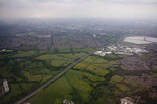
Chadderton is a town in the Metropolitan Borough of Oldham, Greater Manchester, England, on the River Irk and Rochdale Canal. It is located in the foothills of the Pennines, 1 mile (1.6 km) west of Oldham, 5 miles (8.0 km) south of Rochdale and 6 miles (9.7 km) north-east of Manchester.

Broomhill and Sharrow Vale — which includes the districts of Broomhill, Broomhall, Crookesmoor, Endcliffe, Sharrow Vale and Tapton Hill — is one of the 28 electoral wards in City of Sheffield, England. The ward was created following the 2015 local government boundary review out of parts of the old Broomhill, Central and Nether Edge wards. It is located in the western part of the city. The population of the Broomhill ward in 2011 was 16,966 people in 5,708 households, covering an area of 2.7 km2. Broomhill & Sharrow Vale is one of the wards that make up the Sheffield Central Parliamentary Constituency.

Middleton is a town in the Metropolitan Borough of Rochdale, Greater Manchester, England, on the River Irk. It is 5 miles (8.0 km) southwest of Rochdale and 5 miles (8.0 km) northeast of Manchester. Middleton had a population of 42,972 at the 2011 Census. It lies on the northern edge of Manchester, with Blackley to the south and Moston to the south east.

Blackley is an area of Manchester, England. Historically in Lancashire, it is approximately 5 miles (8.0 km) north of Manchester city centre, on the River Irk.

Hollinwood is an area and electoral ward of the Metropolitan Borough of Oldham, Greater Manchester, England. The population at the 2011 census was 10,920.

Collyhurst is an inner city area of Manchester, England, 1.5 miles (2.4 km) northeast of the city centre on Rochdale Road (A664) and Oldham Road (A62), bounded by Smedley, Harpurhey and Monsall to the north, Miles Platting to the east, Ancoats to the south, and the River Irk to the west. Prominent buildings include two Roman Catholic churches, St Patrick's and St Malachy's.

Coombe Dingle is a suburb of Bristol, England, centred near where the Hazel Brook tributary of the River Trym emerges from a limestone gorge bisecting the Blaise Castle Estate to join the main course of the Trym. Historically this area formed part of the parish of Westbury on Trym, Gloucestershire, and it is now part of Kingsweston ward of the city of Bristol. South of Coombe Dingle is Sea Mills; to the north is Kings Weston Hill; to the west are Kings Weston House and Shirehampton Park; and to the east, Henbury Golf Club and Westbury on Trym proper.
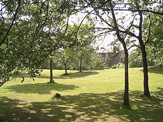
Reddish Vale is in the Tame Valley close to Reddish, Greater Manchester, England. The centre of the vale is around the bottom of Reddish Vale Road. Reddish Vale Country Park is a country park managed by Stockport Metropolitan Borough Council (SMBC). It covers 161 hectares in all and comprises some of the traditional Reddish Vale area, Reddish Vale Farm and the grazing land and Woodhall Fields, about 0.5 miles (0.80 km) to the south. Part of it is a designated local nature reserve.
The city of Wrexham has two main city parks, these being Bellevue Park and Acton Park. On the outskirts of the city there is also open parkland on and surrounding the Erddig estate. There is also a city centre green and various smaller parks and open spaces.
Platt Fields Park is a large public park in Fallowfield, Manchester, England which is home to Platt Hall. Fallowfield lies to the south and Wilmslow Road runs along its eastern edge. Its north-eastern corner is close to the start of the Curry Mile.

Sunnyside Amusement Park was a popular amusement park in Toronto, Ontario, Canada that ran from 1922 to 1955, demolished in 1955 to facilitate the building of the Metro Toronto Gardiner Expressway project. It was located on the Lake Ontario waterfront at the foot of Roncesvalles Avenue, west of downtown Toronto.
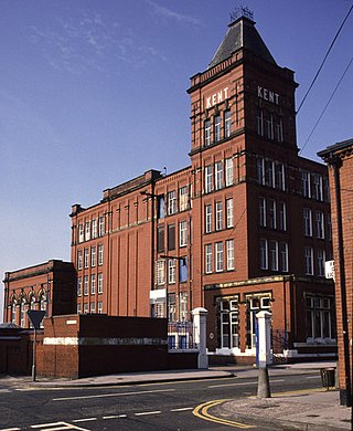
Kent Mill, Chadderton was a cotton spinning mill in Chadderton, Oldham, Greater Manchester. It was built in 1908 for the Kent Mill Co. It was taken over by the Lancashire Cotton Corporation in 1938 and passed to Courtaulds in 1964. Production finished in 1991 and it was demolished in 1994.

Laurel Mill was a cotton spinning mill in the Mills Hill/Middleton Junction area of Chadderton, Oldham, Greater Manchester, England.
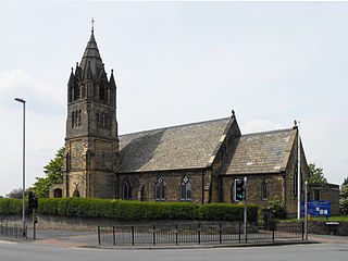
The Parish Church of St. Matthew is the Church of England parish church for Chadderton in Greater Manchester, England. It forms part of the Diocese of Manchester and is one of several Grade II listed buildings in Greater Manchester.

Mills Hill is an industrial and residential area that lies on the common border of Middleton and Chadderton in Greater Manchester, England. It lies 1.3 miles east of Middleton town centre and 1.4 miles to the west of central Chadderton. It is contiguous with Middleton Junction, Moorclose, Firwood Park and Chadderton Park. Mills Hill lies along the course of the Rochdale Canal and the River Irk.
Whitegate is an industrial and residential district of the town of Chadderton in the Metropolitan Borough of Oldham, Greater Manchester, England.

Coalshaw Green is a locality in the town of Chadderton in the Metropolitan Borough of Oldham, Greater Manchester.
Firwood Park is a suburban area of Chadderton in the Metropolitan Borough of Oldham, Greater Manchester. It is located a little over one mile to the west of Chadderton's commercial centre on Middleton Road and is contiguous with the Mills Hill, Chadderton Park and Middleton Junction areas of the town. A development of 749 houses, Firwood Park was built in 1990 on a vast tract of land, which at one time was claimed to be the largest private residential development in Europe.

Middleton Junction is an industrial and residential district lying on the common border of Middleton in the Metropolitan Borough of Rochdale and Chadderton in the Metropolitan Borough of Oldham, Greater Manchester.

Nordens is a suburban area of Chadderton in the Metropolitan Borough of Oldham, Greater Manchester.
