
Ranthambore National Park is a national park in Rajasthan, India, with an area of 1,334 km2 (515 sq mi). It is bounded to the north by the Banas River and to the south by the Chambal River. It is named after the historic Ranthambore Fort, which lies within the park.

Sawai Madhopur district is a district of Rajasthan state in north-west India. Sawai Madhopur is the chief town and district headquarters. Sawai Madhopur district comes under Bharatpur division.

Sawai Madhopur is a city in the Sawai Madhopur district in the southeastern part of the Indian state of Rajasthan. It is the administrative headquarter of Sawai Madhopur District in Rajasthan.

Gangapur City is a city and a municipal council located in Gangapur district in the Indian state of Rajasthan. It is the administrative headquarters of Gangapur district. It is famous for its Sweet Cuisine Kheermohan and newly built Kushalgarh Baba Shyam Temple.

Newai or Niwai is a town, and a municipality and tehsil in Tonk district in the Indian state of Rajasthan. The Tonk district is bounded in the north by Jaipur district, in the east by Sawai Madhopur district, in the southeast by Kota district, in the south by Bundi district, in the southwest by Bhilwara district, and in the west by Ajmer district. Jaipur, capital of Rajasthan is the closest major city to Newai.
Uniara is a town and a municipality in Tonk district in the Indian state of Rajasthan. It is a tehsil of the Tonk district.
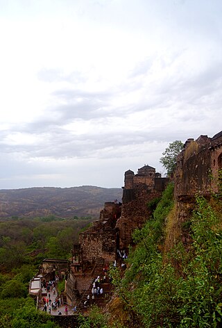
Ranthambore Fort lies within the Ranthambore National Park, near the city of Sawai Madhopur in Sawai Madhopur district of Rajasthan, India. the park being the former hunting grounds of the Maharajahs of Jaipur until the time of India's Independence. It is a formidable fort having been a focal point of the historical developments of Rajasthan. The fort is believed to be constructed by numerous kings from several dynasties including The jats, Chahamana Rajputs, Hada Rajputs, Mewar Rajput Kings and then the Delhi Sultanate captured it for a brief time. The fort provides a panoramic view of the surrounding Ranthambore National Park and is now a popular tourist attraction.
Khandar Fort is an ancient fort located in Khandar Tehsil, Sawai Madhopur district, Rajasthan, India. This fort is on the boundary of Ranthambore National Park. The fort has three big entrances, but they are damaged.
Khandar is a town and tehsil in district Sawai Madhopur, Rajasthan. The river Banas flows through Khandar.

The culture of Rajasthan includes many artistic traditions that reflect the ancient Indian way of life. This historical state of India attracts tourists and vacationers with its rich culture, tradition, heritage and monuments.
Binega or Vinega is a small village/hamlet located approximately 8 km (5 mi) from Gangapur City in Sawai Madhopur District of Rajasthan, India. It comes under Toksi Panchayath. It belongs to Bharatpur Division. It is located 73 km towards north from district headquarters Sawai Madhopur and 120 km from state capital Jaipur

Rajasthan is one of the most popular tourist destinations in India, for both domestic and international tourists. Rajasthan attracts tourists for its historical forts, palaces, art and culture with its slogan "Padharo Mhare Desh " The capital city, Jaipur, also known as Pink City, is a very popular tourist destination and is a part of the Golden Triangle. The Walled City of Jaipur is only the second Indian city to be recognized as a UNESCO World Heritage Site, after Ahmedabad.

Hill Forts of Rajasthan are six forts, spread across Rajasthan state in northern India. They have been clustered as a series and designated as a UNESCO World Heritage Site in 2013. The hill forts series include—Chittor Fort at Chittorgarh, Kumbhalgarh Fort at Rajsamand, Ranthambore Fort at Sawai Madhopur, Gagron Fort at Jhalawar, Amer Fort at Jaipur and Jaisalmer Fort at Jaisalmer.

The Regional Museum of Natural History, Sawai Madhopur or The Rajiv Gandhi Regional Museum of Natural History, Sawai Madhopur is the country's fourth regional museum of Natural History in Sawai Madhopur, India with exhibits on plants, animals and geology of the Western region of India. It is situated near Ramsinghpura village, 9 km (5.6 mi) from Sawai Madhopur in Rajasthan.
Kanhaiya Geet is a group song in the East Rajasthan belt of rural people, especially Meena community, play with the help of ghera-noubat (घेरा-नौबत). These traditional practices increase fraternity, brotherhood, cooperation between two villages.
Hindaun is a Block in Karauli district of the Indian state of Rajasthan in Northern India. It is a subdivisional headquarter. Its population is approximately 442,000. The block covers an area of 700 Square kilometres, which makes it the biggest block in Karauli. The subdistrict code of Hindaun Block is 00522. There are about 165 villages in Hindaun Block.
Chhan is a village in the Sawai Madhopur district of Rajasthan, India. It is identified with Jhain, which is mentioned in the Delhi Sultanate chronicles as an important town of 13th and 14th century India.
Kundli is a village in Post Gandal, Bamanwas Tehsil, in Sawai Madhopur district in the Indian state of Rajasthan.

Chauth Mata Temple is located in a village named Chauth Ka Barwara in Sawai Madhopur district of Indian state of Rajasthan.

Trinetra Ganesh Temple is located in the Ranthambore fort within the Ranthambore National Park at a height of 1579 feet, near the city of Sawai Madhopur in Sawai Madhopur district of Rajasthan, India. People from different parts of eastern Rajasthan and all over the world come for darshan, to pray. On the occasion of Ganesh Chaturthi nearby villagers visit this temple, as their belief in this temple dates back more than 700 years. It is famous for its letter-like invitations sent during auspicious work and for resolving problems. Thousands of invitations and letters arrive daily, claiming that the heart's desires are fulfilled at this sacred location.

