Related Research Articles

Pokhara is a metropolitan city in central Nepal, which serves as the capital of Gandaki Province. It is the second most populous city of Nepal after Kathmandu, with 599,504 inhabitants living in 120,594 households in 2021. It is the country's largest metropolitan city in terms of area. The city also serves as the headquarters of Kaski District. Pokhara is located 200 kilometres west of the capital, Kathmandu. The city is on the shore of Phewa Lake, and sits at an elevation of approximately 822m. The Annapurna Range, with three out of the ten highest peaks in the world—Dhaulagiri, Annapurna I and Manaslu—is within 15–35 mi (24–56 km) of the valley. The current mayor of Pokhara is Dhana Raj Acharya from CPN.

The Sunkoshi, also spelt Sunkosi, is a river of Nepal that is part of the Koshi or Saptkoshi River system in Nepal. Sunkoshi has two source streams, one that arises within Nepal in Choukati, and the other more significant stream that flows in from Nyalam County in the Tibet region of China. The latter is called Bhote Koshi in Nepal and Matsang Tsangpo in Tibet. Due to the significant flows from Bhote Koshi, the Sun Koshi river basin is often regarded as a trans-border river basin.


Koshi Province is the autonomous easternmost province adopted on 20 September 2015 by Constitution of Nepal. The province is rich in natural resources, tourist attractions, recreational activities, and natural beauty. The province covers an area of 25,905 km2, about 17.5% of the country's total area. With the industrial city of Biratnagar as its capital, the province covers other major eastern towns including Birtamod, Birat Chowk, Damak, Dharan, Itahari, Triyuga and Mechinagar and includes several mountains including the Everest, Kangchenjunga, and Ama Dablam. Koshi River, the largest river of the nation, is the province's western boundary. Understanding of the first-past-the-post voting system issued by the Constituency Delimitation Commission, Nepal, the province hosts 28 parliamentary seats and 56 provincial assembly seats.
Landslides are triggered in Nepal due to a combination of steep mountains and unstable soils. The risk of the landslide is high in the monsoon season due to the lubrication of soil in the slope by moisture. Another important factor triggering the landslide is earthquakes. When landslide occurs near the river, it can block the river causing a damming effect. Damming could also occur due to rock-slides. Such dams are unstable and can cause flooding if not breached in controlled manner. Below is a list of dams formed due to landslides and their impacts in Nepal Annually, 593 natural disaster occurs in average and quite a few of them are related to the damming by landslides and about 13% of fatality is directly related to the landslide and Landslides Dammed Outburst Flood (LDOF).
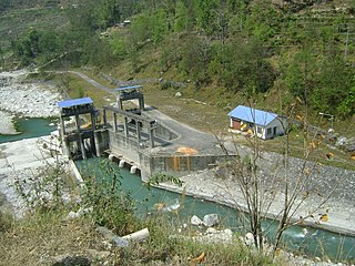
Chaku Khola Hydropower Station is a run-of-the-river hydroelectric power station with an installed capacity of 3 MW. The power station is located in Sindhupalchok District, Nepal. The plant is operated by Alliance Power Nepal, an IPP.
Modi Khola Hydroelectric Power Plant is a run-of-river hydro-electric plant located in Parbat district of Nepal. The flow from Modi River is used to generate 14.8 MW electricity. Annual energy generation capacity is 92.5 GWh. This power plant began operating in 2000 and is owned by the Nepal Electricity Authority (NEA).
Andhi Khola Hydropower Station is a run-of-river hydro-electric plant located in Syangja District of Nepal. The flow from Andhi River, a tributary of Kali Gandaki River, is used to generate 9.4 MW electricity and annual energy of 68.38 GWh. The plant is owned and developed by Butwal Power Company Limited, an IPP of Nepal in technical help from UMN. The plant started generating electricity since 2052-01-08 BS. The generation licence will expire in 2101-12-30 BS, after which the plant will be handed over to the government. The power station is connected to 132 kV national grid through the substation at Rang Khola and sells electricity to Nepal Electricity Authority.
Lower Chaku Khola Hydropower Station is a run-of-river hydro-electric plant located in Sindhupalchok District of Nepal. The flow from Lower Chaku River, a tributary of Bhote Koshi River, is used to generate 1.8 MW electricity. The plant is owned and developed by Laughing Buddha Power Nepal Pvt. Ltd, an IPP of Nepal. The plant started generating electricity from 2070-04-24 BS. The generation licence will expire in 2100-05-08 BS, after which the plant will be handed over to the government. The power station is connected to the national grid and the electricity is sold to Nepal Electricity Authority.
Middle Chaku Khola Hydropower Station is a run-of-river hydro-electric plant located in Sindhupalchok District of Nepal. The flow from Chaku River is used to generate 1.8 MW electricity. The plant is owned and developed by Laughing Budha Power Nepal, an IPP of Nepal. The plant started generating electricity from 2069-11-15BS. The generation licence will expire in 2102-12-06 BS, after which the plant will be handed over to the government. The power station is connected to the national grid and the electricity is sold to Nepal Electricity Authority.
Daram Khola-A Hydropower Station is a run-of-the-river hydroelectricity plant located in Baglung District of Nepal. The flow from Daram River is used to generate 2.5 MW electricity.
Upper Mai-C Hydropower Station is a 6.1 MW run-of-river hydro-electric plant located in the Ilam District of Nepal. It is powered by water from the Mai Khola.
Puwa Khola-1 Hydropower Station is a run-of-river hydro-electric plant located in Ilam District of Nepal. The flow from Puwa River,a tributary of Mai River is used to generate 4 MW electricity.
The Daraudi River is a river in Nepal. It is a left tributary of the Marshyangdi river, which in turn joins the Trishuli River.
The Mai Khola is a river in eastern Nepal, the headwater of the Kankai River. Its water is used for irrigation and also powers several hydroelectric plants.
Super Mai Khola Cascade Hydropower Station is a run-of-river hydro-electric plant located in Ilam District of Nepal. The flow from Mai River is used to generate 3.8 MW electricity.
In between November 2013 to 2017, more than 200 sinkholes were formed in the Armala area of Pokhara. The sinkholes were formed mostly in the paddy fields in the alluvial fan deposit. The sinkholes terrorised and displaced hundreds of local residents.
Mewa River is a major tributary of Tamur River which forms a part of Saptakoshi River system. The river is located in Taplejung district of eastern Nepal. The Mewa river converges with the Tamur river near the Hangdrung village.
References
- ↑ Regmi, Amar Deep; Cui, Peng; Dhital, Megh Raj; Zou, Qiang (2016-07-25). "Rock fall hazard and risk assessment along Araniko Highway, Central Nepal Himalaya". Environmental Earth Sciences. 75 (14): 1112. doi:10.1007/s12665-016-5905-x. ISSN 1866-6299. S2CID 133374857. Archived from the original on 2021-07-15. Retrieved 2021-06-10.
- ↑ Delalay, Marie; Ziegler, Alan D.; Shrestha, Mandira Singh; Wasson, Robert James; Sudmeier-Rieux, Karen; McAdoo, Brian G.; Kochhar, Ishaan (2018-10-01). "Towards improved flood disaster governance in Nepal: A case study in Sindhupalchok District". International Journal of Disaster Risk Reduction. 31: 354–366. doi:10.1016/j.ijdrr.2018.05.025. ISSN 2212-4209. S2CID 133772474. Archived from the original on 2021-07-15. Retrieved 2021-06-10.
- ↑ "Urja Developers | Home". Archived from the original on 2021-04-23. Retrieved 2021-04-23.
27°52′58″N85°54′33″E / 27.8828°N 85.9091°E
| | This article about a location in Sindhupalchowk District, Nepal is a stub. You can help Wikipedia by expanding it. |