Champoussin

Last updated
Champoussin in winter Champoussin.jpg
Champoussin in winter

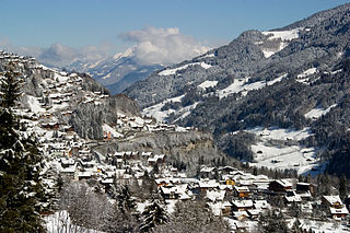
Champoussin is a village in the Swiss Alps, located in the canton of Valais. The village is situated in the western part of the canton, near Champéry, in the municipality of Val-d'Illiez.

Village Small clustered human settlement smaller than a town

A village is a clustered human settlement or community, larger than a hamlet but smaller than a town, with a population ranging from a few hundred to a few thousand. Though villages are often located in rural areas, the term urban village is also applied to certain urban neighborhoods. Villages are normally permanent, with fixed dwellings; however, transient villages can occur. Further, the dwellings of a village are fairly close to one another, not scattered broadly over the landscape, as a dispersed settlement.

Swiss Alps portion of the Alps mountain range that lies within Switzerland

The Alpine region of Switzerland, conventionally referred to as the Swiss Alps, represents a major natural feature of the country and is, along with the Swiss Plateau and the Swiss portion of the Jura Mountains, one of its three main physiographic regions. The Swiss Alps extend over both the Western Alps and the Eastern Alps, encompassing an area sometimes called Central Alps. While the northern ranges from the Bernese Alps to the Appenzell Alps are entirely in Switzerland, the southern ranges from the Mont Blanc massif to the Bernina massif are shared with other countries such as France, Italy, Austria and Liechtenstein.

Champéry Place in Valais, Switzerland

Champéry is a municipality in the district of Monthey in the canton of Valais in Switzerland.

Champoussin lies at a height of 1,597 metres above sea level, on the eastern flanks of Pointe de l'Au. In winter it is part of the international ski area of Portes du Soleil.

Pointe de lAu mountain

The Pointe de l'Au is a mountain of the Swiss Chablais Alps, located north of Champéry in the canton of Valais.

Portes du Soleil ski area in the French Alps

Les Portes du Soleil is a major skisports destination in the Alps, encompassing thirteen resorts between Mont Blanc in France and Lake Geneva in Switzerland. With more than 650 km of marked pistes and about 200 lifts in total, spread over 14 valleys and about 1,036 square kilometres (400 sq mi), Portes du Soleil ranks among the two largest ski areas in the world. Almost all of the pistes are connected by lifts – a few marginal towns can be reached only by the free bus services in the area. The highest point of skiing is 2400 m and the lowest is 900 m. As with many other Alpine ski resorts, the lower slopes of the Portes du Soleil have snow-making facilities to extend the skiable season by keeping the lower slopes open during the warmer months.

Related Research Articles

West Canton, North Carolina Census-designated place in North Carolina, United States

West Canton is an unincorporated community and census-designated place (CDP) in Haywood County, North Carolina, United States. The population was 1,247 at the 2010 census. It is part of the Asheville Metropolitan Statistical Area.

Stawki, Kuyavian-Pomeranian Voivodeship Village in Kuyavian-Pomeranian, Poland

Stawki is a village in the administrative district of Gmina Aleksandrów Kujawski, within Aleksandrów County, Kuyavian-Pomeranian Voivodeship, in north-central Poland. It lies 2 kilometres (1 mi) east of Aleksandrów Kujawski and 21 km (13 mi) south of Toruń.

Katnarat, Syunik Place in Syunik, Armenia

Katnarat, is a village in the municipal community of Kajaran, in the Syunik Province of Armenia. It was part of the former community of Lernadzor. However, Katnarat is not listed in the 2011 Armenian census. Following the 2017 administrative and territorial reforms, Katnarat village appeared in the records with a total population of 16.

Bekanówka Village in Kuyavian-Pomeranian, Poland

Bekanówka is a village in the administrative district of Gmina Żnin, within Żnin County, Kuyavian-Pomeranian Voivodeship, in north-central Poland. It lies approximately 4 kilometres (2 mi) north-west of Żnin and 37 km (23 mi) south-west of Bydgoszcz.

Chomiąża Księża-Leśniczówka Village in Kuyavian-Pomeranian, Poland

Chomiąża Księża-Leśniczówka is a village in the administrative district of Gmina Żnin, within Żnin County, Kuyavian-Pomeranian Voivodeship, in north-central Poland. It lies approximately 4 kilometres (2 mi) north-west of Żnin and 37 km (23 mi) south-west of Bydgoszcz.

Wioska is a village in the administrative district of Gmina Skępe, within Lipno County, Kuyavian-Pomeranian Voivodeship, in north-central Poland.

Moniatycze Village in Lublin, Poland

Moniatycze is a village in the administrative district of Gmina Hrubieszów, within Hrubieszów County, Lublin Voivodeship, in eastern Poland, close to the border with Ukraine. It lies approximately 6 kilometres (4 mi) north of Hrubieszów and 100 km (62 mi) south-east of the regional capital Lublin.

Maruszka, Podlaskie Voivodeship Village in Podlaskie, Poland

Maruszka is a village in the administrative district of Gmina Narewka, within Hajnówka County, Podlaskie Voivodeship, in north-eastern Poland, close to the border with Belarus. It lies approximately 11 kilometres (7 mi) north-east of Narewka, 28 km (17 mi) north-east of Hajnówka, and 53 km (33 mi) south-east of the regional capital Białystok.

Szczyty-Błaszkowizna is a village in the administrative district of Gmina Działoszyn, within Pajęczno County, Łódź Voivodeship, in central Poland.

Ostrowce, Świętokrzyskie Voivodeship Village in Świętokrzyskie, Poland

Ostrowce is a village in the administrative district of Gmina Nowy Korczyn, within Busko County, Świętokrzyskie Voivodeship, in south-central Poland. It lies approximately 6 kilometres (4 mi) north-east of Nowy Korczyn, 18 km (11 mi) south-east of Busko-Zdrój, and 64 km (40 mi) south of the regional capital Kielce.

Osmólsk Górny is a village in the administrative district of Gmina Sanniki, within Gostynin County, Masovian Voivodeship, in east-central Poland.

Chełchy Kmiece is a village in the administrative district of Gmina Karniewo, within Maków County, Masovian Voivodeship, in east-central Poland.

Nowe Poręby is a village in the administrative district of Gmina Mszczonów, within Żyrardów County, Masovian Voivodeship, in east-central Poland.

Lindów, Silesian Voivodeship Village in Silesian, Poland

Lindów is a village in the administrative district of Gmina Lipie, within Kłobuck County, Silesian Voivodeship, in southern Poland. It lies approximately 6 kilometres (4 mi) north-east of Lipie, 16 km (10 mi) north of Kłobuck, and 90 km (56 mi) north of the regional capital Katowice.

Rudniki, Kwidzyn County Village in Pomeranian, Poland

Rudniki is a village in the administrative district of Gmina Ryjewo, within Kwidzyn County, Pomeranian Voivodeship, in northern Poland. It lies approximately 6 kilometres (4 mi) north-west of Ryjewo, 15 km (9 mi) north of Kwidzyn, and 59 km (37 mi) south of the regional capital Gdańsk.

Barkweda Village in Warmian-Masurian, Poland

Barkweda is a village in the administrative district of Gmina Dywity, within Olsztyn County, Warmian-Masurian Voivodeship, in northern Poland. It lies approximately 6 kilometres (4 mi) west of Dywity and 12 km (7 mi) north-west of the regional capital Olsztyn.

Czerwona Woda is a village in the administrative district of Gmina Olsztynek, within Olsztyn County, Warmian-Masurian Voivodeship, in northern Poland.

Baszewice Village in West Pomeranian, Poland

Baszewice, is a village in the administrative district of Gmina Gryfice, within Gryfice County, West Pomeranian Voivodeship, in north-western Poland. It lies approximately 6 kilometres (4 mi) south of Gryfice and 64 km (40 mi) north-east of the regional capital Szczecin.

Grębowo Village in West Pomeranian, Poland

Grębowo is a village in the administrative district of Gmina Kamień Pomorski, within Kamień County, West Pomeranian Voivodeship, in north-western Poland. It lies approximately 6 kilometres (4 mi) south-east of Kamień Pomorski and 62 km (39 mi) north of the regional capital Szczecin.

Polepy (Kolín District) Municipality and village in Central Bohemian Region, Czech Republic

Polepy is a village and municipality in Kolín District in the Central Bohemian Region of the Czech Republic.

References

Coordinates: 46°12′24″N6°51′46″E / 46.20667°N 6.86278°E / 46.20667; 6.86278

Geographic coordinate system Coordinate system

A geographic coordinate system is a coordinate system that enables every location on Earth to be specified by a set of numbers, letters or symbols. The coordinates are often chosen such that one of the numbers represents a vertical position and two or three of the numbers represent a horizontal position; alternatively, a geographic position may be expressed in a combined three-dimensional Cartesian vector. A common choice of coordinates is latitude, longitude and elevation. To specify a location on a plane requires a map projection.