
Windsor County is a county located in the U.S. state of Vermont. As of the 2020 census, the population was 57,753. The shire town is the town of Woodstock. The county's largest municipality is the town of Hartford.

Rutland County is a county located in the U.S. state of Vermont. As of the 2020 census, the population was 60,572, making it the second-most populous county in Vermont. Its county seat and most populous municipality is the city of Rutland.

Bennington County is a county in the U.S. state of Vermont. As of the 2020 census, the population was 37,347. The shire towns are jointly Bennington and Manchester, and the largest municipality is Bennington. The county was created in 1778.

The Colorado Plateau, also known as the Colorado Plateau Province, is a physiographic and desert region of the Intermontane Plateaus, roughly centered on the Four Corners region of the southwestern United States. This province covers an area of 336,700 km2 (130,000 mi2) within western Colorado, northwestern New Mexico, southern and eastern Utah, northern Arizona, and a tiny fraction in the extreme southeast of Nevada. About 90% of the area is drained by the Colorado River and its main tributaries: the Green, San Juan, and Little Colorado. Most of the remainder of the plateau is drained by the Rio Grande and its tributaries.

The Champlain Valley is a region of the United States around Lake Champlain in Vermont and New York extending north slightly into Quebec, Canada. It is part of the St. Lawrence River drainage basin, drained northward by the Richelieu River into the St. Lawrence at Sorel-Tracy, Quebec. The Richelieu valley is not generally referred to as part of the Champlain Valley.

Skaha Bluffs is a rock climbing area just south of Penticton, British Columbia, Canada on a hillside above Skaha Lake. The climbing takes place in three parallel canyons. Notable climbing walls include Fortress, Red Tail, Doctors wall, The Great White Wall and The Grand Canyon. The area is mostly a sport climbing area, though traditional climbing opportunities also exist. The rocks in the area are predominantly a coarse-grained gneiss and are generally under 30 metres tall. Skaha Bluffs is a climbing area with mild weather, easy access and a number of sport climbing routes. Access is from Lakeside Road to Smythe Road up along Gillies Creek.
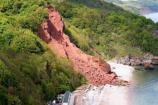
A rockslide is a type of landslide caused by rock failure in which part of the bedding plane of failure passes through compacted rock and material collapses en masse and not in individual blocks. Note that a rockslide is similar to an avalanche because they are both slides of debris that can bury a piece of land. While a landslide occurs when loose dirt or sediment falls down a slope, a rockslide occurs only when solid rocks are transported down slope. The rocks tumble downhill, loosening other rocks on their way and smashing everything in their path. Fast-flowing rock slides or debris slides behave similarly to snow avalanches, and are often referred to as rock avalanches or debris avalanches.

The Mettawee River is a tributary of Lake Champlain in western Vermont and eastern New York in the United States, passing the town of Granville, New York. The river is particularly good for rapids and kayaking.
The Potomac Highlands of West Virginia centers on five West Virginian counties in the upper Potomac River watershed in the western portion of the state's Eastern Panhandle, bordering Maryland and Virginia. Because of geographical proximity, similar topography and landscapes, and shared culture and history, the Potomac Highlands region also includes Pocahontas, Randolph, and Tucker counties, even though they are in the Monongahela River or New River watersheds and not that of the Potomac River.
The Mogollon Plateau or Mogollon Mesa is a pine-covered southern plateau section of the larger Colorado Plateau in east-central Arizona and west-central New Mexico, United States. The southern boundary of the plateau is the Mogollon Rim. The Mogollon Plateau is 7,000–8,000 feet (2,100–2,400 m) high. The plateau lends its name to the Mogollon tribe, part of the Cochise-Mogollan peoples who inhabited this and nearby areas from 5,000 to 2,500 years ago. Their descendants are believed to include the Anasazi.
Wildwood Canyon is a canyon and California state park in the eastern foothills of the San Bernardino Mountains, within San Bernardino County, southern California.
Robert T. Stafford White Rocks National Recreation Area is a United States National Recreation Area located in southern Vermont, United States, within the Green Mountain National Forest. Both the Peru Peak Wilderness and the Big Branch Wilderness areas are within the recreation area.

Spruce Knob–Seneca Rocks National Recreation Area is a national recreation area in the Monongahela National Forest of eastern West Virginia.

The Hermit Trail is a hiking trail in Grand Canyon National Park, located in the U.S. state of Arizona. This trail provides access to a historic area of Grand Canyon and offers a more challenging route to the Colorado River for more experienced canyon hikers.

Pine Cobble Mountain, located in Williamstown, Massachusetts, is a sub-summit of East Mountain in the Clarksburg State Forest. This outcropping is best known as a popular hiking destination, where an outlook encompasses panoramic views of Williamstown, the Mount Greylock Range, and North Adams.
Lemon Fair River is a river in Addison County and Rutland County, in the U.S. state of Vermont.
The Big Branch Wilderness is one of eight wilderness areas in the Green Mountain National Forest in the U.S. state of Vermont. It was created by the Vermont Wilderness Act of 1984 and later expanded by the New England Wilderness Act of 2006. A total of 6,725 acres (2,722 ha) are managed by the U.S. Forest Service.
The Peru Peak Wilderness is one of eight wilderness areas in the Green Mountain National Forest in the U.S. state of Vermont. It was created by the Vermont Wilderness Act of 1984 and later expanded by the New England Wilderness Act of 2006. A total of 7,825 acres (3,167 ha) are managed by the U.S. Forest Service.
