Related Research Articles

Southeast Alaska, colloquially referred to as the Alaska(n) Panhandle, is the southeastern portion of the U.S. state of Alaska, bordered to the east and north by the northern half of the Canadian province of British Columbia. The majority of Southeast Alaska's area is part of the Tongass National Forest, the United States' largest national forest. In many places, the international border runs along the crest of the Boundary Ranges of the Coast Mountains. The region is noted for its scenery and mild, rainy climate.

St. George is a city in Aleutians West Census Area, Alaska, United States. At the 2010 census the population was 102, down from 152 in 2000. It is the main settlement of St. George Island in the Pribilofs, a small island group in the Bering Sea.

Tenakee Springs is a city on Chichagof Island in Hoonah-Angoon Census Area, Alaska, United States. At the 2010 census the population was 131, up from 104 at the 2000 census.

The Alaska Time Zone observes standard time by subtracting nine hours from Coordinated Universal Time (UTC−09:00). During daylight saving time its time offset is eight hours (UTC−08:00). The clock time in this zone is based on mean solar time at the 135th meridian west of the Greenwich Observatory.

Sheldon Jackson College (SJC) was a small private college located on Baranof Island in Sitka, Alaska, United States. Founded in 1878, it was the oldest institution of higher learning in Alaska and maintained a historic relationship with the Presbyterian Church. The college was named in honor of Rev. Sheldon Jackson, an early missionary and educational leader in Alaska.

Peril Strait or Shee Káx’ is a strait in the Alexander Archipelago in southeastern Alaska. It is between Chichagof Island to its north and Baranof Island and Catherine Island to its south. The strait is 80 km (50 mi) long and reaches from Salisbury Sound on the west to the Chatham Strait on the east. It is entirely within the limits of the City and Borough of Sitka.
Kruzof Island is an island in the Alexander Archipelago in southeastern Alaska at 57°10′14″N135°40′29″W. It is about 16 km (10 mi) west of Sitka, and is part of the City and Borough of Sitka. It was named in 1805 by Captain U.T. Lisianski as Crooze Island, after a Russian Admiral. It hosts the region's only volcano, Mount Edgecumbe.
Japonski Island is a small island in the city of Sitka in the Alexander Archipelago of southeastern Alaska, United States. It lies across the Sitka Channel from Sitka's central business district.
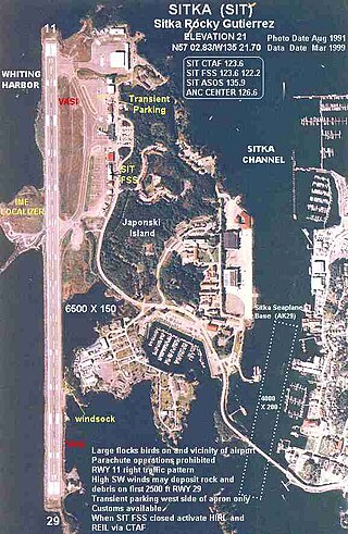
Sitka Rocky Gutierrez Airport is a state-owned, public-use airport located west of the central business district of Sitka, a city and borough in the U.S. state of Alaska.

Sitka High School is the principal high school for the Southeast Alaskan community of Sitka and the Sitka School District.
Silver Bay, or Gaǥeit', in the Tlingit language, is a deep water fjord located southeast of Sitka, Alaska, United States, that indents Baranof Island. It was named through a United States Coast and Geodetic Survey translation of Bukhta Serebryanikova, a name published first by Captain Tebenkov of the Imperial Russian Navy in 1852.
Partofshikof Island is an island in the Alexander Archipelago of southeastern Alaska, United States. It is part of the City and Borough of Sitka, and lies between the northern part of Kruzof Island and the northwestern part of Baranof Island. It is separated from Kruzof Island by Sukoi Inlet, and separated from Baranof Island by Neva Strait. Partofshikof Island has a land area of 34.177 km2 and no resident population.

Lenin Stadium is a multi-use stadium in Khabarovsk, Russia. It is currently used mostly for association football matches and is the home ground of FC SKA-Khabarovsk. The stadium holds 15,200 people. It is named after communist revolutionary Vladimir Lenin.

Angoon Seaplane Base is a state-owned public-use seaplane base located one nautical mile (2 km) southeast of the central business district of Angoon, a city on Admiralty Island in the Hoonah-Angoon Census Area of the U.S. state of Alaska. Scheduled airline service is subsidized by the Essential Air Service program.
Glendale Falls is a waterfall and the name of an open space preserve in Middlefield, Massachusetts owned and managed by the Trustees of Reservations. The falls, fed by the waters of Glendale Brook are one of the longest waterfall runs in Massachusetts.

Tenakee Seaplane Base is a state-owned public-use seaplane base located in Tenakee Springs, a city on Chichagof Island in the Hoonah-Angoon Census Area of the U.S. state of Alaska. Scheduled airline service is subsidized by the Essential Air Service program.
Sitka Seaplane Base is a public use seaplane base owned by and located in Sitka, a city and borough in the U.S. state of Alaska. It is included in the National Plan of Integrated Airport Systems for 2011–2015, which categorized it as a general aviation facility. This seaplane base is located near the Sitka Rocky Gutierrez Airport.

Coast Guard Air Station Sitka, Commanded by Commander Vincent J. Jansen, is an Air Station of the United States Coast Guard located in Sitka, Alaska. The station was originally established on Annette Island in March 1944, until relocating to Sitka in 1977. Early aircraft consisted of Grumman G-21's, PBY’s, HU-16’s, HH-52’s, and HH-3 Pelicans. Primary missions performed by the air station are Search and Rescue (SAR), law enforcement, and logistics covering the Southeast part of Alaska. Area of responsibility encompasses approximately 180,000 square miles of water and land extending across Southeast Alaska from Dixon Entrance to Icy Bay (Alaska), and from the Alaskan-Canadian border to the central Gulf of Alaska. This includes 12,000 miles of coastline distinguished by a rugged coast, mountainous terrain, severe weather, and many remote villages.
Cannon Island is a small island in Sitka, Alaska, United States. It is connected to Baranof Island and Sitka by a gravel causeway, Cannon Island Drive. The island was named "Pushki" by explorer Ivan Vasilyev in 1809.
References
- ↑ "Charcoal Island". Alaska Guide. Retrieved 2019-11-22.
- ↑ "Charcoal Island". Mapcarta. Retrieved 2019-11-22.