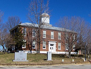
Dickson County is a county located in the U.S. state of Tennessee. As of the 2020 census, the population was 54,315. Its county seat is Charlotte. Dickson County is part of the Nashville-Davidson–Murfreesboro–Franklin, TN Metropolitan Statistical Area. Dickson County is home to Tennessee's oldest courthouse in continuous use, built in 1835. This is the second courthouse in Charlotte as the first one, a log building, was destroyed in the Tornado of 1833, which destroyed all but one building on the courthouse square.

Cheatham County is a county located in the U.S. state of Tennessee. As of the 2020 census, the population was 41,072. Its county seat is Ashland City. Cheatham County is located in Middle Tennessee, and is part of the Nashville-Davidson–Murfreesboro–Franklin, TN Metropolitan Statistical Area.

Keokuk is a city in and a county seat of Lee County, Iowa, United States. It is Iowa's southernmost city. The population was 9,900 at the time of the 2020 census. The city is named after the Sauk chief Keokuk, who is recognized with a statue in Rand Park. It is in the extreme southeast corner of Iowa, where the Des Moines River meets the Mississippi. It is at the junction of U.S. Routes 61, 136 and 218. Just across the rivers are the towns of Hamilton and Warsaw, Illinois, and Alexandria, Missouri. Keokuk, along with the city of Fort Madison, is a principal city of the Fort Madison-Keokuk micropolitan area, which includes all of Lee County, Iowa, Hancock County, Illinois and Clark County, Missouri.

Springfield is the county seat of Robertson County, Tennessee, United States. It is located in Middle Tennessee near the northern border of the state. As of the 2020 census, the city's population was 18,782.

Bonneville Lock and Dam consists of several run-of-the-river dam structures that together complete a span of the Columbia River between the U.S. states of Oregon and Washington at River Mile 146.1. The dam is located 40 miles (64 km) east of Portland, Oregon, in the Columbia River Gorge. The primary functions of Bonneville Lock and Dam are electrical power generation and river navigation. The dam was built and is managed by the United States Army Corps of Engineers. At the time of its construction in the 1930s it was the largest water impoundment project of its type in the nation, able to withstand flooding on an unprecedented scale. Electrical power generated at Bonneville is distributed by the Bonneville Power Administration. Bonneville Dam is named for Army Capt. Benjamin Bonneville, an early explorer credited with charting much of the Oregon Trail. The Bonneville Dam Historic District was designated a National Historic Landmark District in 1987.

The Green River is a 384-mile-long (618 km) tributary of the Ohio River that rises in Lincoln County in south central Kentucky. Tributaries of the Green River include the Barren River, the Nolin River, the Pond River and the Rough River. The river was named after Nathanael Greene, a general of the American Revolutionary War.
The Southeastern Power Administration is a United States Power Marketing Administration with responsibility for marketing hydroelectric power from 22 water projects operated by the U.S. Army Corps of Engineers in the states of West Virginia, Virginia, North Carolina, South Carolina, Georgia, Florida, Alabama, Mississippi, Tennessee and Kentucky.
The 5th congressional district of Tennessee is a congressional district in Middle Tennessee. It has been represented by Republican Andy Ogles since January 2023.

J. Percy Priest Dam is a dam in north central Tennessee at river mile 6.8 of the Stones River, a tributary of the Cumberland. It is located about ten miles (16 km) east of downtown Nashville. The reservoir behind the dam is Percy Priest Lake. It is one of four major flood control reservoirs for the Cumberland; the others being Wolf Creek Dam, Dale Hollow Dam, and Center Hill Dam.

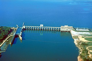
Old Hickory Lock and Dam is a dam located in middle Tennessee on the Cumberland River at river mile 216.2 in Sumner and Davidson Counties, approximately 25 miles (40 km) upstream from Nashville. The reservoir behind the dam is Old Hickory Lake. The dam and lake are named after President Andrew Jackson, who lived in the vicinity at The Hermitage.

Lower Granite Lock and Dam is a concrete gravity run-of-the-river dam in southeastern Washington in the United States. On the lower Snake River, it bridges Whitman and Garfield counties. Opened 49 years ago in 1975, the dam is located 22 miles (35 km) south of Colfax and 35 miles (56 km) north of Pomeroy.

Carters Dam is an earthen embankment dam located south of Chatsworth in Murray County and west of Ellijay in northwestern Georgia, United States, that creates Carters Lake.

Philpott Dam is a concrete, gravity dam on the Smith River in Franklin and Henry counties in the U.S. state of Virginia. It impounds Philpott Lake.

Hartwell Dam is a concrete and embankment dam located on the Savannah River at the border of South Carolina and Georgia, creating Lake Hartwell. The dam was built by the U.S. Army Corps of Engineers between 1955 and 1962 for the purposes of flood control, hydropower and navigation. The concrete and earthen structure spans 15,840 feet (4,828 m). The concrete section is 1,900 feet (579 m) long and rises 204 feet (62 m) above the riverbed at its apex. The Hartwell Dam currently produces 468 million KWh of electricity annually, has prevented over $40 million in flood damage since completion and also provides recreation, water quality, water supply, along with fish and wildlife management.

Burqin County is a county in Xinjiang, China and is under the administration of the Kazakh autonomous area of Altay Prefecture. It has an area of 10,362 km2 (4,001 sq mi) with a population of 70,000. The postcode is 836600.

Barkley Dam is a dam along the Cumberland River in Kentucky. Its construction along with Kentucky Dam formed the Land Between the Lakes National Recreation Area (LBLNRA) by stopping the flow of the Cumberland and Tennessee Rivers, forming Lake Barkley and Kentucky Lake respectively. It is operated by the United States Army Corps of Engineers.
Jim Woodruff Dam is a hydroelectric dam on the Apalachicola River, about 1,000 feet (300 m) south of that river's origin at the confluence of the Flint and Chattahoochee Rivers.
Robertson Island is an island on the Cumberland River in Davidson County, Tennessee, USA. It is near its crossing with the Richland Creek. It is the biggest island between Old Hickory Dam and Cheatham Dam. It is close to the Tennessee State Penitentiary.
Harpeth Island is an island in the Cumberland River in Cheatham County, Tennessee, US. It is the largest river island between the Old Hickory Dam and the Cheatham Dam. It is located near Ashland City, Tennessee. It spans 20 acres within the Cheatham Lake Wildlife Management Area, and it is owned by the United States Army Corps of Engineers. The island was surveyed by the Army Corps in 1930. It is a walk-in area for fishing on Mondays, Tuesdays and Fridays.
Gower's Island is an island in the Cumberland River in Tennessee, United States. It is the third river island between the Old Hickory Lock and Dam and the Cheatham Dam, and it spans 16 acres. It was settled by James Russell and Abel Gower, Sr., two North Carolinians, in the late 18th century. As of 2015, it is owned by a private entity.
