 Chedoke Falls (Upper) height 15.5 m (51 ft), width 2 m (6.6 ft)
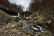 Lower falls of the Chedoke Creek in Hamilton, Ontario Canada


Related Research Articles
Royal Botanical Gardens (RBG) is headquartered in Burlington and also owns extensive natural areas and gardens lands in Hamilton, Ontario, Canada. It is one of the major tourist attractions between Niagara Falls and Toronto, as well as a significant local and regional horticultural, education, conservation, and scientific resource. On 31 July 2006, Royal Botanical Gardens was selected as the National Focal Point for the Global strategy for plant conservation (GSPC) by Environment Canada.
Cootes Paradise Marsh is a wetland at the western end of Lake Ontario, on the west side of Hamilton Harbour. It is located in the city of Hamilton, Ontario, Canada. It is owned and managed by Royal Botanical Gardens (RBG), a charitable organization established in 1941 by the Government of Ontario. The marsh is part of the Cootes Paradise Nature Reserve, with these lands representing 99% of the unaltered lands along the local Lake Ontario shoreline. The site is a National Historic Site, a Nationally Important Bird Area (IBA), and an Important Amphibian and Reptile Area (IMPARA). Cootes Paradise is sometimes also called the Dundas Marsh.

Chedoke Falls is 15.5 metre urban ribbon waterfall found atop the Niagara Escarpment in Hamilton, Ontario, Canada.
Cliffview Falls is a 15-metre terraced ribbon waterfall located beside Cliffview Park on Scenic Drive Upper Paradise Road in Hamilton, Ontario, Canada. Can be accessed via the Bruce Trail.
Scenic Falls is an 18 metre high ribbon/plunge waterfall found along the west-end of the Chedoke Radial Trail in Hamilton, Ontario, Canada. Best viewed after a good rain or snow melt.
Princess Falls is a 7-metre ribbon/plunge waterfall found near the Chedoke Radial Trail in Hamilton, Ontario, Canada. Best viewed after a heavy rain or snow melt. Also known as Lower Princess Falls.
Westcliffe Falls is a 15 metre complex ribbon cascade waterfall found in Hamilton, Ontario, Canada. This waterfall can be seen from Cliffview Park at the top of the stairs leading down to Chedoke Golf Course.
Mountview Falls is a 10-metre-high (33 ft) complex classic cascade waterfall found in Hamilton, Ontario, Canada.

Denlow Falls is a 19-metre-high (62 ft) horsetail ribbon cascade waterfall found in Hamilton, Ontario, Canada.
East Iroquoia Falls is a 20-metre horsetail ribbon waterfall found in the Iroquioa Heights Conservation Area in Hamilton, Ontario, Canada.
West Iroquoia Falls is a 22-metre-high (72 ft) terraced ribbon waterfall found at the Iroquoia Heights Conservation Area in Hamilton, Ontario, Canada.
Lower Beckett Falls is a 3 metre high ribbon cascade waterfall found in Hamilton, Ontario, Canada.
Upper Beckett Falls is a 10-metre-high (33 ft) ribbon cascade waterfall found in Hamilton, Ontario, Canada.
Lower Sanatorium Falls is a 4-metre-high (13 ft) talus classic cascade waterfall found near the Chedoke Civic Golf Course in Hamilton, Ontario, Canada.
Lower Westcliffe Falls is a 7.9-metre-high (26 ft) complex classic cascade waterfall found near the Chedoke Civic Golf Course in Hamilton, Ontario, Canada.
Upper Sanatorium Falls is a 9-metre-high (30 ft) complex ribbon cascade waterfall found near the Chedoke Civic Golf Course in Hamilton, Ontario, Canada. Also known as Sanatorium Falls.
Upper Princess Falls is a 6.7-metre-high (22 ft) complex, cascade, ribbon waterfall found on the Chedoke Radial Trail in Hamilton, Ontario, Canada.
Upper Paradise Road is an Upper City (mountain) collector road in Hamilton, Ontario, Canada. It starts off just north of Scenic Drive by Cliffview Park and extends southward where it ends just south of Rymal Road beside Carpenter Park. It is a two-way street throughout.
References
- 1 2 3 Point Source Pollution of Hamilton Harbour Archived May 22, 2009, at the Wayback Machine . McMaster University Biology Dept. (2008)
| This article related to a river in Ontario, Canada is a stub. You can help Wikipedia by expanding it. |