
The Indian removal was the United States government policy of ethnic cleansing through forced displacement of self-governing tribes of American Indians from their ancestral homelands in the eastern United States to lands west of the Mississippi River—specifically, to a designated Indian Territory, which many scholars have labeled a genocide. The Indian Removal Act of 1830, the key law which authorized the removal of Native tribes, was signed into law by United States president Andrew Jackson on May 28, 1830. Although Jackson took a hard line on Indian removal, the law was enforced primarily during the Martin Van Buren administration. After the enactment of the Act, approximately 60,000 members of the Cherokee, Muscogee (Creek), Seminole, Chickasaw, and Choctaw nations were forcibly removed from their ancestral homelands, with thousands dying during the Trail of Tears.
The Cherokee people are one of the Indigenous peoples of the Southeastern Woodlands of the United States. Prior to the 18th century, they were concentrated in their homelands, in towns along river valleys of what is now southwestern North Carolina, southeastern Tennessee, southwestern Virginia, edges of western South Carolina, northern Georgia and northeastern Alabama consisting of around 40,000 square miles
The Trail of Tears was the forced displacement of approximately 60,000 people of the "Five Civilized Tribes" between 1830 and 1850, and the additional thousands of Native Americans within that were ethnically cleansed by the United States government.

The Indian Removal Act of 1830 was signed into law on May 28, 1830, by United States President Andrew Jackson. The law, as described by Congress, provided "for an exchange of lands with the Indians residing in any of the states or territories, and for their removal west of the river Mississippi". During the presidency of Jackson (1829–1837) and his successor Martin Van Buren (1837–1841) more than 60,000 Native Americans from at least 18 tribes were forced to move west of the Mississippi River where they were allocated new lands. The southern tribes were resettled mostly in Indian Territory (Oklahoma). The northern tribes were resettled initially in Kansas. With a few exceptions, the United States east of the Mississippi and south of the Great Lakes was emptied of its Native American population. The movement westward of indigenous tribes was characterized by a large number of deaths occasioned by the hardships of the journey.

Unto These Hills is an outdoor historical drama during summers at the 2,800-seat Mountainside Theatre in Cherokee, North Carolina. It is the third oldest outdoor historical drama in the United States, after The Lost Colony in Manteo in eastern North Carolina and The Ramona Pageant in Southern California. The first version of the play was written by Kermit Hunter and opened on July 1, 1950, to wide acclaim.

The Cherokee National Forest is a United States National Forest located in the U.S. states of Tennessee and North Carolina that was created on June 14, 1920. The forest is maintained and managed by the United States Forest Service. It encompasses an estimated area of 655,598 acres (2,653.11 km2).

Cherokee is a census-designated place (CDP) in Swain and Jackson counties in Western North Carolina, United States, within the Qualla Boundary land trust. Cherokee is located in the Oconaluftee River Valley around the intersection of U.S. Routes 19 and 441. As of the 2020 census, the CDP had a population of 2,195. It is the capital of the federally recognized Eastern Band of Cherokee Indians, one of three recognized Cherokee tribes and the only one in North Carolina.

The Cherokee Outlet, or Cherokee Strip, was located in what is now the state of Oklahoma in the United States. It was a 60-mile-wide (97 km) parcel of land south of the Oklahoma–Kansas border between 96 and 100°W. The Cherokee Outlet was created in 1836. The United States forced the Cherokee Nation of Indians to cede to the United States all lands east of the Mississippi River in exchange for a reservation and an "outlet" in Indian Territory. At the time of its creation, the Cherokee Outlet was about 225 miles (360 km) long. The cities of Enid, Woodward, Ponca City, and Perry were later founded within the boundaries of what had been the Cherokee Outlet.
Cherokee War may refer to any of the following 18th- and 19th-century North American conflicts:

The Cherokee Heritage Center is a non-profit historical society and museum campus that seeks to preserve the historical and cultural artifacts, language, and traditional crafts of the Cherokee. The Heritage center also hosts the central genealogy database and genealogy research center for the Cherokee People. The Heritage Center is located on the site of the mid-19th century Cherokee Seminary building in Park Hill, Oklahoma, a suburb of Tahlequah, and was constructed near the old structure. It is a unit of the Cherokee National Historical Society and is sponsored by the Cherokee Nation, the United Keetoowah Band of Cherokee Indians, and other area tribes. The center was originally known as Tsa-La-Gi but is now known as the Cherokee Heritage Center.

Junaluska, was a leader of Cherokee who resided in towns in western North Carolina in the early 19th century. He fought alongside Andrew Jackson at the Battle of Horseshoe Bend during the War of 1812/Creek War. In the course of the battle he saved Jackson's life, an act he reportedly regretted later in life.

Great Hiwassee was an important Overhill settlement from the late 17th through the early 19th centuries. It was located on the Hiwassee River in present-day Polk County, Tennessee, on the north bank of the river where modern U.S. Route 411 crosses the river. The site is now part of the Tennessee Forestry Division's East Tennessee Nursery.
The Cherokee National Holiday is an annual event held each Labor Day weekend in Tahlequah, Oklahoma. The event celebrates the September 6, 1839 signing of the Constitution of the Cherokee Nation in Oklahoma after the Trail of Tears Indian removal ended.

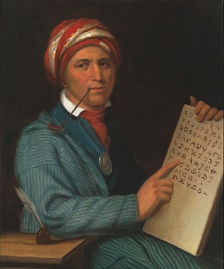
Great Tellico was a Cherokee town at the site of present-day Tellico Plains, Tennessee, where the Tellico River emerges from the Appalachian Mountains. Great Tellico was one of the largest Cherokee towns in the region, and had a sister town nearby named Chatuga. Its name in Cherokee is more properly written Talikwa, but more commonly known as Diligwa. It is sometimes spelled Telliquo, Telliquah or, in Oklahoma, Tahlequah. There were several Cherokee settlements named Tellico, the largest of which is distinguished from the others by calling it "Great". The meaning of the word "Talikwa" is thought to be lost by the Cherokees. However, in an article authored by reporter Tesina Jackson of the Cherokee Phoenix the meaning of the word is stated as "the open place where the grass grows".
Trail of Tears State Park is a public recreation area covering 3,415 acres (1,382 ha) bordering the Mississippi River in Cape Girardeau County, Missouri. The state park stands as a memorial to those Cherokee Native Americans who died on the Cherokee Trail of Tears. The park's interpretive center features exhibits about the Trail of Tears as well as displays and specimens of local wildlife. An archaeological site in the park was added to the National Register of Historic Places in 1970.

Red Clay State Historic Park is a state park located in southern Bradley County, Tennessee, United States. The park preserves the Red Clay Council Grounds, which were the site of the last capital of the Cherokee Nation in the eastern United States from 1832 to 1838 before the enforcement of the Indian Removal Act of 1830. This act resulted in a forced migration of most of the Cherokee people to present-day Oklahoma known as the Cherokee removal. At the council grounds, the Cherokee made multiple unsuccessful pleas to the U.S. government to be allowed to remain in their ancestral homeland. The site is considered sacred to the Cherokees, and includes the Blue Hole Spring, a large hydrological spring. It is also listed as an interpretive center along the Trail of Tears National Historic Trail.
This is a timeline of events in the history of the Cherokee Nation, from its earliest appearance in historical records to modern court cases in the United States. Some basic content about the removal of other southeastern tribes to lands west of the Mississippi River is included. In a series of treaties, these tribes ceded land to the United States.
The Cherokee removal, part of the Indian removal, refers to the removal of an estimated 15,500 Cherokees and 1,500 African-American slaves from the U.S. states of Georgia, North Carolina, Tennessee and Alabama to the West according to the terms of the 1835 Treaty of New Echota. It is estimated that 3,500 Cherokees and African-American slaves died en route.

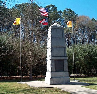
Cherokee Removal Memorial Park is a public park in Meigs County, Tennessee that is dedicated in memory of the Cherokee who were forced to emigrate from their ancestral lands during the Cherokee removal, in an event that came to be known as the Trail of Tears. It was established in 2005, and has since expanded.
The Hiwassee River Heritage Center is a history museum located in Charleston, Tennessee which was established in 2013. The museum chronicles the region's Cherokee and Civil War history. It is a certified interpretive center on the Trail of Tears National Historic Trail.