
Belfast is the capital city and principal port of Northern Ireland, standing on the banks of the River Lagan and connected to the open sea through Belfast Lough and the North Channel. It is the second-largest city on the island of Ireland, with an estimated population of 348,005 in 2022, and a metropolitan area population of 671,559.

Carrickfergus is a large town in County Antrim, Northern Ireland. It sits on the north shore of Belfast Lough, 11 miles (18 km) from Belfast. The town had a population of 28,141 at the 2021 census. It is County Antrim's oldest town and one of the oldest towns in Ireland as a whole. Carrickfergus Castle, built in the late 12th century at the behest of Anglo-Norman knight John de Courcy, was the capital of the Earldom of Ulster. After the earldom's collapse, it remained the only English outpost in Ulster for the next four centuries. Carrickfergus was the administrative centre for Carrickfergus Borough Council, before this was amalgamated into the Mid and East Antrim District Council in 2015, and forms part of the Belfast Metropolitan Area. It is also a townland of 65 acres, a civil parish and a barony.

Glengormley is a townland and electoral ward in County Antrim, Northern Ireland. Glengormley is within the urban area of Newtownabbey bordering Belfast, and is located in the Antrim and Newtownabbey Borough Council area. It is also situated in the civil parish of Carnmoney and the historic barony of Belfast Lower.

Castlederg is a town in County Tyrone, Northern Ireland. It lies on the River Derg and is near the border with County Donegal, Ireland. It stands in the townlands of Castlesessagh and Churchtown, in the historic barony of Omagh West and the civil parish of Urney. The village has a ruined castle and two ancient tombs known as the Druid's Altar and Todd's Den. It had a population of 2,980 people at the 2021 census.
Carnmoney is the name of a townland, electoral ward and a civil parish in County Antrim, Northern Ireland. Carnmoney is within the urban area of Newtownabbey, in the Antrim and Newtownabbey Borough Council area. It lies 7 miles (11 km) from Belfast city centre in the historic barony of Belfast Lower.
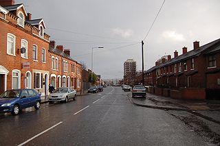
The New Lodge is an urban, working class Catholic community in Belfast, Northern Ireland, immediately to the north of the city centre. The landscape is dominated by several large tower blocks. The area has a number of murals, mostly sited along the New Lodge Road. The locality is demarcated by Duncairn Gardens, Antrim Road, Clifton Street, and dependent on opinion, York Street or North Queen Street. North Queen Street and Duncairn Gardens have often seen rioting between republicans and loyalists. The New Lodge is also an electoral ward of Belfast City Council.

Belfast North is a parliamentary constituency in the United Kingdom House of Commons. The current MP is John Finucane.

Crumlin is a village in County Antrim, Northern Ireland.

Belfast City Council is the local authority with responsibility for part of Belfast, the largest city of Northern Ireland. The council serves an estimated population of 348,005 (2022), the largest of any district council in Northern Ireland, while being the smallest by area. Belfast City Council is the primary council of the Belfast Metropolitan Area, a grouping of six former district councils with commuter towns and overspill from Belfast, containing a total population of 579,276.

Greenisland is a town in County Antrim, Northern Ireland. It lies 7 miles north-east of Belfast and 3 miles south-west of Carrickfergus. The town is on the coast of Belfast Lough and is named after a tiny islet to the west, the Green Island.

Dundonald is a large settlement and civil parish in County Down, Northern Ireland, United Kingdom. It lies east of Belfast and is often considered a suburb of the city. It is home to the Ulster Hospital, Dundonald International Ice Bowl, Dundonald Omnipark, has a Park and Ride facility for the Glider, access to the Comber Greenway and several housing developments. John de Courcey established a keep including a motte-and-bailey in the 12th century. This is known as Moat Park and can be accessed from Church Green, Comber Road and the Upper Newtownards Road.
Poleglass is an area of west Belfast in Northern Ireland. It is the name of a townland, a modern electoral ward, and a working class suburb. The townland is situated in the civil parish of Derriaghy and the historic Barony of Belfast Upper. It is mainly an Irish nationalist area.

Andersonstown, known colloquially as Andytown, is a suburb of west Belfast, Northern Ireland, at the foot of the Black Mountain and Divis Mountain. It contains a mixture of public and private housing and is largely a working-class area with a strong Irish nationalist and Irish Catholic tradition. The district is sometimes colloquially referred to as "Andytown". This area stretches between the Shaws Road, the Glen Road and the Andersonstown Road.

Belleeks is a small village and townland in south County Armagh, Northern Ireland. In the 2011 Census it had a reported population of 375. It lies within the Newry, Mourne and Down District Council area and the historic barony of Upper Fews.

Cregagh is an area in the southeast of Belfast, Northern Ireland. It is the name of a townland and has been adopted as the name of an electoral ward of Belfast City council. The townland dates back to medieval times, when it was part of the territory held by the O'Neills of Clannaboy. The area is centred on the Cregagh Road. The Woodstock/Cregagh Road is a continuous arterial route in the city, with the Woodstock making up the lower half of the route and the Cregagh the upper half. It runs from the Albertbridge Road, close to the Short Strand, to the A55 Outer Ring road.
Jordanstown is a townland and electoral ward in County Antrim, Northern Ireland. It is within the urban area of Newtownabbey and the Antrim and Newtownabbey Borough Council area. It is also situated in the civil parish of Carnmoney and the historic barony of Belfast Lower. It had a population of 6,225 in the 2011 census, with an average age of 40.
The electoral wards of Belfast are subdivisions of the city, used primarily for statistics and elections. Belfast had 51 wards from May 1973, which were revised in May 1985 and again in May 1993. The number of wards was increased to 60 with the 2014 changes in local government. Wards are the smallest administrative unit in Northern Ireland and are set by the Local Government Boundaries Commissioner and reviewed every 8–12 years.

Victoria was one of the nine district electoral areas (DEA) in Belfast, Northern Ireland, from 1985 to 2014, when it was mostly replaced by the Ormiston district.
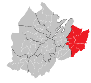
Ormiston has been one of the ten district electoral areas (DEA) in Belfast, Northern Ireland since 2014. Located in the east of the city, the district elects seven members to Belfast City Council and contains the wards of Belmont, Garnerville, Gilnahirk, Sandown, Shandon, Knock and Stormont. Ormiston, along with wards from the neighbouring Titanic and Lisnasharragh DEAs, together with parts of Lisburn and Castlereagh District Council, form the Belfast East constituency for the Northern Ireland Assembly and UK Parliament.
Area B was one of the eight district electoral areas (DEA) which existed in Belfast, Northern Ireland from 1973 to 1985. Located in the east of the city, the district elected seven members to Belfast City Council and contained the wards of Ballyhackamore; Belmont; Bloomfield; Island; Knock; Shandon; and Stormont. The DEA formed part of the Belfast East constituency.
