In ecology, a marsh is a wetland that is dominated by herbaceous plants rather than by woody plants. More in general, the word can be used for any low-lying and seasonally waterlogged terrain. In Europe and in agricultural literature low-lying meadows that require draining and embanked polderlands are also referred to as marshes or marshland.

The Tippecanoe River is a gentle, 182-mile-long (293 km) river in the Central Corn Belt Plains ecoregion in northern Indiana. It flows from Crooked Lake in Noble County to the Wabash River near what is now Battle Ground, about 12 miles (19 km) northeast of Lafayette. The name "Tippecanoe" was derived from a Miami-Illinois word for buffalo fish, reconstructed as */kiteepihkwana/ or as kiteepihkwana siipiiwi.

The Cedar River is a river in the U.S. state of Washington. About 45 miles (72 km) long, it originates in the Cascade Range and flows generally west and northwest, emptying into the southern end of Lake Washington. Its upper watershed is a protected area called the Cedar River Watershed, which provides drinking water for the greater Seattle area.

The Sacramento perch is from the family Centrarchidae, characterized by dorsal fins with spiny elements and known for its nesting behavior. There are about 31 species in this family, which include sunfishes, crappies, and basses. The Sacramento perch is considered in the sunfish group. It is the only species of Centrarchidae whose native habitat resides west of the Rocky Mountains, while all the other species are native to the east.

Vernal pools, also called vernal ponds or ephemeral pools, are seasonal pools of water that provide habitat for distinctive plants and animals. They are considered to be a distinctive type of wetland usually devoid of fish, and thus allow the safe development of natal amphibian and insect species unable to withstand competition or predation by fish. Certain tropical fish lineages have however adapted to this habitat specifically.

The Coquitlam River is a tributary of the Fraser River in the Canadian province of British Columbia. The river's name comes from the word Kʷikʷəƛ̓əm which translates to "Red fish up the river". The name is a reference to a sockeye salmon species that once occupied the river's waters.
Cootes Paradise is a property with many boundaries, but it is primarily a property of the Royal Botanical Gardens at the western end of Lake Ontario, but is also remnant of the larger 3700 acre Dundas Marsh Crown Game Preserve established by the province of Ontario in 1927., dominated by a 4.5 km long rivermouth wetland, representing the lake's western terminus. It is found on the west side of Hamilton Harbour and is located in the municipality of Hamilton, Ontario, Canada. Cootes Paradise Environmentally Sensitive Area is larger "core area" within the City of Hamilton's Natural Heritage System and has a very similar boundary to the original Dundas Crown Game Preserve.

Lake Jackson is a shallow, prairie lake on the north side of Leon County, Florida, United States, near Tallahassee, with two major depressions or sinkholes known as Porter Sink and Lime Sink.

A garden pond is a water feature constructed in a water garden or designed landscape, normally for aesthetic purposes, to provide wildlife habitat, or for swimming.

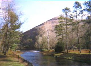
Kettle Creek is a tributary of the West Branch Susquehanna River running through Tioga, Potter, and Clinton counties, in Pennsylvania. It is slightly less than 43 miles (69 km) long. Although many streams in the Kettle Creek watershed are considered "Class A Wild Trout streams" by the Pennsylvania Fish and Boat Commission, the lower reaches of the stream experience acid mine drainage. The upper reaches of the creek are considered to be very high-quality.

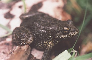
The northern red-legged frog is a species of amphibian whose range is the coastal region stretching from southwest British Columbia to southern Mendocino County in Northern California, and is protected in Oregon and California. As a member of the genus Rana, this species is considered a true frog, with characteristic smooth skin and a narrow waist. This frog requires still waters for breeding, and is rarely found at any great distance from its breeding ponds or marshes.

A pond is a small, still, land-based body of water formed by pooling inside a depression, either naturally or artificially. A pond is smaller than a lake and there are no official criteria distinguishing the two, although defining a pond to be less than 5 hectares in area, less than 5 metres (16 ft) in depth and with less than 30% of its area covered by emergent vegetation helps in distinguishing the ecology of ponds from those of lakes and wetlands. Ponds can be created by a wide variety of natural processes, or they can simply be isolated depressions filled by runoff, groundwater, or precipitation, or all three of these. They can be further divided into four zones: vegetation zone, open water, bottom mud and surface film. The size and depth of ponds often varies greatly with the time of year; many ponds are produced by spring flooding from rivers. Ponds are usually freshwater but may be brackish in nature. Saltwater pools, with a direct connection to the sea to maintain full salinity, may sometimes be called 'ponds' but these are normally regarded as part of the marine environment. They do not support fresh or brackish water-based organisms, and are rather tidal pools or lagoons.

Glenmere Lake is a colonial mill pond or reservoir located in Orange County, New York, United States. It is New York State's largest habitat of the Northern cricket frog, listed as endangered by in New York State Department of Environmental Conservation records

Smith and Bybee Wetlands Natural Area is a public park and nature reserve between the Columbia Slough and the Columbia River in Portland, Oregon. At about 2,000 acres (810 ha), it is one of the largest urban freshwater wetlands in the United States. Metro, the regional government for the Oregon part of the Portland metropolitan area, manages the park. A covered shelter, restrooms, a paved walkway, and a canoe launch lie on the north side of the natural area.

The Rock House Reservation is a 196-acre (79 ha) open space preserve located in West Brookfield, Massachusetts. The property, acquired in 1993 by the land conservation non-profit organization The Trustees of Reservations, is named for a natural rock shelter once used as a winter camp by Native Americans. Its location near two, long Native American footpaths suggests that it may also have been a trail camp and meeting place.

The Sierra Nevada yellow-legged frog or Sierra Nevada Mountain yellow-legged frog is a true frog endemic to the Sierra Nevada of California and Nevada in the United States. It was formerly considered Rana muscosa until a 2007 study elevated the more central and northern populations to full species status, restricting R. muscosa to the southern Sierra Nevada and southern California.

The Sonny Bono Salton Sea National Wildlife Refuge is located in the Imperial Valley of California, 40 miles (64 km) north of the Mexican border. Situated at the southern end of the Salton Sea, the refuge protects one of the most important nesting sites and stopovers along the Pacific Flyway. Despite its location in the Colorado Desert, a subdivision of the larger Sonoran Desert, the refuge contains marine, freshwater, wetland, and agricultural habitats which provide sanctuary for hundreds of birds and wetland species, including several that have been listed as endangered or sensitive by the U.S. Fish and Wildlife Service.

There are 14 species of amphibians and 5 species of reptiles known to occur in Mount Rainier National Park.

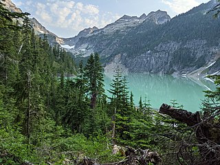
An alpine lake is a high-altitude lake in a mountainous area, usually near or above the tree line, with extended periods of ice cover. These lakes are commonly glacial lakes formed from glacial activity but can also be formed from geological processes such as volcanic activity or landslides. Many alpine lakes that are fed from glacial meltwater have the characteristic bright turquoise green color as a result of glacial flour, suspended minerals derived from a glacier scouring the bedrock. When active glaciers are not supplying water to the lake, such as a majority of Rocky Mountains alpine lakes in the United States, the lakes may still be bright blue due to the lack of algal growth resulting from cold temperatures, lack of nutrient run-off from surrounding land, and lack of sediment input. The coloration and mountain locations of alpine lakes attract lots of recreational activity.


