
The Illinois and Michigan Canal connected the Great Lakes to the Mississippi River and the Gulf of Mexico. In Illinois, it ran 96 miles (154 km) from the Chicago River in Bridgeport, Chicago to the Illinois River at LaSalle-Peru. The canal crossed the Chicago Portage, and helped establish Chicago as the transportation hub of the United States, before the railroad era. It was opened in 1848. Its function was partially replaced by the wider and deeper Chicago Sanitary and Ship Canal in 1900, and it ceased transportation operations with the completion of the Illinois Waterway in 1933.

Michigan Avenue is a north-south street in Chicago that runs at 100 east on the Chicago grid. The northern end of the street is at Lake Shore Drive on the shore of Lake Michigan in the Gold Coast Historic District. The street's southern terminus is at Sibley Boulevard in the southern suburb of Dolton, but like many other Chicago streets, it exists in several disjointed segments.

The Chicago Tunnel Company was the builder and operator of a 2 ft narrow-gauge railway freight tunnel network under downtown Chicago, Illinois. This was regulated by the Interstate Commerce Commission as an interurban even though it operated entirely under central Chicago, did not carry passengers, and was entirely underground. It inspired the construction of the London Post Office Railway.
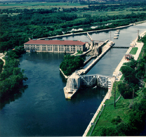
The Chicago Sanitary and Ship Canal, historically known as the Chicago Drainage Canal, is a 28-mile-long (45 km) canal system that connects the Chicago River to the Des Plaines River. It reverses the direction of the Main Stem and the South Branch of the Chicago River, which now flows out of Lake Michigan rather than into it. The related Calumet-Saganashkee Channel does the same for the Calumet River a short distance to the south, joining the Chicago canal about halfway along its route to the Des Plaines. The two provide the only navigation for ships between the Great Lakes Waterway and the Mississippi River system.

The Milwaukee Metropolitan Sewerage District (MMSD) is a regional government agency that provides water reclamation and flood management services for about 1.1 million people in 28 communities in the Greater Milwaukee Area. A recipient of the U.S. Water Prize and many other awards, the District has a record of 98.4 percent, since 1994, for capturing and cleaning wastewater from 28 communities in a 411-square-mile (1,060 km2) area. The national goal is 85 percent of all the rain and wastewater that enters their sewer systems.
The Tunnel and Reservoir Plan is a large civil engineering project that aims to reduce flooding in the metropolitan Chicago area, and to reduce the harmful effects of flushing raw sewage into Lake Michigan by diverting storm water and sewage into temporary holding reservoirs. The megaproject is one of the largest civil engineering projects ever undertaken in terms of scope, cost and timeframe. Commissioned in the mid-1970s, the project is managed by the Metropolitan Water Reclamation District of Greater Chicago. Completion of the system is not anticipated until 2029, but substantial portions of the system have already opened and are currently operational. Across 30 years of construction, over $3 billion has been spent on the project.
Northwest Indiana, nicknamed The Region after the Calumet Region, comprises Lake, Porter, LaPorte, and Newton counties in Indiana. This region neighbors Lake Michigan and is part of the Chicago metropolitan area. According to the 2020 Census, Northwest Indiana has a population of 831,080 and is the state's second largest urban area after the Indianapolis Metropolitan Area. It is also the home of the Indiana Dunes, parts of which have been preserved through conservation efforts. The town of Ogden Dunes houses the Hour Glass, a museum showcasing the ecological and conservation efforts of O. D. Frank.

The water cribs in Chicago are structures built to house and protect offshore water intakes used to supply the City of Chicago with drinking water from Lake Michigan. Water is collected and transported through tunnels located close to 200 feet (61 m) beneath the lake, varying in shape from circular to oval, and ranging in diameter from 10 to 20 feet. The tunnels lead from the water cribs to Pumping Stations located onshore, then to water purification plants Jardine Water Purification Plant and the Sawyer Water Purification Plant, where the water is then treated before being pumped to all parts of the city as well as 118 suburbs.

Lake Chicago was a prehistoric proglacial lake that is the ancestor of what is now known as Lake Michigan, one of North America's five Great Lakes. Formed about 13,000 years ago and fed by retreating glaciers, it drained south through the Chicago Outlet River.
The Chicago 1885 cholera epidemic myth is a persistent urban legend, stating that 90,000 people in Chicago died of typhoid fever and cholera in 1885. Although the story is widely reported, these deaths did not occur.

The Cheboygan Crib Light is a light that marks the west pier head of the mouth of the Cheboygan River into Lake Huron. The pier head, in the center of the municipality of Cheboygan, is located at the north or lake end of Huron Street, and is one of the centerpieces of Cheboygan's Gordon Turner Park.
During the 1850s and 1860s, engineers carried out a piecemeal raising of the level of central Chicago to lift it out of low-lying swampy ground. Streets, sidewalks, and buildings were physically raised on jackscrews. The work was funded by private property owners and public funds.

Spectacle Reef Light is a lighthouse 11 miles (18 km) east of the Straits of Mackinac and is located at the northern end of Lake Huron, Michigan. It was designed and built by Colonel Orlando Metcalfe Poe and Major Godfrey Weitzel, and was the most expensive lighthouse ever built on the Great Lakes.
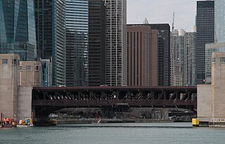
The Outer Drive Bridge, also known as the Link Bridge, is a double-deck bascule bridge carrying Lake Shore Drive across the Chicago River in Chicago, Illinois, United States. Construction was started in 1929 and was completed in 1937 as one of the Public Works Administration's infrastructure projects in Chicago. The bridge is officially named the Franklin Delano Roosevelt Memorial Bridge to honor the centennial anniversary of the birth of Franklin Delano Roosevelt. It was planned by the Chicago Plan Commission, using Hugh E. Young as the consulting engineer, was designed by the Strauss Engineering Company, built by the American Bridge Company, and erected by Ketler and Elliot Company. It crosses near the mouth of the Chicago River.

Ellis Sylvester Chesbrough (1813–1886) was an engineer credited with the design of the Chicago sewer system, which are sometimes known as the 'Chesbrough sewers'. This was the first comprehensive sewer system in the United States. He is responsible for the plan to raise Chicago, construction of the first water crib in Chicago, and designing the Boston water distribution system. The water system he designed for Chicago is on the National Register of Historic Places and has been designated a Historical Civil Engineering Landmark by the American Society of Civil Engineers.

The Keweenaw Waterway Lower Entrance Light, also known as the Portage Entry Light, is a lighthouse located at the south end of breakwater at mouth of the Portage River in Torch Lake Township. It was listed on the National Register of Historic Places in 2014.
The Sawyer Water Purification Plant, formerly the South Water Purification Plant, is the first water filtration plant built in the City of Chicago. When completed in 1947, it was the largest such plant in the world.

Seattle Municipal Light and Power Plant, also known as Cedar Falls Historic District, is a public hydroelectric plant near North Bend, Washington operated by Seattle City Light. The plant was the first publicly-owned electrical generating plant for Seattle and one of the earliest in the country for a municipality of its size. It was listed on the National Register of Historic Places in 1997.


